Not for the block bounded by Sheppard, Richmond, Bay and Adelaide.

AoD

Oh ok, I haven't been following the development proposals that closely. I just knew that there were a few in that area. In any event, those new projects will likely fill in some of the gaps between the King & Bay area and the Queen & Bay area. I don't think we'll have to worry about a big public sector PATH expansion, since I think most of it will be taken care of via the private sector developments that are/will be happening.
 
Oh ok, I haven't been following the development proposals that closely. I just knew that there were a few in that area. In any event, those new projects will likely fill in some of the gaps between the King & Bay area and the Queen & Bay area. I don't think we'll have to worry about a big public sector PATH expansion, since I think most of it will be taken care of via the private sector developments that are/will be happening.

It will be interesting to see - that block might be tough given the concentration of heritage structures (not that it has ever prevented ever more ambitious facadism). Hence I suggested a Bay PATH extension entirely in the public ROW.

AoD
 
It will be interesting to see - that block might be tough given the concentration of heritage structures (not that it has ever prevented ever more ambitious facadism). Hence I suggested a Bay PATH extension entirely in the public ROW.

AoD

If office demand continues the way it is, I think facadism will win out over genuine heritage preservation. In any case, the PATH extension doesn't need to open on Day 1 with the station, there just has to be provisions in place to accommodate it. The only public sector PATH improvements that really should be happening in conjunction with the DRL station are in NPS itself, specifically in relation to the parking lot.
 
This particular argument and its narrow focus on the downtown core ignores all the explosive growth that is happening all along King street beyond the small handful of city blocks in the financial district. King & Bay may be 9-5, but what about the dozen other subway stations that could have been in the heart of the Entertainment District, Liberty Village, St Lawrence, or Distillery District for example? Moss Park is definitely not 24/7.

According to this evaluation criteria, the King alignments received the same overall score as the preferred option. But King scored a lot better at one very important criteria that should have been given more weight: "supports city growth". If being less affordable than Queen is the biggest disadvantage, that is a rather sad excuse to not select that alignment. If King is better for the city (assuming that is the case), then it should have been pursued. The DRL is the last transit project that anyone should be cheapening out on. The investment we make here will live on for the rest of our lives and have a profound impact on the city's future.

View attachment 67159

View attachment 67157.

It's called the Toronto Cheapening like they did for the Scarborough subway but I suppose what's good for the goose is good for the gander.

Your picture shows how unprofessional the reports churned out by the planning department are when childish criteria (if you can even call it that) are given the same weight as grown up things.

Re: the City's current Phase I plan, and what the future will hold for its northerly extensions or whether it will be built as envisioned, I think the jury is most definitely still out on that (pending the release of the Prov's YRNS study and what it highlights). Even for the shortlist we're being shown now it seems too early to put our eggs in one basket and say Pape-Queen-City Hall is definitive. It's quite probable that in a year or two once YRNS is complete, we could join forces with the Prov and move toward some kind of hybrid between the City/TTC plan and Metrolinx's plans. Example, the City's A and C could morph into YRNS Surface Subway at Chester Hill; or A, B, C, D could do the same at Millwood/Overlea. Also, in YRNS' last doc it's acknowledged that a combination of plans is a possibility in the future.

6.21
While this study did not include an option that combines the long subway/surface subway and the U Subway options, such a project may be considered for a timeframe outside of the scope of this study in future option analysis and development.

When reading over the City's latest numbers, it looks like without SmartTrack and without any gerrymandering to Unilever (i.e the recent "B2" and "D2" ideas), Broadview-King provides the highest ridership (26,800 peak hour, 54,800 peak period, 165k daily boardings); and highest Yonge diversion (4,200 peak hour, or 35% reduction from 2031 Base). So I wouldn't doubt that Metrolinx will use this data to further refine their ideas, or change plans even further (e.g proposing a Relief Line Medium only as far north as Eglinton, perhaps using Broadview). This could definitely change the dynamics of Yonge relief, but further delay the City's attempts at proper bottom-up city-building planning.

Current routes (excluding recent B2 and D2 to Unilever):

View attachment 67208
I was wonderin how long it'd take you. The reason for what you're seeing isn't because 44 North's pet project is better than Keesemat's pet project. It's because the chief planner is too narrow minded. It only looks better on paper because she refuses to consider a subway to poor areas like East York and Thorncliffe Park so all of the poor are forced to take buses to Broadview. I guess social justice is a concern only for the nouveau poor in Regent Park.
 
I was wonderin how long it'd take you. The reason for what you're seeing isn't because 44 North's pet project is better than Keesemat's pet project. It's because the chief planner is too narrow minded. It only looks better on paper because she refuses to consider a subway to poor areas like East York and Thorncliffe Park so all of the poor are forced to take buses to Broadview. I guess social justice is a concern only for the nouveau poor in Regent Park.

haha, it took longer than it could've...had to hold back a bit. But honestly, IMO Keesmaat is doing much less cheapening than Metrolinx. And I put my trust in the City for doing bottom-up city-building planning, even if they do try to cut costs. If you want to blast a person/organization for cheapening, blast the Prov/Metrolinx for still not acknowledging a RL needs to be subway. Their nonsense xKingx *FRONT STEET* LRT relief tram idea made it to the shortlist phase, and could very well end up being their shortlisted RL... that's cheapening. At least Keesmaat is adamant this can only be a subway and must be a priority.

But I guess the takeaway from my point is that you still could get a subway along King with proper connections to YUS, considering that the plans are still preliminary and we've yet to see the Prov's YRNS final docs.
 
Last edited:
Their nonsense King LRT relief tram idea made it to the shortlist phase, and could very well end up being their shortlisted RL... that's cheapening. At least Keesmaat is adamant this can only be a subway and must be a priority.

I don't think anyone is seriously suggesting that the King LRT/Transit Mall is a substitute for the DRL. It's a band-aid solution that can be implemented pretty much immediately, and can boost capacity and efficiency until the DRL is actually operational.
 
I don't think anyone is seriously suggesting that the King LRT/Transit Mall is a substitute for the DRL. It's a band-aid solution that can be implemented pretty much immediately, and can boost capacity and efficiency until the DRL is actually operational.

Whoops, meant YRNS Front Street LRT relief line the Prov shortlisted.
 
Whoops, meant YRNS Front Street LRT relief line the Prov shortlisted.

The Waterfront LRT you mean? I don't think that will serve as much of a relief line, since it doesn't connect to Bloor-Danforth at either end. It may help relieve the west end and the Humber Bay area though, but that part of the Relief Line was always a Phase II project. The east end it doesn't serve anything north of Queen, really.

In short, I don't see the two as really cannabalizing each other's ridership, since they're serving different trip patterns.

No, no. I'm talking about one of the Prov's shortlisted Relief Line routes from their YRNS document this summer. Basically there were three shortlisted options: 1. Long/Short/U Subway, 2. Surface Subway, and 3. Surface LRT (<- leads to p. 29 of YRNS Technical document).

This LRT line was to be fully grade-separated from Sheppard to downtown except along Front Street where it would terminate at Union. It's ass backwards to run a relief line on the surface through traffic in the densest area of the country, and clearly shows the Prov isn't willing to accept TO's relief line criteria. But the Prov (alongside York Region) could very well choose this as their #1 option when they finalize their YRNS study. It's quick and dirty and cheap, and if in place along with ST/Stouffville RER could give enough relief to greenlight Yonge North.

Oh gotcha. Yeah, I don't really see that option moving forward very far.
 
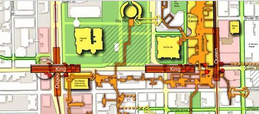
Looking at the path map - despite what would be the closest two stations together on the TTC (this about 260m apart, I just wonder why they are not building a station at Osgoode and City hall. It would allow a direct platform to platform connection in the middle of the two stations (quickly done in paint...):

ttcrl.png


And would allow a direct connection on a portion of the subway that can currently, and likely far into the future accept the volume, and if somebody wants to go to union they now have a direction connection.

Well, two interchange stations doesn't constitute as the psychological centre of the city so -50 points for that option. :cool:

In all seriousness though, ideal station placement would have City Hall station as close to Queen station as possible while still straddling Bay Street and an interchange with the University Line would be immediately west of Osgoode from Simcoe to Duncan. Cost must be the sole reason why this type of arrangement isn't being considered.

Then again, perhaps a direct University Line connection would be considered along with the westward extension, wherever that ends up going.
 
the City Hall station ends up more around Bay Street, I could totally see a new station being built around Simcoe to connect to Osgoode as part of the western DRL extension.
 
Considering the intent is to get people walking north from King and Bay, there ought to be entrances very close to York and to Bay. Entrances and platform need not exactly align, people lose their orientation when they go downstairs.. I wonder about having the Yonge station so far west. If you place the platform to the east side of Yonge, you make it more attractive to people walking north-south a block or two east of yonge. Ryerson in particular would benefit from this.

I can't help wondering why it doesn't go one stop further. I'm thinking of those huge crowds flooding out of Blue Jay games. Many walk all the way to Queen now....finding a subway station up there around John or Peter that goes east just seems marketable.

- Paul
 
University to Spadina is a big distance and there are many destinations in between. I agree that a station platform just immediately to the west of Osgoode Station providing an interchange as well as station entrances at Duncan or John Streets is highly favourable.
 

Back
Top