While I'd love for a Spadina stop, to me it seems like John is simply too close to University/Osgoode for a station (5 min walk).
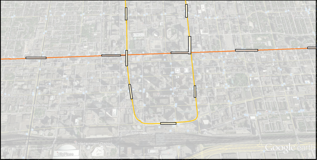
 
^ It's actually meant to be a transfer station:


I envision the station taking up the block between McCaul and Simcoe Streets with pedestrian walkways extending west to John and east to the Osgoode Subway Stn. I see the Toronto City Centre Stn more as taking up the block in-between Bay and Yonge, although a continuous fare-paid zone could exist from Yonge to University via TCC Stn.
 
I feel like this thread has been derailed quite a bit, so to get things back on topic:


Simple DRL Phase 1 in tune with the recent developments in the news. I extend it one kilometre over to Spadina to intercept the busy 510 Spadina streetcar. I also added back in a Parliament Stn by shifting the stop intended for Sherbourne west to Jarvis St (a walk-in transfer to the 75 bus via Moss Park); and placed a station at Queen and Carlaw to lessen the commute from Leslieville and the Beaches to the nearest subway.

This is exactly the Phase 1 plan I've had in my head. Extending it to Spadina is actually quite critical, there is a lot of employment and destinations there, enough to convince substantial amount of people to transfer at Pape rather than continue on Line 1.

Jarvis and Parliament feel more suitable for stations, they have greater redevelopment potential, and are not duplicates of Line 2 (which annoys me greatly, even if it is a silly concern). Sherbourne is in walking distance of both.

While I'd love for a Spadina stop, to me it seems like John is simply too close to University/Osgoode for a station (5 min walk).

I don't think it is too bad for the densest part of our city. Plus it can provide a transfer with Osgoode station.
 
There's an unexplained phenomena where governments suddenly find money nobody thought we had at election time.

But seriously, nobody here can say since we don't have access to the provincial books. But if the Liberals want it done, they'll get it done.

Politicians have never needed the downtown vote to win an election, and I don't see why it will be any different next time around. The Liberals are about halfway into their majority mandate, how many Toronto transit projects did they fund since the last election? Where is the funding that was promised for the East Bayfront LRT? Whatever new money they found so far is going almost entirely toward GO transit improvements and suburban LRT/BRT projects in the 905.
 
Does this make Gerrard a transfer stop for whatever heavy rail (RER, ST or whatever) comes down the LSE? That gets some GO users away from Union altogether. Many would not want the transfer, but for some it might appeal.

- Paul
 
Does this make Gerrard a transfer stop for whatever heavy rail (RER, ST or whatever) comes down the LSE? That gets some GO users away from Union altogether. Many would not want the transfer, but for some it might appeal.

It may well draw some away from Union. It can also provide some redundancy to the system as another way into/out of downtown.

AoD
 
Politicians have never needed the downtown vote to win an election, and I don't see why it will be any different next time around. The Liberals are about halfway into their majority mandate, how many Toronto transit projects did they fund since the last election? Where is the funding that was promised for the East Bayfront LRT? Whatever new money they found so far is going almost entirely toward GO transit improvements and suburban LRT/BRT projects in the 905.

We are walking a huge tightrope on funding infrastructure generally. It could end at any time. Having said that, the first rule of working at heights is 'don't look down'. The only way DRL will happen is to just keep pushing regardless.

This project touches not only the downtown voters, but also all the east/north subway riders, so it will attract votes right up into Thornhill. I wonder if the ends of Phase 1 ought to stretch just a little further north into East York and west from Spadina. That's another $1B+, but it's more voters per km.

- Paul
 
With what $?

Did the provincial government just come into billions of dollars and nobody told us?

The province's resources are stretched even to make committed-to projects, let alone another huge one which the RL represents.

Well there's $8 billion that's been promised for SmartTrack, which is going to need nowhere near that amount now that Eglinton West has been chopped off. Even if you still use half of that for SmartTrack (which is still an overestimation IMO, since it's really just RER with additional stops), that still leaves you a pretty decent amount for the DRL...

...Or you just divert SmartTrack into the DRL tunnel and package it as a cross-Toronto 'subway' instead of just a downtown subway.
 
I see the Toronto City Centre Stn more as taking up the block in-between Bay and Yonge, although a continuous fare-paid zone could exist from Yonge to University via TCC Stn.
Assuming that NPS will be the terminal station on Relief Line Phase 1, and given the incremental cost of mining under two subway lines rather than one I do, then the positioning of the station box will be interesting.

The easiest place to put it is west of Bay, within the Nathan Phillips car park / under Nathan Phillips Square. The construction will be non trivially difficult given the need to partly deconstruct a multilevel car park but the City owns the land and there isn't massive construction above grade, though the walkway may be impacted. The lawn south of Osgoode Hall could also be used in some manner (though I imagine not without significant whining).

The thing is, I suspect that there will be no tail tracks in this configuration because if there are AND construction stops short of University Avenue to contain phase 1 cost then it is unlikely the station box can be kept west of Bay, which I think would be preferred as opposed to having to close Bay and constructing even part of the box between the Eaton Centre and Old City Hall on one side, and the Bay on the other, as pictured above. Deleting the tail tracks then impacts the minimum headway between trains, even assuming automatic operation.

A 175 metre platform/box could fit in the footprint from Osgoode Lane to Bay Street (with the construction zone probably extending to York St). Think it's safe to say City Hall Car Park south entrance is gone along with a chunk of the car park so the SB Bay-WB Queen slip road can go and a no-right ban imposed, giving another 10 metres or so to the east for construction buffering. This makes the Yonge-NPS transfer distance about 250 metres, about 175 metres to Osgoode from the west end of the platform. That's a non-trivial difference but could be managed with travelators.

If a second, downtown station was required east of Yonge then I'd be looking hard at Victoria-Church (hello Metropolitan United, nice front lawn you have there). This is also not a hop and skip to Yonge, but one thing we should also be ensuring in this process is (1) Relief Line, like Crosstown, is self-contained for traction power including failover and (2) security or other issues at Yonge or Osgoode should not necessarily shut down Relief Line. A little distance is not necessarily a bad thing.
 
The business district, and in some ways the city as a whole, is shifting south, probably south-east. We can develop over the train tracks. Lakeshore Blvd. unencumbered by the Gardiner is somewhat of a blank slate. We can have the bike lanes and grand tree-lined median and boulevards, and we can build a human scale streetscape with 4-6 storey podiums, art, parkettes, whatever the city plans. Developers will contribute to the boulevard improvements. It could really have that monumental beaux-arts promenade feel and become a centre of gravity for the city. We never achieved that on University Ave.
Having spent the first 7 years of my career designing tunnel boring machines, including those for TYSSE and Crosstown, as much as I love tunnels, the challenges just wouldn't make it a viable business case, even as a tolled asset where a developer could reap the tolls. The scale of tunnel you're contemplating is on the order of this, or 14m to 17m tunnel OD, which means a bore up to 18m. You're dealing with about 17m of right of way for Richmond, so you're within feet of foundation piles, which is unacceptable.

And lastly, the ramps need to bored as well, but must also follow minimum grading....that means they'll take up a LOT of horizontal space along their length as they go up through the utility-heavy zone below the streets. The scale of utility locates would be enormous.

My pipe dream for awhile was a bored gardiner near its current alignment, but even that was a extravagantly costed fantasy. Now that I work in management consulting related to capital projects, I can see that the investment will never make it feasible, especially with so many other priorities to fund.
 
So where do you think they would send Relief Line trains for maintenance (in other words, where will there be connecting tracks)? Greenwood or Downsview?
 
Might want to scroll a few pages back to the Chief Planner's tweet saying planning for the DRL is moving full steam ahead...

You'll also need to send her an email telling her she should fire all the staff currently assigned to the DRL, since there is nothing going on according to your observations.

So the chief planner has made some plans.

So what?

If you peruse this thread you'll see decades of such plans and clearly we have no RL.
 
So the chief planner has made some plans.

So what?

If you peruse this thread you'll see decades of such plans and clearly we have no RL.

Show me these plans... maps with lines arbitrarily drawn don't count. Show me the public consultation that went on. Show me the rationale behind station location, or route selection, or the cost estimates. No plans currently exist because it has never moved beyond just an idea until recently. It's never had staff dedicated to it until now.
 
Last edited:

Back
Top