The prospect of walking a few blocks to access the subway, or make a connection between subway lines, is a big change for this city but taken for granted elsewhere. Having only one station serving the University and Yonge sides creates risks. If the Line 1 station is closer, will they walk the additional distance?

I don't know how much risk it'd create necessarily given the rider will do their mental calculation and minimize travel time, transfers and increase comfort for the overall trip - and the Queen/City Hall station is close enough to the core in general. The little J is important (getting the toughest part of the network built), but I'd argue RL really need to be extended north to Eglinton for it to be a draw.

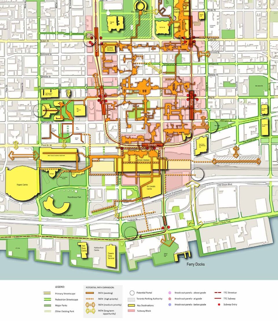
Bringing it back to PATH - from the PATH Master Plan Report:

urbantoronto-10193-36429.jpeg


Any Queen/City Hall station should be plugged into the system quite well. The only issue is the lack of a connection along Bay - but that can be rectified by something akin to the NW PATH extension presumably.

AoD
 
Last edited:
Any Queen/City Hall station should be plugged into the system quite well. The only issue is the lack of a connection along Bay - but that can be rectified by something akin to the NW PATH extension presumably.

I haven't read the PATH report - does it contain the same sort of analysis in terms of % full and people/hour flows that we have for transit?

I agree that PATH will be well positioned to tie into a Queen-Bay Relief Line station. My question is - how many people can the current PATH absorb? Is it filling up just like the Yonge Subway?

My other comment would be - PATH is great in the Union to Queen stretch but not so great in terms of connections to the Hospitals on University or U of T. Or in the shoulder areas - which may be where the next spurt of development (the one that may be assumed in the ridership forecasts) takes place. If you look at it with Queen as the center, it's unbalanced and doesn't reach as far into the surrounding area.

I'm not critical of PATH - quite the opposite, I'm wondering if it will need to be greatly expanded as part of the overall upsizing of transportation in the core. I'm also wondering about more draconian things like reducing Bay or York to two lanes, with wider pedestrian sidewalks.

Lastly, if we had two stations, one on the west side of at Osgoode, and the second with the west end at Yonge and the east end towards Jarvis, we'd have entrances to the DRL that reach much farther east and west, and that has to make the walkability factor that much greater. Nathan Phillips square is cool, but there's no room to grow, and the Sheraton Center puts a damper on how lively the square can be. I like my Henry Moore a little on the calm and uncrowded side.

- Paul
 
You seem to be under the impression that every projected relief line passenger is also a pedestrian. But not everyone is alighting at the financial district. Some of those riders will be using other stations, some people will be transferring to Line 1 (and thus remain underground), and some people that do get off here will be using the PATH system instead of the sidewalks. Your point about pedestrian traffic is an important one, but I think you are overestimating the volume of people. Plus don't forget that a lot of the relief line riders will be the same people who are already using the Yonge line to get to the same area.

No all of these passengers are alighting at the financial district. I used peak point ridership projections, which is immediately east of Yonge, for the Relief Line terminating at Yonge. There's only one place for them to get off, and that's Yonge.

Same thing for SmartTrack.
 
So we have an EA on the Relief Line underway having already determined the route of preference, detailed ridership projections for Relief Line routings, a letter to the City Manager openly stating that the Relief Line AND 5-minute frequency SmartTrack will not be enough to relieve Yonge subway, and a recommendation to pursue studying to Sheppard and Don Mills.

We are a lot further along with planning this thing then the naysayers in this thread have been claiming. Further, there seems to be a sense of urgency, I think City Planning is establishing the Relief Line as our #1 priority, something that has never really been the case. (From the 1950s onward our #1 priorities in planning documents have been first Line 2 then a subway on Eglinton)
yet somehow Sheppard got the subway in the 90's and Eglinton has yet to finish the crosstown
 
An express tunnel running parallel to Yonge would be more costly than the Relief Line, and not provide any relief. That's should be our last resort, once all relief possibilities are exhausted.
I must be missing something. How can another line down Yonge Sty, I don't mean an express line but a line stopping at same stops (or whatever). How can 2 tunnels down Yonge St not provide relief?
 
It was mentioned before that the critical flaw with King alignment is pedestrian traffic. The Union Station area is already packed with pedestrians at rush hour. RER will double that. We don't need the Relief Line feeding into the same spot, causing even more problems.
what about wellington? Or is that reserved for SmartTrack
 
Okay, lets put this into numbers

14,000 people exited Union onto Front Street in 2006 AM peak period. 2021 pedestrian modelling estimated that 24,000 people would exit onto Front street in AM peak hour. This doesn't include GO RER, which is set to double Union Station usage. So that brings us up to 28,000 users

At 15 min frequencies, SmartTrack will add 14,000 pedestrians to Union Station in peak hour. It will add 26,000 at 5 min frequencies.

Now, the Relief Line Short (Downtown to Danforth), according to Yonge Relief Network Study, is set to add 10,800 passengers at peak hour to the vicinity.

The Relief Line Long extension will add another 9,200 riders to the vicinity.

28,000 + 26,000 + 10,800 + 9,200 = 74,000 pedestrians at peak hour.

Now this still doesn't include alightings from a Relief Line western extension, nor does it account for future growth, nor does it account for increase Yonge or University Line ridership.

We can bicker about the exact numbers, but what is clear is that the area infrastructure is nowhere near sufficient for handling these loads. Perhaps we could make area streets into pedestrian malls.

Oh, and then there's the issue of Union Station (TTC) capacity. It's apparently running at high capacity today. It won't be able to handle these loads, that's for sure.
well NY has really wide sidewalks with the amount of people there. I remember an officer directing traffic that allowed passengers to walk on 1 lane on the street - perhaps normally reserved for parking or something
 
Any Queen/City Hall station should be plugged into the system quite well. The only issue is the lack of a connection along Bay - but that can be rectified by something akin to the NW PATH extension presumably.
It would be interesting if the Relief Line is accompanied with a PATH expansion project. A north-south extension of the PATH along Bay street connecting Union to NPS station. You could call it the PATH Relief extension. :p
 
It would be interesting if the Relief Line is accompanied with a PATH expansion project. A north-south extension of the PATH along Bay street connecting Union to NPS station. You could call it the PATH Relief extension. :p

Why not? The cost won't be overly onerous relative to the RL project proper, and one might as well do it while you are digging up the neighbourhood anyways.

AoD
 
Why not? The cost won't be overly onerous relative to the RL project proper, and one might as well do it while you are digging up the neighbourhood anyways.

AoD

Are there not already a few projects on the books for towers in the Bay-York-Queen-King rectangle? I'd be surprised if those didn't include some kind of PATH integration/extension.
 
Re: the City's current Phase I plan, and what the future will hold for its northerly extensions or whether it will be built as envisioned, I think the jury is most definitely still out on that (pending the release of the Prov's YRNS study and what it highlights). Even for the shortlist we're being shown now it seems too early to put our eggs in one basket and say Pape-Queen-City Hall is definitive. It's quite probable that in a year or two once YRNS is complete, we could join forces with the Prov and move toward some kind of hybrid between the City/TTC plan and Metrolinx's plans. Example, the City's A and C could morph into YRNS Surface Subway at Chester Hill; or A, B, C, D could do the same at Millwood/Overlea. Also, in YRNS' last doc it's acknowledged that a combination of plans is a possibility in the future.

6.21
While this study did not include an option that combines the long subway/surface subway and the U Subway options, such a project may be considered for a timeframe outside of the scope of this study in future option analysis and development.

When reading over the City's latest numbers, it looks like without SmartTrack and without any gerrymandering to Unilever (i.e the recent "B2" and "D2" ideas), Broadview-King provides the highest ridership (26,800 peak hour, 54,800 peak period, 165k daily boardings); and highest Yonge diversion (4,200 peak hour, or 35% reduction from 2031 Base). So I wouldn't doubt that Metrolinx will use this data to further refine their ideas, or change plans even further (e.g proposing a Relief Line Medium only as far north as Eglinton, perhaps using Broadview). This could definitely change the dynamics of Yonge relief, but further delay the City's attempts at proper bottom-up city-building planning.

Current routes (excluding recent B2 and D2 to Unilever):

City-TTC+YRNS+1985_DRL_Feb2016-update.png
 

Attachments

  • City-TTC+YRNS+1985_DRL_Feb2016-update.png
    City-TTC+YRNS+1985_DRL_Feb2016-update.png
    1.3 MB · Views: 589
Any Queen/City Hall station should be plugged into the system quite well. The only issue is the lack of a connection along Bay - but that can be rectified by something akin to the NW PATH extension presumably.
When the new courts building happens west of City Hall I would think PATH connections will get busier, and in the case of the one through the parking lot, hopefully nicer.
 

Back
Top