afransen
Senior Member
Wouldn't it add substantially to costs to implement in phases?
The thing is this type of argument could be made for any of the 3 stations. If the Cummer station is built, then the residents at Clark and Royal Orchard will start asking why are there no stations in York Region? The Royal Orchard people will be pissed that they're getting TBMs under their property and even potentially under their graveyard, yet the nearest station will be over a km away. Development plans exist for all of the minor stations, Cummer isn't exactly unique in this regard.

In image:
- Blue Line is Yonge Subway North Extension
- Red Line are existing (major) east-west bus routes that'll connect to Subway Station
- Purple Line are possible east-west bus route that'll connect to Subway Station in Thornhill (between Steeles to Hwy 407/7)
View attachment 306987
Between Steeles and Highway 407/7, York Region was betting on getting 2 Stations and spread them out as such (Clark & Royal Orchard Stations), now that Royal Orchard Station will likely get eliminated they're stuck with Clark Station.
- Clark Ave runs from Dufferin to almost Bayview (doesn't connect) - poor east-west bus route potential
- Clark Ave is 1km from Steeles Ave. Folks living near Clark Ave away from Yonge are more likely to be using Steeles Station/bus-hub - especially since using TTC Steeles bus avoids the extra YRT fare. Thus, Clark Station is mainly a "neighbourhood" type Station.
Since likely to lose Royal Orchard Station (poor business case & poor east-west bus route potential), and there will only be one station between Bridge Station (Hwy 407/7) and Steeles Station,... better to place a new "Thornhill" Station closer to middle near Centre Ave and John St:
- Problem with "Thornhill" Station at Centre Ave is locals want to preserve community of historical houses/buildings there
- Northeast corner of Yonge & John has plaza ideal for "Thornhill" station with bus terminal - but it's in flood-plain area so it'll be more expensive to construct
- Centre Ave westward connects to Hwy 7 near Dufferin - good for east-west bus route between new Thornhill Station on Yonge Subway Line and new Vaughan Metro Station at Hwy 7 and Jane Spadina Subway Line
- John St eastward, east of Woodbine becomes Esna Park Drive and then Alden Rd, east of Warden become 14th Ave which extends to Pickering! - good for east-west bus route between Yonge St and Pickering servicing mix of residential, industrial and commercial areas
By relocating Clark Station northward to John Street, it creates a more "Regional" Thornhill Station with stronger east-west bus routes to attract more locals onto Transit - fairly evenly spaced between popular east-west bus routes along Steeles and Highway 7; this is the only way I can see YorkRegion/Thornhill strengthening their case for a subway station between Steeles Station and Bridge Station (Hwy 407/7).
I don't know if you ever been on these roads but Center from Bathurst to Yonge, John from Yonge to Bayview and Clark west of Yonge are not E-W corridors currently.
View attachment 306995
View attachment 306996
Center from Yonge Westwards is a 2 lane road
Center will be hard to upgrade given the narrowness of the road and theproperty ownersrich boomers in the surrounding area
Same applies to John
View attachment 307000
View attachment 307002
Meanwhile Clark west of Yonge is a 4 lane arterial
View attachment 307003
I bet this was one for the unstated reasons for this proposal, and will be used to get Richmond Hill council on board.
The whole corridor will intensify either way. But as I posted a page or 2 back Metrolinx's modelling shows 76% of those residents will still be able to walk to Steeles or Finch.Bottomline, army of condos tower are coming to the Yonge & Cummer area - question is will new residents be taking TTC subway or driving,... driving along a reduced 4-lane TransformYonge - all the sudden the direct and indirect costs of TransformYonge lane reductions just increased significantly!!!
Great reply
What is the main political problem?
Station.
-
Since likely to lose Royal Orchard Station (poor business case & poor east-west bus route potential), and there will only be one station between Bridge Station (Hwy 407/7) and Steeles Station,... better to place a new "Thornhill" Station closer to middle near Centre Ave and John St:
- Problem with "Thornhill" Station at Centre Ave is locals want to preserve community of historical ho
By relocating Clark Station northward to John Street, it creates a more "Regional" Thornhill Station with stronger east-west bus routes to attract more locals onto
I dunno. Even if it wasn't a political football, the TTC has shown no interest in opening any of its lines in phases in decades. Neither in building in chunks nor in tunneling all the way and then filling in stations one by one. As a regional agency I bet Metrolinx is even less inclined. It would almost certainly cost more. Probably a lot more. Plus, the developments already proposed for Steeles make it unlikely to help with phasing in ridership growth so... It just doesn't make sense.
Ageist!property ownersrich boomers in the surrounding area

In image:
- Blue Line is Yonge Subway North Extension
- Red Line are existing (major) east-west bus routes that'll connect to Subway Station
- Purple Line are possible east-west bus route that'll connect to Subway Station in Thornhill (between Steeles to Hwy 407/7)
View attachment 306987
Between Steeles and Highway 407/7, York Region was betting on getting 2 Stations and spread them out as such (Clark & Royal Orchard Stations), now that Royal Orchard Station will likely get eliminated they're stuck with Clark Station.
- Clark Ave runs from Dufferin to almost Bayview (doesn't connect) - poor east-west bus route potential
- Clark Ave is 1km from Steeles Ave. Folks living near Clark Ave away from Yonge are more likely to be using Steeles Station/bus-hub - especially since using TTC Steeles bus avoids the extra YRT fare. Thus, Clark Station is mainly a "neighbourhood" type Station.
Since likely to lose Royal Orchard Station (poor business case & poor east-west bus route potential), and there will only be one station between Bridge Station (Hwy 407/7) and Steeles Station,... better to place a new "Thornhill" Station closer to middle near Centre Ave and John St:
- Problem with "Thornhill" Station at Centre Ave is locals want to preserve community of historical houses/buildings there
- Northeast corner of Yonge & John has plaza ideal for "Thornhill" station with bus terminal - but it's in flood-plain area so it'll be more expensive to construct
- Centre Ave westward connects to Hwy 7 near Dufferin - good for east-west bus route between new Thornhill Station on Yonge Subway Line and new Vaughan Metro Station at Hwy 7 and Jane Spadina Subway Line
- John St eastward, east of Woodbine becomes Esna Park Drive and then Alden Rd, east of Warden become 14th Ave which extends to Pickering! - good for east-west bus route between Yonge St and Pickering servicing mix of residential, industrial and commercial areas
By relocating Clark Station northward to John Street, it creates a more "Regional" Thornhill Station with stronger east-west bus routes to attract more locals onto Transit - fairly evenly spaced between popular east-west bus routes along Steeles and Highway 7; this is the only way I can see YorkRegion/Thornhill strengthening their case for a subway station between Steeles Station and Bridge Station (Hwy 407/7).
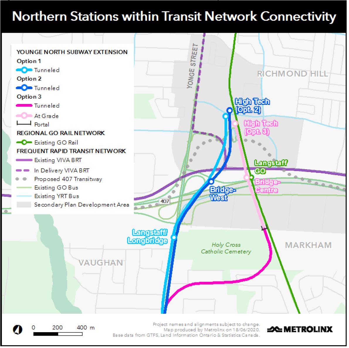
Cutting one of the stations will not bring in the money needed to fund any of the other things being cut. The money you save cutting one of the stations is probably negligible, and considering that the purpose of High Tech is to serve some northern developments, I have a strong feeling that is going to be funded mostly by York Region. The province really doesn't have much interest in funding it since their only mandate is bringing the line north to connect it to the 3 main viva routes, their go bus routes, and that's it. The fact that High Tech is being built is more indicative of Regional pressure than anything.Probably. YRRTC was definitely meddling in the previous plan, and is the reason why we have the ridiculous station name VMC. Wonder what names will come out of this extension.
And if the Prov is keen on saving money by omitting stations, then consolidating Hwy 7 into one is a way of doing that. RHC-LG is a single growth centre, let's see a single station.
Unlike York Region, they've never pushed for a TTC extension.When does Mississauga get the subway they deserve.
Unlike York Region, they've never pushed for a TTC extension (that would be quite the convoluted route).When does Brampton get the subway they deserve.
They are getting the one they want with this extension, so 2030 give or take. Maybe they'll want more after that.When does Richmond Hill get the subway they deserve.
The subway we deserve more than any other is the DRL. From 1983 when it was revived by a suburban politician (yes, it's true) after lying dormant for years and then being a feature of the TTC's 'Network 2011' plan in 1986, the DRL did not become official council policy until 2012.When does TORONTO get the subway we deserve?

 stevemunro.ca
Doesn't that tie into the assumption of line 5 bringing massive ridership increase along the Eglinton corridor?That's before Crosstown line opens though. I expect that to change.