News   GLOBAL  |  Apr 02, 2020
 8.8K     0 
News   GLOBAL  |  Apr 01, 2020
 40K     0 
News   GLOBAL  |  Apr 01, 2020
 5K     0 

Which transit plan do you prefer?

  • Transit City

    Votes: 95 79.2%
  • Ford City

    Votes: 25 20.8%

  • Total voters
    120
Are malls such a great trip generator? If they are why doesn't Yorkdale station have vastly more riders than the others along the Spadina line? Or why don't the buses to Sherway have much higher ridership? Suburban malls are fundamentally car oriented developments, and even great transit won't do much to change that. Moreover, traditional malls are becoming somewhat archaic. Today it is big box power centres that people prefer to shop at and developers like to build. STC is still doing fine, but if current trends continue, where will it be in 20 or 30 years?

As to concentration vs. density, I don't really see how it matters. What I feel matters is how many people are within walking distance of a subway station. If a station serves only a single tower with 1000 people surrounded by parking lots or serves 500 houses each with 2 people the total ridership won't be much different, if the demographics match.

I also think you're very wrong that Toronto's pattern is one of concentrated nodes. Outside of downtown it's really quite even. As the numbers posted earlier show there are only about 60,000 workers in the outer nodes, and 700,000 workers outside the core but not in nodes. Residential patterns are similar.

Yes, malls are great trip generators. Yorkdale has next to no TTC routes feeding it. It doesn't have buses on Lawrence or Wilson dumping like 15,000 people a day into the station. It has the mall. Sherway is not on a subway line and the bus connections are less than ideal. Square One, on the other hand, has great bus connections. "Archaic" Yorkdale is planning yet another wing. Big box stores can easily be built in malls. The new trend of mini Asian-inspired condo-malls is interesting. This stuff is all incredibly obvious.

In 30 years, maybe STC will do something like what the Don Mills Centre did - revamp itself and redevelop and probably generate even more trips than it did before. Oh, what a terrible thing that would be!

I agree, you don't see the difference between density and concentration. STC is concentrated even though you can tweak density figures to make it seem not dense. 1000 people on top of the station is better than 1000 people in houses that spread out over a longer distance. Within a 5 minute walk of STC, there's room for a massive amount ot redevelopment, and that is slowily taking place. Within a 5 minute walk of a station near 500 houses, there's room for nothing because it's a stable neighbourhood.

You must have never been to Toronto if you think the dominant pattern isn't one of nodes and clusters. Half the people in the 416 probably live on 10% of the land due to the concentrations. Sometimes it's just a cluster of a few thousand people, but there are a lot of clusters. There are a lot of small job clusters, too, of 5K or 10K or 20K jobs. You're cherrypicking and then misinterpreting those employment figures. It's not like we're talking about building nothing but one line from NYCC to STC that makes no stops along the way.

Look at this employment map:

2718295888_698acc601f_o.jpg


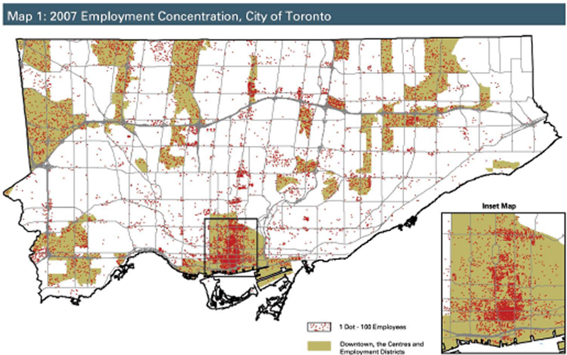
Consider a Sheppard line from Downsview to STC. Look at the job clusters it would serve...jobs in Agincourt, Consumers, Fairview, the hospital, etc., none of which are included amongst the fabled suburban centres employment figure. Then add a DRL going up Don Mills. That hits downtown employment off the YUS line and helps string together some of the big job sites along the DVP. Two lines plus the YUS and B/D line would bring rapid transit to just about every major employment area that can be well-served by rapid transit. Throw in the Spadina extension, extend Bloor a little bit, maybe even add Eglinton (for the east...there's nothing in the west). That would hit practically every significant cluster of jobs in the city.

You would need $50 billion worth of LRT lines to hit the scattered jobs that remain (industrial parks, high schools, strip plazas, etc.) and that $50 billion is wasted unless there's a rapid transit network to tie it all together. There may still be a few hundred thousand jobs scattered all over, but they're almost impossible to reach in any quantity with rapid transit. The Finch LRT could support employment sites better if it was extended south of Humber to Woodbine/Pearson. If an industrial park extends from Finch to Steeles, something on Finch would be useless to jobs near Steeles. A line on Steeles would be useless to jobs near Finch. A third line would be needed on a north/south road to get people close enough to walk.

You're right about malls not being great trip generators. People who shop don't want to drag their bags home on the subway if they have access to a car and free parking. Most of the trip generation at Yorkdale or SCC is probably park-and-ride or teens going to hang out at the mall. However malls have great potential. They hold onto large swaths of land until the market is right for them to redevelop. Anyone remember the Warden Woods Mall at Warden and St.Clair. It's now a transit oriented development. That on a much larger scale will happen to SCC one day. Yorkdale may take a lot longer to evolve.

You're wrong. Do you think all those people at Yorkdale station are connecting to the GO bus? Ever seen the walkway from the transit terminal to the mall at STC? Who cares if some of this is mallrats...duh, they're still taking transit to the mall. More people will park/kiss'n'ride at a mall - that's a benefit of malls, not a bad thing. Also, they keep generating trips on weekends and holidays when offices and schools shut down. Their parking lots can be redeveloped. It's all good.
 
You might consider it obvious that malls are great trip generators, but the numbers suggest otherwise. Yorkdale is the 5th largest mall in Canada, but it's subway station is only the 35th busiest on the network. It might not have as many TTC feeder routes, but is home to a major GO and Greyhound bus terminal and has a large park-and-ride lot. Sherway's poor transit access is more a symptom than a cause. It has poor transit access because few shoppers want to take a bus to the mall. If thousands of riders were wanting to take transit to the mall, there would be more and more direct routes going there. Certainly if you make a mall a transit hub, like Square One, it will become a much travelled to destination. But what percent of those people are getting a connecting bus rather than going to the mall?

That map of employment is somewhat misleading. Each dot is 100 workers, but sites with 100 or more workers are mostly office towers or factories. The majority of workers in Toronto work in neither such place. Consider Ward 18, on the map it looks like a blank area, but there are over 25,000 jobs in that ward. Far more than a much denser looking area like Consumers Road, which only has only 15,000 jobs. Ward 32, down in the Beaches where I live, also looks like a blank area. But there are 15,000 jobs there spread out among many small businesses. This applies to Elginton West as well, there is are an enormous number of jobs along there, but they tend to be small businesses and service sector, not the industrial areas that generate dots on that map. This pattern is true across Toronto, and that map makes no account for them. Moreover, the suburban employment districts you are basing our future transit system around are mainly industrial. As anyone who's been following the news for the last while knows, we should perhaps not expect many of those jobs to be there in the near future.

Here is a map that links to data on all of Toronto's 32 employment districts. In total these areas, that cover a pretty large swath of the city, have 400,000 jobs. Downtown also has about 400,000 jobs. That still leaves 500,000, or about 40%, of all Toronto jobs in the areas in between. With the exception of downtown, Toronto's workers are not at all concentrated and a node based transit system makes no sense for our city. Relying purely on subways will give us a system that is overbuilt where they exist,and underbuilt everywhere else.

Your fantasy system also leaves out some of the largest of these areas as well (such as Rexdale with 45,000 workers). Here is a full lit of workers in 2007 at each of these areas:
Rexdale - 45,000
Bermodnsey - 6,700
Consumers - 15,000
Golden Mile - 12,000
Tapscott - 31,600
Milner - 13,500
Coronation - 1,099
Milliken - 7,342
Steeles - 14,000
Wexford - 7,361
Dorset - 16,000
Progress - 5,300
Railside - 3,284
Danforth - 4,500
Don Mills - 11,721
Leaside - 8,500
South Riverdale - 8,000
Liberty Village - 7,400
Lawrence/Keele - 8,636
York Mills - 17,500
Orfus - 8,373
Downsivew - 9,500
Dufferin/Finch - 31,000
400/Finch - 28,200
400/401 - 6,900
Weston - 2000
Junction - 15,000
Park Lawn - 3,800
Lake Shore - 14,800
The West Mall - 4,640
Central Etobicoke - 19,000
Claireville - 14,400
 
You must have never been to Toronto if you think the dominant pattern isn't one of nodes and clusters. Half the people in the 416 probably live on 10% of the land due to the concentrations.

This claim can be checked by looking at the census data. Toronto covers 630 km2.If we take only the densest 63 km2 of census tracts, the population is 730,000, or about 30% of the total. To get to your 50% of the population, we have to get to 141 km2, or 22% of the total.
 
Maybe the TTC and the City should focus on getting developers to build near current or plan subway lines rather than having the developers dictate where they want to build and the TTC comes in later to build subway lines. Most of the subway development costs are due in fact or moving existing utility lines around and building tunnels with little disruption to business above.
 
If you don't think the ridership to STC justifies a subway extension, then you're basically saying there's no subways to be built in Toronto at all (never mind the Spadina extension, hem hem)

My idea of a Hurontario subway? Get your reading comprehension cap on drum118. I dismissed a subway as unneeded and I specifically stated all we need is an LRT. I've posted many times about how Mississauga would take any LRVs that Ford doesn't want. Pay attention drum118.

Which basically says that LRT is fine for Sheppard.

I disagree. Why is it worth an extra 600 Million to convert the SRT LRT to SUBWAY so that there wont be SUBWAY transfer at KENNEDY.... BUt Spending 600 Million to convert the Sheppard Subway to LRT to eliminate the transfer doesnt make sense.

ITS WORTH 600 MIlLION because people HATE HATE HATE HATE transfers.

That sounds so silly and stupid. But its the truth. People hate Transfers and less transfers causes more riders or at least less rider frusteration.

Converting Sheppard would be a way of cutting our losses before it becomes a huge endless pit. Converting SRT would be because its usage today would likely dwarf that on Sheppard two or three generations from now.
 
...
That map of employment is somewhat misleading. Each dot is 100 workers, but sites with 100 or more workers are mostly office towers or factories. The majority of workers in Toronto work in neither such place. Consider Ward 18, on the map it looks like a blank area, but there are over 25,000 jobs in that ward. Far more than a much denser looking area like Consumers Road, which only has only 15,000 jobs. Ward 32, down in the Beaches where I live, also looks like a blank area. But there are 15,000 jobs there spread out among many small businesses. This applies to Elginton West as well, there is are an enormous number of jobs along there, but they tend to be small businesses and service sector, not the industrial areas that generate dots on that map. This pattern is true across Toronto, and that map makes no account for them. Moreover, the suburban employment districts you are basing our future transit system around are mainly industrial. As anyone who's been following the news for the last while knows, we should perhaps not expect many of those jobs to be there in the near future.

Here is a map that links to data on all of Toronto's 32 employment districts. In total these areas, that cover a pretty large swath of the city, have 400,000 jobs. Downtown also has about 400,000 jobs. That still leaves 500,000, or about 40%, of all Toronto jobs in the areas in between. With the exception of downtown, Toronto's workers are not at all concentrated and a node based transit system makes no sense for our city. Relying purely on subways will give us a system that is overbuilt where they exist,and underbuilt everywhere else.
...

You're comparing Ward 18 which is 5 square km's and employs 25 000 people to consumers which is 103 ha (roughly 1 square km) and squeezes out only 15 000 jobs. At one fifth the size but three fifth's the jobs I'd conclude that consumers is far more dense than ward 18. I fail to see how this illustrates a flaw in the information provided by the map.
 
This claim can be checked by looking at the census data. Toronto covers 630 km2.If we take only the densest 63 km2 of census tracts, the population is 730,000, or about 30% of the total. To get to your 50% of the population, we have to get to 141 km2, or 22% of the total.

You just proved Scarberian's point. He was making a generic argument. Good for you for providing specifics.

You just showed that population distribution is non-linear. If half the people are using only 22% of the land, and not half the land, it stands to reason that they live in nodes and clusters of nodes, not nicely spread out throughout the city.
 
This claim can be checked by looking at the census data. Toronto covers 630 km2.If we take only the densest 63 km2 of census tracts, the population is 730,000, or about 30% of the total. To get to your 50% of the population, we have to get to 141 km2, or 22% of the total.

Census tracts are a terrible choice for proving or disproving Scarberian's point. It's far too coarse of a level of spatial aggregation. Many census tracts include large sections of uninhabited land, bringing their densities down.

Probably the best choice would be to use dissemination blocks, but since I don't have access to that data, I'll do the same analysis using dissemination areas.

With DAs, the densest 10% of Toronto contains about 963,000 people, or about 38% of the total. To get to 50% of the population, we would need to count less than 16% of Toronto's total area.

I'm pretty confident that using dissemination blocks for this analysis would push the results in to "half the population on 10% of the land" territory.
 
You're comparing Ward 18 which is 5 square km's and employs 25 000 people to consumers which is 103 ha (roughly 1 square km) and squeezes out only 15 000 jobs. At one fifth the size but three fifth's the jobs I'd conclude that consumers is far more dense than ward 18. I fail to see how this illustrates a flaw in the information provided by the map.

Simon is confusing labour force with employment counts. Ward 18 has 10,000 jobs and a labour force of 25,000. That kind of matters when you're claiming "density" is so important. Every neighbourhood is going to have a certain minimum number of jobs if only due to elementary schools and corner plazas. Ward 4, for instance, through which will plough a long stretch of the Eglinton line, has only 5,000 jobs, and only a fraction of these are near Eglinton. "Enormous number of jobs"? Rubbish.

I can easily refute everything else he claims, but I don't have time now. For now, though, what on earth will Transit City do for Ward 18 or Ward 32? Why does the presence of a modest number of jobs on mixed-use streets like Bloor and Queen mean we must only expand transit with light rail lines that each cost over a billion dollars? How many of the jobs in those industrial parks Simon lists are actually within walking distance of a line like Finch West or Sheppard or Eglinton? What if you live or work on Steeles or Lawrence? Oops, you get nothing.

Technically they would get worse than nothing, as the bus service on parallel routes will likely be reduced, because some of the ridership will shift to the new TC lines. For example, if you're halfway between Eglinton and Lawrence, are you going to take the bus up to Lawrence, or the bus down to Eglinton? Before, the split was probably close to 50/50 (depending on time of day, destination, etc). That split is going to drastically change if there's an underground LRT along Eglinton. That will in turn affect ridership on adjacent parallel routes.
 
The proper grain for determining relative density is a difficult issue. Finer isn't necessarily better. To take it to its furthest extend, at any one time each person takes up about one square meter of space. That means you could fit all 2.5 million Torontonians into only 2.5km. Less than 1% of the city's surface area! Of course this is nonsense. If we're talking about subway stations, we should be using a measure roughly equal to walking distance from the station, about a 500m radius. Census Tracts are close to this, though not perfect.

Sorry, yes I did confuse the numbers on the Ward 18 page. But 10,000 jobs is still not nothing. I agree that Ward 4 does not have enough jobs or people to justify any sort of higher order transit. The only reason to consider putting a line through there is to get to the airport. Veering north and hitting the Rexdale industrial areas in Ward 2 would hit 50,000 jobs. But even these aren't a great transit priority, they are easily accessible by car, ringed by major highways, and have plenty of parking which I imagine is free for the workers at most places. Many of the workers are also likely coming from the west. Even with a subway to the door what percent of those workers would take transit?

The same argument applies for the industrial zones in northern Scarborough. Many of the workers are coming from Markham or Pickering and the transit would be of little help. There is plenty of parking, and the 401 makes them car accessible. Jobs in other areas are very different. Along Eglinton West, parking is far more rare and expensive. Most people who work there live on other parts of the TTC network, and the highway access is far worse. Put a subway there, and you might get close to downtown ratios of people commuting by transit.
 
Last edited:
For now, though, what on earth will Transit City do for Ward 18 or Ward 32? Why does the presence of a modest number of jobs on mixed-use streets like Bloor and Queen mean we must only expand transit with light rail lines that each cost over a billion dollars? How many of the jobs in those industrial parks Simon lists are actually within walking distance of a line like Finch West or Sheppard or Eglinton? What if you live or work on Steeles or Lawrence? Oops, you get nothing.

Transit City will not benefit everyone, but going with subways means an overbuilt system for some and nothing for many. Far better to build a properly scaled system for many.
 
Scarberian, I know you weren't part of the SaveOurSubways crowd - ultimately you'd prefer the city just focus on express bus routes and improved service in the northern part of the city and the DRL, correct?
 

Back
Top