That mirrors my experience, although I counter-commute at rush hour, I normally only have to wait a station or 2 to get a seat. Going downtown at rush hour I've only passed up a train once.
It has all its funding lined up ($1.283 billion Provincial, $1.283 billion Federal, $100 million municipal, $2.67 billion CdP), which is impressive enough. The DRL has been on the books forever and all they were able to fund is studies.
The contracts were supposed to already be issued and a bidder selected, but that has been delayed "until the end of the year." Supposedly that doesn't impact the timeline.
There was a court challenge launched in March over the fact that the BAPE results were ignored and consultations rammed through.
I think that judge has been hearing arguments over the last two weeks, but I don't know if it has gotten anywhere (maybe this lawsuit is why the tender was delayed?)
In terms of significant design changes, it has already had a few, the biggest
being the addition of 3 "optional" stations a year ago, which were really the 3 most useful/expensive stations which allow you to connect with other Metro lines, instead of the REM being completely self-contained. Edouard Mont-Petit will be very interesting, since it is so deep below the existing station and they will need to build high-capacity elevators. McGill station will be a great addition, right in the heart of downtown connecting to the Eaton centre, McGill university, a number of financial hubs, etc.
The rest of the changes have been fairly minor.
This article gives a description of the timeline.
Personally, I'd like to see them make a few more design changes (note, many of these images are taken from
Anton Dubrau's BAPE deposition)
1) Change the south downtown alignment to improve coverage
The current alignment just has a single, underwater station at Peel basin, with exits at both ends, to serve Griffintown and Point Saint Charles. This isn't great because 1) it's expensive, 2) it means that Ottawa street, which was slated for BRT, will have to be closed and 3) the ridership potential at Du Havre station is very limited because it is a sliver of incredibly toxic land in between a railyard, highway, and river.
View attachment 129459
If instead of being tunneled, the REM were elevated using the existing rail viaduct (which has room), you could have separate stations to service Griffintown and Point Saint Charles, maintain Ottawa street for BRT, and have a better catchment area. This would also avoid
tunneling through incredibly contaminated land.
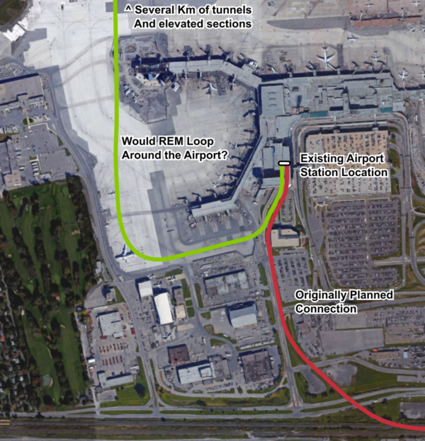
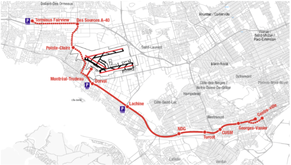
2) Connect to the airport from the south instead of the north
The current connection involves tunnelling under an active runway, when the airport is only 500 meters away from a railway. There is a pre-built station in the airport, which is pointing south (the logical direction for a connection)
By going south you could avoid all that tunneling, which is the most expensive part of the REM route and also one of the lowest ridership sections.
If the desire is to have
the airport connection as part of the REM and not as a stand-alone line, I see two options that would cost about the same but would provide much better coverage:
Option A: Turcot/CN routing
This is more or less the routing originally anticipated by the ADM study (which was also supposed to be SkyTrain), but now it's able to connect with the REM at Point St. Charles instead of terminating at Central station. The 2010 study priced this alignment at $1.1 billion. The benefit to this alignment is:
1) It provides coverage to many new areas while being almost entirely above ground.
2) The province has already spent $136 million reserving space for a train along the Turcot corridor, currently under construction.
The disadvantage is that it is a bit indirect, and it awkwardly serves Ville Émard/NDG because it wedged between the St. Jacques Bluffs and a highway.
CP/Pink line routing
View attachment 129463
I've drawn the fantasy map above to show what is under consideration. It's a combination of the AMT "Train de l'Ouest" proposal and Phase II of Projet Montréal's Pink line. The idea is that the CP ROW would be used, which is on top of the Bluffs and much closer to where people live. Rather than terminate at Lucien L'allier (like the AMT proposal) or continue northeast (as part of phase I of the pink line, which is unlikely to be built anytime this half century) it would be a branch of the REM from downtown. This way, we would be doing the tunneling in places that make sense (downtown, under Rene-Levesque) instead of under a runway. Tunelling may not even be necessary, since there is extra room in the decked-over Ville-Marie expressway.
The REM vehicles would allow for new stations in NDG, including one at Cavendish (very useful connection, especially with the Dalle-parc cyclist/pedestrian connection south to Ville Emard and the planned Cavendish extension north at Cote-St-Luc.
The advantages is that this serves many population centers and destinations, and is a much more direct route downtown than the REM routing. The disadvantages are the unknowns about the shared ROW with CP/AMT, and how the tunneling (if any) would be done downtown.
3) Move the west island branch north and bury it with the hydro lines
View attachment 129464
I'm not completely sold on this change, but the idea is that the current middle-of-a-highway alignment isn't great because A) nobody lives next to a highway so almost all the ridership is from Park n rides, B) densification is almost impossible (and not desireable because of pollution/noise) next to a highway and C) the station locations result in lengthy bus tours.
If the west island branch were built along the hydro corridor, it could be trenched and decked over, and combined with a proposed burial of power lines. Then it would be much closer to where population centers are, you could have intensification along the corridor, and the stations would be directly under north/south arteries for better bus connections. This would also reduce competition for the Vaudreil-Hudson line, which dies with the REM along with the Mascouche line, and avoids urban sprawl because you get fewer kilometers of rapid transit.
I'm not 100% sold because 1) even though population density is greater along Salaberry, there tend to be more jobs located near highways because of office parks 2) although there exists the potential for densification, west island communities have an awful track record of actually allowing it so you would still end up with SFH next to rapid transit 3) you get less coverage than with elevated transit.


