Posted today:
Request for Quotation
Call number: 9118-16-7085
Commodity: Professional Services, Architectural Services
Description: Non-exclusive provision of six (6) perspective renderings of the Port Lands Framework Plan
Quotations are invited for the non-exclusive provision of six (6) perspective renderings of the Port Lands Framework Plan for the City of Toronto’s City Planning Division, in partnership with Waterfront Toronto. The renderings shall comprise a minimum of one (1) elevated / bird's eye view, a minimum of two (2) aerial views, and a minimum of three (3) pedestrian level views. Base mapping of the street network and building footprints and basic building modelling will be provided to the Vendor in digital format (.dwg and .skp or .3dm). The Vendor shall be required to provide the renderings in both digital and print format.
Issue date: April 18, 2016 Closing date: April 29, 2016
at 12:00 Noon
Scope of work:
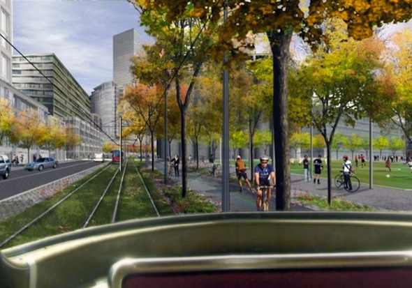
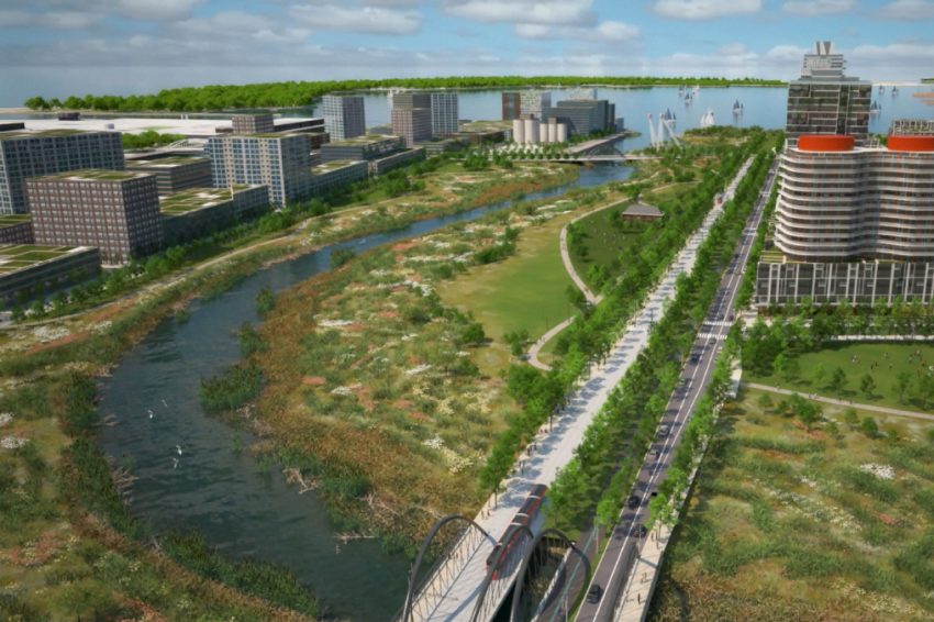
The Vendor shall prepare a minimum of six (6) perspective renderings of the Port Lands Framework Plan, comprising a minimum of one (1) elevated / bird's eye view, a minimum of two (2) aerial views, and a minimum of three (3) pedestrian level views. A visual identity for other graphics and plans, specifically a Demonstration Plan, has been developed. The renderings will build on the palate of the Demonstration Plan to create a cohesive set of graphic materials for the final Port Lands Planning Framework document. The Demonstration Plan is provided in Appendix F for reference purposes.
3.1 Background and Context
The Port Lands is a 325 hectare area of underutilized land located on the shore of Lake Ontario in close proximity to Toronto's downtown. Created through lake filling for port related uses in the early 20th century the Port Lands are currently home to many commercial, industrial, film/creative and port dependant industries, as well as numerous heritage resources. The Port Lands represent an unprecedented redevelopment opportunity for the city and the Port Lands Framework Plan will guide its revitalization and redevelopment over the near, medium and long term. The plan applies to an area bounded by the Keating Channel and Lake Shore Boulevard East to the north, Leslie Street to the east, Unwin Avenue to the south, and Lake Ontario / Toronto's Inner Harbour to the west.
The Port Lands of the future is envisioned as a vibrant part of the city; comprised of unique districts that take their character from surrounding landscapes and wilderness areas, heritage resources, and their waterfront location as well as prevailing land uses. Given the Port lands geographic location southeast of Toronto's Downtown, its future skyline, as viewed from key public destinations along the waterfront, is an important aspect of the planning work underway. Development within the various districts of the Port Lands will be substantial enough to lend definition to the public realm, organized to locate animating uses adjacent to public spaces, and massed to provide sensitive transitions between new development and heritage resources.
3.2 Base Materials
Prior to preparing perspective renderings, the Vendor will be provided with the following mapping and modelling in digital format (.dwg and .3dm or .skp):
• Base mapping of the planned street network, proposed building footprints and the naturalization of the Don River.
• Basic massing model (see Appendix X) of existing buildings in the Port Lands and surrounding areas as needed, and conceptual built form massing for new districts. The massing model does not have the necessary building detail or architectural articulation that the Vendor will be required to prepare for all conceptual buildings. The massing model has also not integrated regrading that will occur as part of the construction of the river. The perspective renderings should graphically convey the topographic changes contemplated.
For more information on this call, please click on the viewing copy attachment in the Notes section above.


")