News   GLOBAL  |  Apr 02, 2020
 8.9K     0 
News   GLOBAL  |  Apr 01, 2020
 40K     0 
News   GLOBAL  |  Apr 01, 2020
 5.1K     0 

They are talking about burying them in VMC, but they don't bury them as doing so would increase costs of the project by something like 30%. That's a big price to pay to get rid of a couple of wires.

Well other places are willing to pay that price to get rid of them and beautify up their cities. As usual in Toronto, we are clueless.
 
I know this has been debated to death, but as long as this practice continues in the GTA people are going to keep complaining.

Well they buried the wires on St Clair (with great cost and delay) and some people are still complaining about that.
 
Well they buried the wires on St Clair (with great cost and delay) and some people are still complaining about that.
A lot of concessions were made to the anti streetcar right of way people that added costs and delays. The street looks much better than it used to and burying the wires was well worth it, imo. Most cities would bury wires on that kind of street without a second thought, let alone controversy.
 
They couldve at the very least used something else than the tree trunks that are used right now. I was at a suburb in Chicago last year and they used white steel posts that were taller than these trees for their lines
on the main street. IMO aesthetically looked much more modern and in this case would fit in better with the streetscape
 
probably done that way because of the ways the various agencies are set up. Power Stream likely didn't want to pay for maintenance on metal towers if Metrolinx or York Region asked for them, which means that you end up with the traditional wood towers.
 
Why on earth have they torn up the hwy 7 rapidway after only 2 years of service? Seems to be a tremendous waste of money since there were no visible cracks on the road surface.....was a fundamental flaw on the road surface identified or is it "surplus" money being spent just because......? Crazy.....
 
I asked them. They said their inspections found "deficiencies" and that this work is covered under warranty.

One thing that they need to replace system wide is the tactile strips on the platforms. Unlike the TTC which uses some sort of rubber material, the vivastations use some type of a ceramic. They're chipping like crazy. I see chips every now and then, tap it with my foot and sometimes the entire chunk just comes right out of the ground with little to no pressure from my foot. I can't imagine how these tiles are going to hold up to snow removal machines if they can't even handle my foot.

They need to replace it with some rubber compound.
 
I noticed today that there were a number of locations along the roadway that had the words 'loop' painted (on the old sections). Maybe for the installation of vehicle detection loops? Hopefully this means better signal priority for the buses.
 
Highway 7 West (Weston Road-GO Newmarket Sub) update, 15 October 2016:

Work is largely complete for the rapidway. The only part remaining under construction is the station at Vaughan Centre. It must be frustrating for YRT, because until the subway extension opens there won't be any Viva service along this segment of highway 7. I wonder if they'll reroute route 77A Highway 7 Express along it, simply to make use of the new infrastructure. That route operates non-stop between Edgeley/Interchange Way and Yonge.

There is now a very brief opportunity to comfortably ride a bicycle along Highway 7, because the motor traffic lane adjacent to the bike lane is blocked off. Once those pylons are gone, it will be absolutely terrifying to use these bike lanes. Even with a 50 km/h construction zone limit, cars seemed to be going 70+ km/h.
30279629661_3c3191bc02_b.jpg


Looking westbound at Keele. This "Turning vehicles yield to bicycles" sign has been carefully placed directly behind a tree.
30279620421_1bfa0d3eec_b.jpg


The new bus stop at Vaughan Centre station looms large as you head down Highway 7. It's very impressive! I knew there would be a full canopy over the Viva stop, but I didn't realize how enormous it would be!
30365749295_9e1aa5d5cf_b.jpg


Construction workers for scale:
30365739295_9b46e18cc1_b.jpg


30249046392_5fcf693ba9_b.jpg


Looking eastbound at Maplecrete, a new traffic signal is installed.
30365713725_e45452bc63_b.jpg


Looking eastbound at Creditstone:
30249022362_f608b0caff_b.jpg


Looking eastbound at the CN MacMillan Yard overpass:
30365691935_a00890be08_b.jpg


Looking eastbound at Keele:
30249001932_d7a3ae8110_b.jpg


Looking eastbound from east of Keele:
30330396456_ccacc68f77_b.jpg


At the underpass under the Metrolinx Newmarket Subdivision (GO Transit Barrie Line), the amount of right-of-way available decreases. The number of bus lanes drops from 2 to 0, the number of bike lanes drops from 2 to 0, and the number of sidewalks drops from 2 to 0. The number of car lanes stays constant at 6.
30279641151_d333869785_b.jpg


To add insult to injury, there is 2 metres of unused space in the middle of the road under the bridge.
30279518781_c508fdf25c_b.jpg


I was thoroughly unimpressed with the two-stage crossings on the west end of the project site, where the median is between the two bus lanes. Where there is a bus stop, the median is offset so the Flashing Don't Walk is longer, since it needs to accommodate the longer crossing. In that case, I could just make it across in one cycle if I hurry. But the main issue is that there's actually a much longer time within the cycle during which one half of the two-stage crossings could display Walk. I wrote a whole blog post explaining why:


https://ontariotrafficman.wordpress.com/2016/10/16/neglecting-pedestrians-in-vaughan-centre/

This afternoon I visited Vaughan Metropolitan Centre to see the progress in one of the largest urban transformations underway in Ontario. The City of Vaughan, with a lot of help from York Region and the Province of Ontario, is turning a big-box commercial area best known for Ikea and Wal-Mart into a high-density mixed-use centre featuring highrise office and residential towers. The hub of the development is Vaughan Centre station, which will be the interchange between the Toronto Transit Commission’s Line 1 subway and York Region Transit’s Viva Purple bus rapid transit line.

I was impressed by a lot of the transit infrastructure I saw, especially Vaughan Centre station. I was also happy to find a relatively pleasant pedestrian environment along Highway 7 for such a busy and high-speed road. But my pleasant experience was abruptly ended when I decided to cross Highway 7 to head back along the other side of the road.

Because it took me almost four minutes to do so.

I crossed at Highway 7 & Interchange Way, which is the western edge of the current road reconstruction project. This intersection is one block away from the Vaughan Centre subway station set to open at the end of 2017, so the number of pedestrians will be rapidly growing over the next few years.

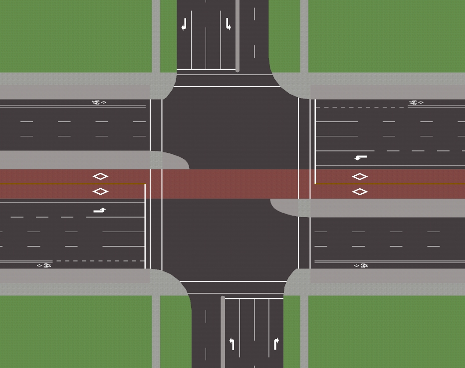
Here’s the rough layout of a standard intersection along Highway 7, oriented normally so north is up. Highway 7 & Interchange Way has a slightly different median arrangement, but it’s generally consistent with this diagram.


In the video I walk from southwest corner to top northeast corner along the west side and north side crossings. The north-south crossings are two-stage crossings, meaning that there are separate pedestrian signals for each half of the crossing. Pedestrians have a whopping 43 metres to cross, including 7 general purpose lanes, 2 bus lanes, 2 bicycle lanes and a wide median which at some other intersections includes a bus stop.

The phase sequence is as follows:


Phase 1/5: East-West Left & North-South Right


Phase 2/6: East-West Through


Phase 3/7: North-South Left (at Interchange Way there is no southbound left turn phase so this is actually phase 3/8, shared with northbound thru)


Phase 4/8: North-South Through

The missed opportunity here is phase 3/7. Cars are crossing turning left across one of the halves of the north-south pedestrian crossing, but since there are no right turn lane for eastbound traffic, there is no eastbound right turn arrow. All east-west traffic sees a red display, so the walk light for that half could overlap with this phase. And since it is always followed by phase 4/8, it could stay in Walk for the entire duration of phase 3/7 – that phase could still be vehicle-actuated.


Half of the north-south pedestrian crossings could overlap with phase 3/7.

After all, given that we have two-stage pedestrian signals, we might as well get some benefit from them.

In the video, if the Walk indication for the first half of the crossing had started along with phase 3, I would have been halfway through the second half of the crossing by the time the Flashing Don’t Walk began, easily crossing Highway 7 in one go. This would have saved me a whopping 2 minutes of delay, as you can see from the other pedestrians who realized the pedestrian signals were lying and started walking during the middle of phase 3/7.

The likely reason that the pedestrian signals don’t overlap with phases 3/7 is that like almost all other signals in York Region, this is a Semi-Actuated Type 2 (SA-2) intersection. That means that the Walk light for the side street is only displayed if someone pressed the button. Managing pedestrian calls with overlaps and callable phases would get complicated, and I guess York Region would just rather not bother.

But given that the side street is busy enough to warrant a left turn phase, there must also be enough traffic that putting the pedestrian signal recall wouldn’t have much impact. To accommodate the volume of motor traffic, side street green will be fairly long regardless of whether a pedestrian presses the button. So the walk light might as well come up every cycle. Then it would be very simple to set up pedestrian overlaps for one of the north-south pedestrian stages.

Pedestrian traffic is the lifeblood of any urban centre, so if Vaughan and York Region want their new development node to be more than just a traffic jam, they should start considering the pedestrian experience in the traffic signal timings.
 
Last edited:
That underpass is such a huge waste. After getting so creative under the 404 on Highway 7, they go and waste it under the Barrie Line rail corridor by not putting in a sidewalk when they very easily could have. To add insult to injury, Vaughan is planning a significant amount of density on the east side of the rail corridor and there will be people who want to walk west to the restaurants on the north side of Highway 7 who will be unable to. Agreed on the two stage crossing being crap.

The bus lanes will be used, but the buses will exit the lanes at Jane and continue in mixed traffic around the future subway stop. The part between Edgeley and Jane will open with the subway.
 
That Vaughan Centre stop is huge. I saw it in person the other day..

Will the overpass for the Barrie line be replaced as part of the RER?
 
They should definitely tunnel through the overpass to build sidewalks and use the centre lane as a two-way gauntlet for the rapidway like at the 404.
 
Agreed on the two stage crossing being crap.

My point wasn't just that they're crap though. I knew they were crap going in. My point is that they're pointlessly crap. What I hadn't realized is that there is already enough time within the cycle to cross the street in one go, it's just not displayed on the pedestrian signals.

The bus lanes will be used, but the buses will exit the lanes at Jane and continue in mixed traffic around the future subway stop. The part between Edgeley and Jane will open with the subway.

Used by what route? Currently there is no Viva service on Highway 7 between Edgeley/InterchangeWay and Keele.
 
That underpass is such a huge waste. After getting so creative under the 404 on Highway 7, they go and waste it under the Barrie Line rail corridor by not putting in a sidewalk when they very easily could have. To add insult to injury, Vaughan is planning a significant amount of density on the east side of the rail corridor and there will be people who want to walk west to the restaurants on the north side of Highway 7 who will be unable to. Agreed on the two stage crossing being crap.

The bus lanes will be used, but the buses will exit the lanes at Jane and continue in mixed traffic around the future subway stop. The part between Edgeley and Jane will open with the subway.

well to be fair, the traffic at this area isnt as bad as 404....most of the time traffic is pretty smooth until you reach Keele even during rush hour. By that time youre already in the ROW. Besides, its really only for a small stretch anyways (1km max) the ROW continues once you turn into Dufferin
As for the bike lane, I dont think the usage really warrents this at this time. There is virtually no development in this area and the few bikers that are from the single detached homes further down towards dufferin and bathurst wont likely bike on this stretch anyways because of the high avg speeds of surround traffic.
 

Back
Top