News   GLOBAL  |  Apr 02, 2020
 9.5K     0 
News   GLOBAL  |  Apr 01, 2020
 40K     0 
News   GLOBAL  |  Apr 01, 2020
 5.4K     0 

bypass lanes would make the road prohibitively wide. Its already 9 lanes wide...11 lanes is just too much.

I guess you probably answered your own question on the second part. Though deleting the right turn lane was a mistake imo....yrt buses are a pain during morning rush when they have to stop to take on/let off people
Technically it's already 12 lanes wide at Keele St. It has 6 through lanes, 2 left turn lanes, 1 right turn lane, 2 bus lanes, and 1 platform that takes up 1 lane.

I agree that YRT buses are annoying from the absence of right turn lanes at most intersections, and they also make it disruptive when a car turning has to wait for pedestrians and hold up traffic behind.
 
I totally applaud York's efforts on improving transit and giving it ROW but it has so many stops and service is so infrequent that the "rapidways" don't seem to live up to their name.

It stops just as frequently as all of the proposed LRTs in Toronto would
 
September 14:
IMG_1996.JPG
IMG_1997.JPG
IMG_1998.JPG
 

Attachments

  • IMG_1996.JPG
    IMG_1996.JPG
    3.2 MB · Views: 483
  • IMG_1997.JPG
    IMG_1997.JPG
    2.8 MB · Views: 493
  • IMG_1998.JPG
    IMG_1998.JPG
    2.7 MB · Views: 422
September 14:
that was quick....a few days ago when i last was there there were no studs.... though by their curb design for the perimeter it does appear that there are no plans at this time to further enclose the terminal.....
I guess theyre banking on a long term plan to relocate the entire terminal to the future RHC subway terminus
I thought the terminal was to remain at the same location when the subway gets built. It is suppose to only be expanded above ground or underground. They can always expand the terminal and then rebuild the existing sections to be enclosed.
 
They will demolish the Silvercity and put the new terminal there once the subway gets built. This one is "temporary".

Even if the subway gets funding tomorrow however, it would still get at least another 10 years of use.
 
They will demolish the Silvercity and put the new terminal there once the subway gets built. This one is "temporary".

Even if the subway gets funding tomorrow however, it would still get at least another 10 years of use.
According to the EPR, page 111, Silvercity will remain in place, and the bus terminal will be rebuilt with a 26 bus bay stacked terminal.
 
The subway platform is directly below silvercity, and it places a PPUDO right in the middle of the building. The Silvercity is getting demolished.
 
Does anyone know how the Highway 7 Rapidway will connect with RHC from the east? I've seen somewhere that the RHC plan is to extend Garden Ave from Yonge to Bayview, where both connect to where the connector roads are and the Rapidway either runs within or beside the said road extension. Is this correct or is it not planned yet?
 
it'll use the existing highway 7 accesses, at least in the short term.

There is a high level master plan for the area with a bunch of new roads, but most of that is very far off. The only one that is planned to happen relatively soon I believe is to connect Cedar Avenue under the 407 to High Tech Road. The 407 has had a bridge built over the right of way for decades.
 
You also need frequent stops if the rapid transit you're planning is in a "downtown" or "high density" area.

Streets like Jane, Don Mills, Finch West and Sheppard East aren't any more "downtown" or significantly higher-density than the Viva Purple/Orange corridor.

Does anyone know how the Highway 7 Rapidway will connect with RHC from the east?

The same way it currently does. There's no reason to build bus lanes on that part of Highway 7. There aren't any current or foreseeable traffic concerns and there aren't any stops either.
 
it'll use the existing highway 7 accesses, at least in the short term.

There is a high level master plan for the area with a bunch of new roads, but most of that is very far off. The only one that is planned to happen relatively soon I believe is to connect Cedar Avenue under the 407 to High Tech Road. The 407 has had a bridge built over the right of way for decades.
I am quite aware of the plan to connect Cedar Ave and Red Cedar Ave underneath Highway 7 and 407. It's suppose to be constructed by 2021 costing only $9.2M. The only problem is that only Yonge, Cedar, and Bayview cross Hwy 407 for vehicles, with 1-2 pedestrian/bike crossings.
 
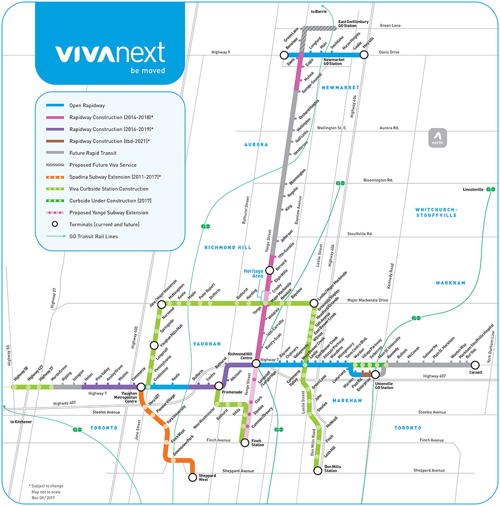
The vivaNext site has updated the project map to show that the Highway 7 Curbside stations between Warden and Kennedy are now under construction in [2017] with no *. Viva Curbside Station Construction has it's [2018-2020] timeline removed. It also shows the Highway 7 West Rapidway from Jane to Barrie GO (the bridge) is now open. Shows Post Rd. stop instead of Market stop. Also the Stouffville Line line looks more accurate and the Barrie Line line actually goes through Downsview Park Station. This one's very minor, the Leslie St jog at Stouffville Rd is now shown :cool:.
vivaRouteMap_web_2017_08_29.jpg

One thing that bothers me is that this still says December 2016 and not Spring 2018:
goIX5oqHQC_GKKJaN1PWcg.png
 
Last edited:

Back
Top