News   GLOBAL  |  Apr 02, 2020
 8.5K     0 
News   GLOBAL  |  Apr 01, 2020
 39K     0 
News   GLOBAL  |  Apr 01, 2020
 4.8K     0 

The CF (or CAF) standardized on 120. It made parades easier if everyone was marching the same pace :) They even taught us Navy (then still officially Maritime Command) officer cadets how to march. We did however have an Army instructor. A long time member of the PPCLI taught us very well. When doing rifle drill one guy dropped his rifle. The master warrant stopped mid stride. "If you EVER drop your rifle, you had better be under it before it hits the ground!" and carried on. One day after a long session in the hot sun he cracks "How about we hum a few bars of 'There's no life like it'?".

Ha. My son is at HMCS Venture right now. I'll have to show him this. He really isn't otherwise interested in Then and Now. :)
 
Once, a whistle-stop town - 1951

aerialdowntownrailyardsc1951cropped_zpse0f5e02d.jpg


Now, construction non-stop - 2009

aerialFortYorkandsurroundings2009x_zps27ff2523.jpg
 
Last edited:
In the old picture you can see Maple Leaf Stadium peeking out on the right side. Too bad that wasn't kept around 9 more years. The Jays could have added an upper deck to it and would've had a retro ballpark decades before Camden Yards!
 
Once, a whistle-stop town - 1951
...
Now, construction non-stop - 2009


I happened to have spent time tracking down the institutional attribution of the first photo.

It is "Aerial view of the Canadian National Railways yard in downtown Toronto. Toronto, Ontario, Canada. 1951". It's held at the Canada Science and Technology Museum, Ottawa: CN002868

A decent (albeit sepia toned) resolution version may be examined here. ps Red October, more of the stadium is visible in this version.

As for the second photo, it was taken by Bernard Dupuis for Wittington Properties.
 
Last edited:
Too bad The City and others didn't do their DD about the Heritage Plan for E W Gillet Co Ltd

and the age of the large photo picture map, among other items of import of the Liberty area.


Regards,
J T
 
Last edited:
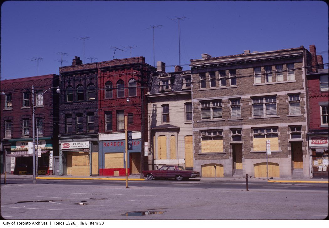
Then.


1970-ish? Church Street. Looking E across to a group of stores being prepared for demolition. Carlton Street is just out of frame to the left.

There is nothing special about the Then picture; or the Now picture.. in my mind, anyways. I don't want to be Captain Obvious here but I thought I would point that many Then pictures in the Toronto Archives were shot just before demolition. The idea being I suppose 'go out grab a shot for posterity before Tepermans shows up'. I've been doing this on my own for a couple of years now... if any readers here have their own 'Then' pictures [excepting Goldie :) ] perhaps we may see them?

1250ViewofboardedupbuildingsoneastsideofChurchStreetsouthofCarltonStreetjun971_zps2b4903b6.jpg


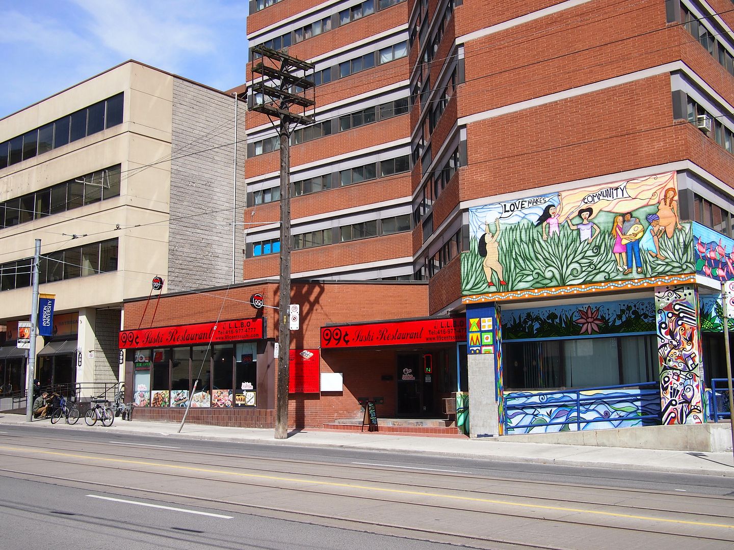
Now. April 2014.

1251_zpsf154ca5e.jpg


Hong Kong Then and Now:


https://www.flickr.com/photos/old-hk/page1/


Documenting the sparsely populated Canadian west. Interesting photo project. Not a Then and Now per se but fascinating.

http://www.citylab.com/design/2014/07/documenting-the-sparsely-populated-canadian-west/375332/


Tunnel vision: how an obsessed explorer found and lost the world's oldest subway.

http://www.theverge.com/2014/2/5/52...diamond-fights-for-the-atlantic-avenue-subway


The Last Glimpses of the Disappearing Film Projection Booth

http://www.slate.com/blogs/behold/2...ction_booths_in_his_exhibition_the_booth.html


As twilight faded over Pasadena on September 9, 1894, an artificial sun flickered to life for the first time.

http://southland.gizmodo.com/this-g...from-a-mountai-1616978277/+kcampbelldollaghan
.
 
Last edited:
Ah, the Studio: one of those classic "70s greasy spoons".

Incidentally, I've wondered whether this residence was originally meant to be extended-in-kind northward; the "abruptness" of the termination on the left suggests such a thing...
 
*Request *

I'm new here to post, long time lurker though

In the 1980's I worked at 185 Bay Street. It was an older office building that was torn down to build BCE place
I would be grateful if someone could post pix of the east side of Bay from Front to Wellington prior to it being demo'd for BCE
There was also an alley way that ran behind the building which ran south off Wellington to loading docks behind that block

As a side note I also worked at 15 Wellington West around that time in a building from 1850'ish I think it was a bank building
The facade was preserved and moved south and erected in east end of the big hall in the BCE.
I have seen a picture of it in the Rossin house panorama

Andrew

1954 - from the James Salmon photo collection on the TPL website
pictures-r-6301.jpg


From the Toronto Archives website - Buildings, Part 3,Ellis Wiley fonds - there's more of that block there
f0124_fl0003_id0111.jpg
 
Also this pic from Salmon, looking down Jordan Street:

wellingtonwestbank.jpg
 

Attachments

  • wellingtonwestbank.jpg
    wellingtonwestbank.jpg
    89.9 KB · Views: 868
Last edited:
*Request *

I'm new here to post, long time lurker though

In the 1980's I worked at 185 Bay Street. It was an older office building that was torn down to build BCE place
I would be grateful if someone could post pix of the east side of Bay from Front to Wellington prior to it being demo'd for BCE
There was also an alley way that ran behind the building which ran south off Wellington to loading docks behind that block

As a side note I also worked at 15 Wellington West around that time in a building from 1850'ish I think it was a bank building
The facade was preserved and moved south and erected in east end of the big hall in the BCE.
I have seen a picture of it in the Rossin house panorama

Andrew

Andrew:

Here's a photo of the Bay block between Front and Wellington taken from the Royal York in 1929:

bayfrontblock1929.jpg


185 Bay is identified in this Business District map from 1945-56. 185 Bay is labeled "Concord Realty", fourth building south of the corner:

mapdowntownbusinesssection1945bayfrontblock.jpg


http://maps.library.utoronto.ca/datapub/digital/business4.jpg

The corner building at Wellington and Bay was the Ogilvie Building, shown here in 1927:

OgivlyBuildingBayWellington1927.jpg
 

Attachments

  • bayfrontblock1929.jpg
    bayfrontblock1929.jpg
    92.2 KB · Views: 1,249
  • mapdowntownbusinesssection1945bayfrontblock.jpg
    mapdowntownbusinesssection1945bayfrontblock.jpg
    104.6 KB · Views: 1,186
  • OgivlyBuildingBayWellington1927.jpg
    OgivlyBuildingBayWellington1927.jpg
    35.5 KB · Views: 1,217
Last edited:

Back
Top