News   GLOBAL  |  Apr 02, 2020
 9.8K     0 
News   GLOBAL  |  Apr 01, 2020
 41K     0 
News   GLOBAL  |  Apr 01, 2020
 5.6K     0 

Sure it’s not just utility work. Look at all the patches in the asphalt
That's entirely possible; and it would be even more darkly hilarious for them to put back the concrete bike rider protectors on like August 30 just to send out another crew to remove them on September 4th or whenever.
 
That's entirely possible; and it would be even more darkly hilarious for them to put back the concrete bike rider protectors on like August 30 just to send out another crew to remove them on September 4th or whenever.
It’s actually utility relocation for the green line. So I don’t think the contractor has any choice but to put everything back (unless it’s all gone on 3rd by the time they finish)
 
I haven’t used the 3rd Ave track myself as I don’t work downtown, but I can see how useful it would be for people who work in the area.
I would be okay with the 3rd Ave track closing if the city stepped up and put one on 4th Ave. The goal should be to have at least one every two blocks (4th, 6th, 8th which is already done, 10th, and 12th which is already done)
 
calgary_industrial.png

calgary_industrial.jpeg


I used to work in the industrial part of Calgary about 15 years ago. I've since moved to Victoria, BC. Calgary is lacking bike infrastructure and it's my preferred mode of transit. My memory of commuting in Calgary is one thing that keeps me from moving back. I don't mind the cold, but I hate the idea of spending hours of my life stuck in a vehicle. I remember thinking it would be easy to build density west of the industrial part. Like quarry park, etc. And build east to west bicycle infrastructure. What do people think of this concept for people that work in the industrial part that want to bike but don't (for the obvious reason of there being no infrastructure).
 
View attachment 508534
View attachment 508535

I used to work in the industrial part of Calgary about 15 years ago. I've since moved to Victoria, BC. Calgary is lacking bike infrastructure and it's my preferred mode of transit. My memory of commuting in Calgary is one thing that keeps me from moving back. I don't mind the cold, but I hate the idea of spending hours of my life stuck in a vehicle. I remember thinking it would be easy to build density west of the industrial part. Like quarry park, etc. And build east to west bicycle infrastructure. What do people think of this concept for people that work in the industrial part that want to bike but don't (for the obvious reason of there being no infrastructure).
First, what's with these images? I notice new buildings and a ton of solar as well as residential towers that do not existing.

The biking infrastructure should not only go east and west off of the river valley but also north and south. The industrial park is very close (biking wise) to communities north and south.
 
View attachment 508534
View attachment 508535

I used to work in the industrial part of Calgary about 15 years ago. I've since moved to Victoria, BC. Calgary is lacking bike infrastructure and it's my preferred mode of transit. My memory of commuting in Calgary is one thing that keeps me from moving back. I don't mind the cold, but I hate the idea of spending hours of my life stuck in a vehicle. I remember thinking it would be easy to build density west of the industrial part. Like quarry park, etc. And build east to west bicycle infrastructure. What do people think of this concept for people that work in the industrial part that want to bike but don't (for the obvious reason of there being no infrastructure).
Definitely would be nice to have more east west infrastructure, there’s very little of it in Calgary, and it’s even worse for industrial areas. I think it could be done easily enough if the political will there.
 
There is a closure on the glacier path this week for "geotechnical analysis" Anyone know what that means? wondering if they are planning something for that pathway finally, or if it's slope stability stuff.

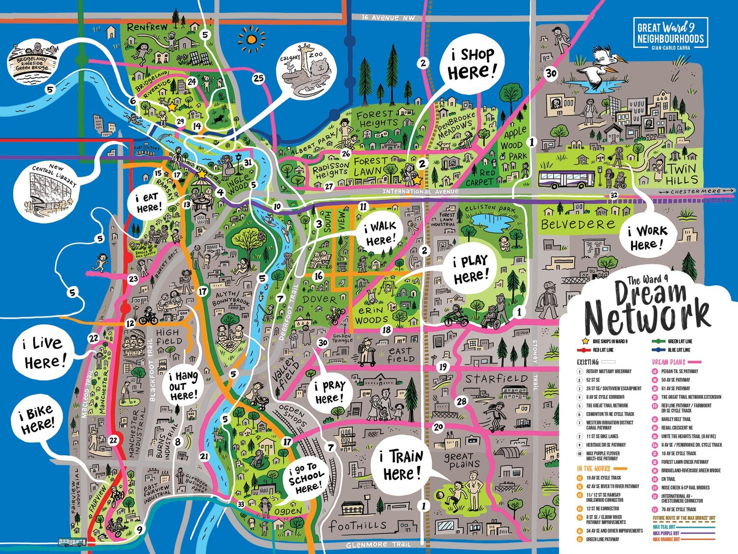
pathway map
 
Definitely would be nice to have more east west infrastructure, there’s very little of it in Calgary, and it’s even worse for industrial areas. I think it could be done easily enough if the political will there.
Won't the Green Line provide better East-west connectivity through the SE industrial area? It will have a bridge in the vicinity of Ogden Road that I assume will include a pedestrian/bike crossing.

Also, the pathway along 39th provides not bad access up to about Ogden Road. With the Green Line station at Highfield and a new river crossing, that should get much better.

In a dream world, everything between Ogden Road and the Bow would be redeveloped. Three large parcels (CPKC Alyth, Canada Malting and ADM) comprise much of that area and most of the other parcels are low value light industrial. I suspect remediation costs would be enormous, but imagine the potential of riverfront parks with stair stepped mixed use rising from it and Ogden Road transformed into a main street.
 
It’s probably an issue with demand with building dedicated bike lanes in the industrial areas. Although I can’t see why the sidewalks can’t be widened and made a shared ROW as a standard in new industrial areas

Industrial areas are such low density, it's really hard to service them effectively. A lot of industrial areas are in the ~3000 jobs per sq km range; as a comparison, if you built 1.6 km of cycle facilities connecting Barlow and 52nd St SE, there would be roughly 5000 employees of the buildings vaguely near the path, within one block (using one large industrial block as the measure).
1696439783533.png


One block around the 3rd Ave cycle track, for instance the block across from Livingston Place, would service 10,000 workers (and the 300 or so apartments in the International hotel conversion), and that's using the much smaller downtown blocks and not picking the densest block of the track. And with 1/10 the cycle track amount; these figures are roughly the same scale. That's a 20x return on investment (assuming the same cost per metre of cycle facility, which is probably not true.)

1696443159501.png


I think that the best approach for industrial areas is:
1). New areas should get pathways built as standard. The cost of a sidewalk on one side and a pathway on the other side of the street is pocket change in the cost of building a new road in an industrial area, and it should always be done. I was in some new industrial land in the NE this summer, and this is being done there; good job! This is looking at the intersection of Barlow and Country Hills NE from the northwest; the pathways (ie nine foot wide pieces of asphalt) are highlighted in yellow. There's no point in making future problems for ourselves. But note also that this is still an industrial area, so there are a lot of driveways, big sweeping corners and so on -- it's still not as cycle friendly as other areas.
1696439320007.png

2). Sidewalk refit / retrofit programs, to the degree they happen, should upgrade to a multiuse path on at least one side of the street whenever possible. If we're adding in sidewalks, may as well add in bike connectivity.
3). Consider adding key pathways in industrial areas where it makes the most sense. These are areas that have:
- higher densities of jobs (for highest benefit)
- higher numbers of residents within 2-5 km (reasonable cycling range)
- non-industrial uses, such as commercial areas (so that shoppers can also cycle)
- connectivity to the main city-wide pathway network (to enable longer-distance cycling for those who might do it).
The two main areas that fit this are the Manchester area / central industrial area west of Blackfoot, and the Franklin/Meridian/Sunridge area in the northeast industrial area east of Barlow. There is a semi-reasonable pathway through the NE industrial area that connects from Rundle LRT to the Nose Creek pathway running just north of 16th Ave and then curving through Vista Heights; the 42nd Ave S upgrades connect to the Elbow pathway. Also notable is that both areas have or are near to significant regional facilities that could also be destinations for cyclists; Chinook Centre and Sunridge/Lougheed Hospital.

I've posted before this crayon design for the Manchester area, where existing/new pathways are in green/cyan, existing/new cycle tracks are in yellow/orange and existing/new sidewalk/path retrofits are in magenta/pink:
1696440973257.png

A back-of-the-envelope costing was $10M for the new facilities in residential areas and $22M in the industrial areas; about the same linear amount, but sidewalk/path construction is much more expensive per meter than cycle tracks, since there's more actual construction work involved. There's roughly 25000 jobs in the industrial area here (not including Chinook), or 2.5x the number of jobs adjacent to the one block of downtown cycle track I showed above. I think this also highlights the importance of not just building in industrial areas, but also the adjacent communities.
 

Attachments

  • 1696439858235.png
    1696439858235.png
    658.8 KB · Views: 61
Last edited:
I think we'd get better ROI by focusing on the low hanging fruit that is filling in the many gaps in the bike network that exist in residential and office/retail areas before moving on to industrial areas.

For example the bike paths they added to 42 Ave are nice but that's a case where that $4.5 million could have served a greater benefit to more users had it been allocated elsewhere.
I think you're 100% right; I was talking about the best thing to do given building cycling in industrial areas, but industrial areas are absolutely low ROI, for so many reasons.


I can see the thinking behind 42 Ave path - when you include the 11 St SE part, it connects the Elbow River path at Stanley Park to the Bow River path near Heritage Drive. The value isn't just what it goes past, but the end-points it connects.
I don't think this is a very strong argument. For one, of the 7 km between Elbow and Bow, 1.2 km of this is in mixed traffic without even a painted lane; on 11th St through the Glenmore underpass and south to Heritage, and then a section through Deerfoot Meadows mixed in traffic. For another, most cycle commutes aren't super long -- the average cycle commute in Calgary per the Census is 23.2 minutes, and 2/3 of the commutes are under 30 mins (90% are under 45 mins). At a typical effective commute speed of ~13 km/h*, that's 5 and 6.5 km respectively (45 mins is about 10 km). From the intersection of 42nd and 11th along 11th to the closest single house is about 6 km (the 11th St connects to the Bow River pathway halfway between the Glenmore bridge to Ogden and the Eric Harvie bridge to Riverbend), so I suspect very few people are taking advantage of the connection to commute; if people are cycling for leisure and want to go through industrial areas, more power to them, I guess.

* yes, people cycle faster, especially you (or the speed demon terrifying you as they whiz past), but the actual commute time is not done at the highest speed; if someone has a car commute that takes them 15 minutes, it's probably not 25 km even though you can do 100+ on Deerfoot or Stoney, and it's probably not even 12 km even though that's the speed limit on most roads. When (hypothetical example) I leave home at 8:00 to bike somewhere, once I've gone to the bike room, unlocked my bike, mounted my bag and bottle, started my smart watch, it's 8:02 or 8:03. When I arrive at my office at 8:26, by the time I get in the bike cage, lock my bike, get my bag, and go up to the office, it's 8:30, so a 30 minute commute has 23 minutes of actual ride time, some of which is spent waiting for lights, slowing to turn corners, etc.
 

Back
Top