News   GLOBAL  |  Apr 02, 2020
 8.9K     0 
News   GLOBAL  |  Apr 01, 2020
 40K     0 
News   GLOBAL  |  Apr 01, 2020
 5.1K     0 

But then it goes back to whether it is the best served route. The problem I have with the SRT and the LRT option from day one is the land use surrounding it up until Scarborough City Centre. Lots of back-facing, low density residential, industrial and commercial, save for the patch of medium-high residential at Lawrence East station.

The opportunity with the subway extension is to put it along a street and promote some intensification that would help generate ridership for infill stations. Actually create a vibrant mixed-use street.

This has been studied before. Using the SRT corridor would serve more people and developer more developable land by a wide margin

The part of the SRT corridor, between Ellesmere and Scarborough Town Centre, will have 50,000 people (including jobs) within walking distance of the line and have 162 hectares of developable land. The remainder of the SRT corridor (between Kennedy and Ellesmere) wasn't studied, but it would put even more people, jobs and developable land within walking distance.

The original 3 stop Scarborough Subway proposal had only 32,000 people wishing walking distance and 82 hectares of developable land. Both of these numbers would be even smaller now that two stops have been cut.
 
Last edited:
...
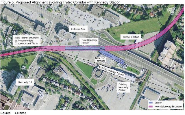
Pictured below is a rough design of Kennedy Station component of this proposal, with a "loop-back" to get on the SRT corridor. The loop-back shown below are of 100m and 150m radii, requiring roughly 500 m and 700 m of tunnelling respectively. A 100 metre radius is tighter than any turn in the system, should be able to be achieved if we switch Line 2 from 25 metre cars, to 17 metre cars. This is a reasonable proposal, since the Line 2 cars are up for retirement soon. A 150 metre curve radius, the same as the curve east of Union Station, can be achieved with our current 25 metre cars, but speed restrictions would need to be in place through the curve.

The TTC previously came back with much larger curves, requiring several kilometres of tunnelling, but that was because they didn't want speed restrictions. Council has directed them to reexamine the options, and I expect them to come back with options include tighter radii, with less tunnelling, but with speed restrictions in place.
edVpizU.png

Dumb question, but why can't they built a completely new Kennedy station, away from the old one (minimizing disruption) then decommission the old station.

Surely building a new station with the old alignment wouldn't compare to the cost of the tunnel option.

i.e. what I've drawn in red, below - just follow the old [hydro?] right-of-way to the SRT alignment.

The new Kennedy station could even be elevated above Eginton Ave with station houses on each side of Eglinton
- access to the Crosstown LRT could be right on Eglinton.

5CcpKVM.png


LjeKPNc.jpg


https://www.google.ca/maps/place/Ke...2!3m1!1s0x89d4ce3cc58aa3b5:0x4a9e92212406e482
 
Last edited:
Dumb question, but why can't they built a completely new Kennedy station, away from the old one (minimizing disruption) then decommission the old station.

Surely building a new station with the old alignment wouldn't compare to the cost of the tunnel option.

i.e. what I've drawn in red, below - just follow the old [hydro?] right-of-way to the SRT alignment.

The new Kennedy station could even be elevated above Eginton Ave with station houses on each side of Eglinton
- access to the Crosstown LRT could be right on Eglinton.
2

What you're proposing isn't new. Steve Munro had this posted on his website from a past TTC study done years ago:

kennedystation2.jpg
 
What you're proposing isn't new. Steve Munro had this posted on his website from a past TTC study done years ago:

kennedystation2.jpg

When I moved to Scarborough 6-7 years ago I was so confused I could never see the station from the street so one day soon after I played "where's Waldo ?" and went on a hunt to find it & when I finally located the tucked away station I was just as baffled at the unwelcoming design. Since Kennedy/Eglinton is going to become a major transit hub it would also make sense to have the station in a more optimal location closer to the intersection.

Great idea for many reasons
 
Last edited:
I wonder if there is consideration of turning the existing mccowan yard into additional storage space for the excited subway line, much like they are curently doing with Vincent yard in the west end.
 
Good point & certainly in terms of the time it will take to design & build the extension, the land it question could easily be acquired.

Semi-agree on the Lawrence topic. Possible stops were still to be reviewed had the McCowan alignment moved forward & Scarborough Councillors would certainly wait for an opportune time to put it back on the table. And we all know the latest proposal is just that & far from concrete. What I do agree with is that RT alignment could alleviate the majority of the issues that would certainly cause further drawn out, nagging debates from either side down the road.
They won't have much of a wait.

http://www.thestar.com/news/queensp...n-suddenly-gives-up-his-scarborough-seat.html

This Scarborough-Rouge riding includes both McCowan/Sheppard and Malvern, so both alignments are on the table. We know what happens at by-election time.
 
Normally, elevation is the solution to most transit problems, but probably not here.

First of all, the subway is probably about 8 to 10m below grade at the current Kennedy station. Eglinton is probably a couple of metres above grade as it prepared to cross over the railway tracks. A subway over Eglinton would have to be about 7m above Eglinton (5m clearance, plus 2m for beams, deck, etc.).

Thus, the tracks would have to gain about 15m to 20m of elevation to cross Eglinton. The station would have a level grade, so this elevation change must be completed south of Eglinton. At 2% grade, and adding in vertical curves, the track would have to be removed going back close to a km to allow for the proper slow grade raise.

LRT and SkyTrain can handle much greater grades (and tighter curves). That is why it was possible for the ECLRT to be elevated west of Kennedy and over Kennedy, and then dive underground (barely) for Kennedy Station and then curve under the Eglinton/GO bridge and continue north at-grade.
 
If only there was some kind of lighter railed transit that could navigate the tight curves of this area above ground and get to STC.

Oh well, one can only dream.

Ah yes, if only the main transit backbone of the City wasn't built with Heavy Rail Subways. Keep dreaming.
 
They won't have much of a wait.

http://www.thestar.com/news/queensp...n-suddenly-gives-up-his-scarborough-seat.html

This Scarborough-Rouge riding includes both McCowan/Sheppard and Malvern, so both alignments are on the table. We know what happens at by-election time.


http://www.cbc.ca/news/canada/toronto/doug-ford-ontario-1.3521970

You stand correct.

Should be interesting because a good portion of this riding benefits from the LRT plan. It's West of McCowan that has little use for the transfer to the stub
 
Normally, elevation is the solution to most transit problems, but probably not here.

First of all, the subway is probably about 8 to 10m below grade at the current Kennedy station. Eglinton is probably a couple of metres above grade as it prepared to cross over the railway tracks. A subway over Eglinton would have to be about 7m above Eglinton (5m clearance, plus 2m for beams, deck, etc.).

Thus, the tracks would have to gain about 15m to 20m of elevation to cross Eglinton. The station would have a level grade, so this elevation change must be completed south of Eglinton. At 2% grade, and adding in vertical curves, the track would have to be removed going back close to a km to allow for the proper slow grade raise.

LRT and SkyTrain can handle much greater grades (and tighter curves). That is why it was possible for the ECLRT to be elevated west of Kennedy and over Kennedy, and then dive underground (barely) for Kennedy Station and then curve under the Eglinton/GO bridge and continue north at-grade.

Thanks.

I was wondering about that, but the elevation looks pretty level at the exit from the bus loop (see bus in streetview pic below):

2x196Fl.jpg

https://www.google.ca/maps/@43.7324...4!1sJTlDLcoe71cx3UFfy05VQQ!2e0!7i13312!8i6656

and there looks to a wide RoW to the west for a new adjacent portal structure, then elevated over Kennedy Road and elevated over Eglinton Ave East.
I wonder how deep the tunnel is buried on the RoW west of Kennedy Road?
The station could even be located behind that short office building with entrances on Kennedy and on Eglinton.

PQ5xUQ1.jpg

https://www.google.ca/maps/@43.6946937,-79.2697075,3691a,20y,44.27t/data=!3m1!1e3
 
Last edited:

Back
Top