News   GLOBAL  |  Apr 02, 2020
 8.9K     0 
News   GLOBAL  |  Apr 01, 2020
 40K     0 
News   GLOBAL  |  Apr 01, 2020
 5.1K     0 

What do you believe should be done on the Eglinton Corridor?

  • Do Nothing

    Votes: 5 1.3%
  • Build the Eglinton Crosstown LRT as per Transit City

    Votes: 140 36.9%
  • Revive the Eglinton Subway

    Votes: 226 59.6%
  • Other (Explain in post)

    Votes: 8 2.1%

  • Total voters
    379
I'm not sure what you're trying to say here. By "above ground" do you mean elevated? Above ground can mean a lot of things.

I meant elevated.

Anyway, another question to throw out there. We know that the city already has a decent idea of where stops are going. Given the stop spacing is it practical to elevate the line? Would that not add significant costs to stations? ...which of course, would mean much higher overall costs if the number of stations don't come down.
 
Elevated stations are the real monstrosities.

Not all elevated stations have the same impact. Elevated Stations with mezzanines (i.e. stations above the middle of the roadway) have a much bigger impact (taller to fit mezzanine underneath and spans the roadway in shadow) than elevated stations at the side of the roadway (no mezzanine, shorter, smaller scale).

I think this is more or less specific to the ICTS itself, not elevated guide ways in general. My understanding was that the snow interferes with the linear motors along the trackbed. With traditional traction motors, like in the streetcars & subway, even if snowfall slows traffic down they can at least still move.

There's only 1 cm clearance between the linear motor and the "reaction plate" between the rails. SkyTrain runs trains 24/7 during snow storms to clear snow. Since SRT is not fully automated, it doesn't have that luxury. A fully automated Eglinton Crosstown Line would be able to run trains to clear snow.
 
Last edited:
As if elevated stretches of transit lines are any uglier than road or rail overpasses, plenty of which already exist along Eglinton...
 
One plus of elevated railways is that they can offer some pretty sweat views. Obviously not a reason to build one, but they are more pleasant to ride than subways imo.
 
Yeah, it'd be nice for visitors when boarding the trains at the airport to have a panaromic view of the city as they're riding inwards.
 
Yeah, it'd be nice for visitors when boarding the trains at the airport to have a panaromic view of the city as they're riding inwards.

but won't it cut off both sides of eglinton, i mean ppl say that the gardiner cuts off the city from the waterfront, I just don''t see how this will be any different...I don't know I've never been a fan of elevated ROWs unless they're in a theme park(disneyland) or dubai... it will make the streetscape much darker and it won't feel as clena or natural as a on road ROW imo, I think an on road ROW can look very natural with vegetation, and the right flooring, I honestly think that as long as the LRT is in its on ROW in the middle of the road, and POP I feel very confident that the level intersections will not really affect the overal efficiency of the line as a whole, i've been to Vancouver and seen the sky train and while it does look nice with many of the buildings near the waterfront and in open spaces further into its suburbs, I just don't think an elevated ROW would quite fit with Eglinton's image.
 
When it comes to "sweet views", take a subway to Coney Island, and delight in how it becomes an elevated floating above nondescript-and-all-the-better-for-it Brooklyn sprawl: the local equivalent to, say, Eglinton/Dufferin/Caledonia/Keele-type zones. But it sure doesn't mean they'd do it the same way afresh today...
 
I think this is more or less specific to the ICTS itself, not elevated guide ways in general. My understanding was that the snow interferes with the linear motors along the trackbed. With traditional traction motors, like in the streetcars & subway, even if snowfall slows traffic down they can at least still move.
Yes I know, that's what I was getting at. A traditional LRT could be elevated without the snow problems, and with similar capacity. Of course, it doesn't have to be grade separated to operate as true rapid transit. Calgary's northeast line (along 36 St NE) is a good comparison to Eglinton or Sheppard. So is the new LRT along 111 St in Edmonton. Both run down the middle of the street.
 
Yes I know, that's what I was getting at. A traditional LRT could be elevated without the snow problems, and with similar capacity. Of course, it doesn't have to be grade separated to operate as true rapid transit. Calgary's northeast line (along 36 St NE) is a good comparison to Eglinton or Sheppard. So is the new LRT along 111 St in Edmonton. Both run down the middle of the street.
Do we know what the SRT "upgrades" are supposed to be yet?

Any idea what the ridership numbers are for Calgary and Edmonton on those lines? I know they can't really be directly compared to Toronto as the cities are vastly different than Toronto, but nonetheless it would be interesting to know the numbers (in context).
 
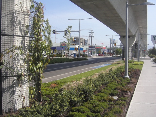
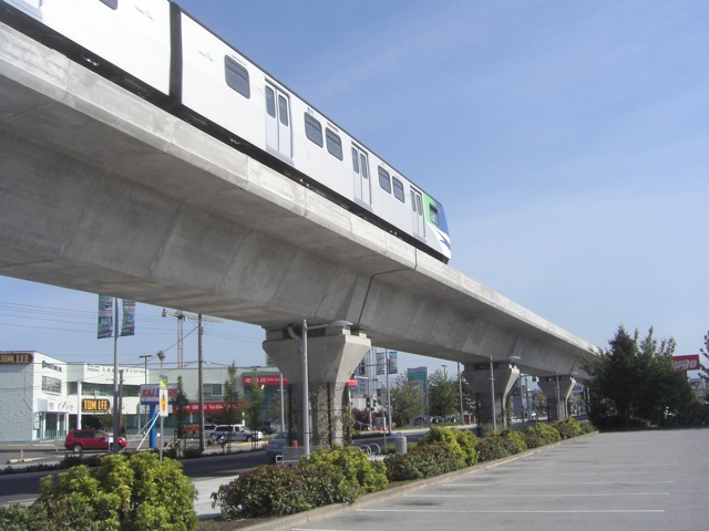
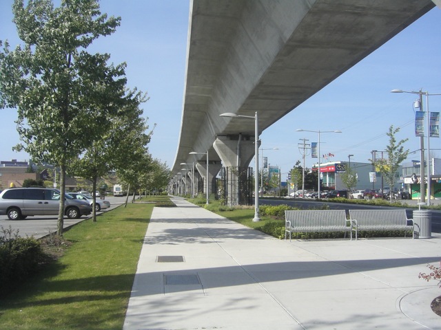
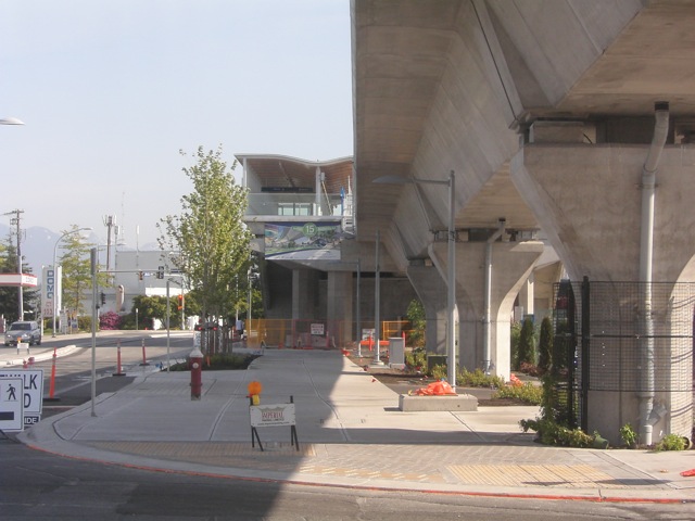
Richmond is doing a good job of beautifying the areas under the guideway on No. 3 Road (its downtown) - Burnaby didn't do anything much under the M-Line guideway. The one added benefit of ALRT over LRT is that it is third rail - so if it is elevated, there are no caternary wires and poles adding to the perceived height of the guideway structure.

An in-median LRT would have more "community dividing" effects than an elevated guideway. Typically, at grade LRT tracks force the closure of intersections with minor side streets (forcing "right-in, right out" movements) and prohibiting pedestrian crosswalks across the street except at major intersections.

Pics of some of the already planted areas by Tafryn:
http://canadalinephotos.blogspot.com/

KICX5976.jpg


KICX5977.jpg


KICX5984.jpg


KICX5952.jpg
 
Last edited:
Richmond is doing a good job of beautifying the areas under the guideway on No. 3 Road (its downtown) - Burnaby didn't do anything much under the M-Line guideway.

Pics of some of the already planted areas by Tafryn:

KICX5976.jpg

I mentioned that earlier. I walked along the line and it wasn't dark or depressing as some people have claimed it would be. The sun gets through, and the landscaping makes up for the concrete overhead. It does offer some protection when it rains so it ends up being a plus for pedestrians. The division that people claims elevated rail would create does not exist. The entire street seems to be designed around the line, meaning it fits right in. Im sure we could do the same with Eglinton.
 
Richmond is doing a good job of beautifying the areas under the guideway on No. 3 Road (its downtown) - Burnaby didn't do anything much under the M-Line guideway. An in-median LRT would have more "community dividing" effects than an elevated guideway. Typically, at grade LRT tracks force the closure of intersections with minor side streets (forcing "right-in, right out" movements) and prohibiting pedestrian crosswalks across the street except at major intersections.

Pics of some of the already planted areas by Tafryn:

KICX5976.jpg


KICX5984.jpg


KICX5952.jpg

is there anyway to submit those to Metrolinx. It might influence their choice on Eglinton
 

Back
Top