News   GLOBAL  |  Apr 02, 2020
 9.4K     0 
News   GLOBAL  |  Apr 01, 2020
 40K     0 
News   GLOBAL  |  Apr 01, 2020
 5.3K     0 

^its not about empirical numbers but about how many people actually commute. Durham has very high GO use due to its cheap housing and easy access to downtown via the Lakeshore line.. Lakeshore east probably has more use per capita served by it then Lakeshore west. Highway access is difficult to durham (though not so much once the 407 opens), so many commute by train.
 
What is the value in balancing it symetrically? I would imagine that the population of people/potential riders between Aldershot and Stoney Creek is significantly higher than from Oshawa to Bowmanville?

It would in essence provide express services to people on the outer ends of both Lakeshores, not just Lakeshore West. For what it's worth, we're probably looking at a similar service pattern for the Kitchener line, with RER stopping at Bramalea (though eventually stopping at Mt. Pleasant).
 
It would in essence provide express services to people on the outer ends of both Lakeshores, not just Lakeshore West. For what it's worth, we're probably looking at a similar service pattern for the Kitchener line, with RER stopping at Bramalea (though eventually stopping at Mt. Pleasant).
I get the concept of service levels changing along lines at some point.......just not sure what the value of the "balancing" is.....each line should be viewed separately based on their populations/ridership and the point of service demarcation determined for each....but some sort of artificial "balancing" based on, it appears, distance seemed strange to me.
 
I get the concept of service levels changing along lines at some point.......just not sure what the value of the "balancing" is.....each line should be viewed separately based on their populations/ridership and the point of service demarcation determined for each....but some sort of artificial "balancing" based on, it appears, distance seemed strange to me.

I get what you're saying. From an operational perspective though, I suppose it would be easier/more efficient to run services as thru services at Union, instead of terminating them there. Especially when in the near future GO is going to be operating more than one kind of rolling stock, being able to "pair" services with the same rolling stock up to thru at Union would likely be seen as an advantage.
 
I get what you're saying. From an operational perspective though, I suppose it would be easier/more efficient to run services as thru services at Union, instead of terminating them there. Especially when in the near future GO is going to be operating more than one kind of rolling stock, being able to "pair" services with the same rolling stock up to thru at Union would likely be seen as an advantage.
I understand that too....again though, not clear to me why the end points have to be equally far from Union....the populations west of Aldershot are clearly larger than the populations east of Oshawa (I think).
 
I understand that too....again though, not clear to me why the end points have to be equally far from Union....the populations west of Aldershot are clearly larger than the populations east of Oshawa (I think).

Not necessarily equidistant from Union, just that both ends have stations that "overhang" beyond the end of the RER service area. Granted, Clarington isn't Hamilton, but I think there would be enough ridership coming from Bowmanville, Courtice, Oshawa Centre, and Thornton (and Oshawa + Whitby stations) to justify an hourly or 30 min bi-level express service to Union, probably with 6 or 8 car trains. This would pair nicely with the plan for Lakeshore West into Hamilton Centre. West Harbour would probably end up on the Niagara line, which would be separate from LSW.
 
Granted, Clarington isn't Hamilton, but I think there would be enough ridership coming from Bowmanville, Courtice, Oshawa Centre, and Thornton (and Oshawa + Whitby stations) to justify an hourly or 30 min bi-level express service to Union, probably with 6 or 8 car trains. This would pair nicely with the plan for Lakeshore West into Hamilton Centre.
With the current funded projects, hourly to Hamilton Hunter by ~2024 is only possible without difficult solutions. Beyond that (half hourly) is a little bit of a wildcard involving grade separation and probable electrification.

I'm even unsure hourly AD2W will go to Hunter by then, having witnessed the Hamilton Rail Junction expansion well under way, but absolutely nothing occuring on the CP side at this time. I could be proven wrong, though.

The future incremental beyond RER 10-year plan (future study) 30-minute (or better) all day fate of AD2W to West Harbour versus Hunter, is still undefined as of 2016.

http://www.metrolinx.com/en/regionalplanning/projectevaluation/benefitscases/GO_RER_Initial_Business_Case_Appendix_A-J_EN.pdf
"All-day two trains per hour EMUBL4/EMUBL8 or E1BL8 to Hamilton West Harbour, or Hamilton Hunter with express Burlington-Union requires electrification of Aldershot to Hamilton, and potential addition of track and grade separation (or alternate track solutions) at Hamilton Junction. "

This is a new 2016 document -- this is the Appendix A for the recently released huge nearly-200-page GO RER Business Case document -- which actually mentions Hamilton electrification as an area of future study (My speculation is this will happen only after the 10-year plan. Late 2020s, early 2030s, perhaps? Is it too daring to hope this can be accelerated!?).
 
Last edited:
Some of us have digested the brand new GO RER Business Case document extensively already, but few people talk about the equally huge Appendix A. I finally researched the document today. Here's some new heads-up.

It looks like Lakeshore East/West is NOT initially going to use EMUs, but will be using electric-locomotive-driven BiLevels, as I originally predicted. EMUs will go onto Bramalea-MtJoy with most short-turning at Unionville.

Here's the electric locomotive/EMU plan:

upload_2016-4-13_13-26-20.png


upload_2016-4-13_13-26-51.png

upload_2016-4-13_13-32-5.png

upload_2016-4-13_13-35-0.png

upload_2016-4-13_13-35-4.png

upload_2016-4-13_13-38-26.png
 

Attachments

  • upload_2016-4-13_13-26-20.png
    upload_2016-4-13_13-26-20.png
    52.7 KB · Views: 893
  • upload_2016-4-13_13-26-51.png
    upload_2016-4-13_13-26-51.png
    119.9 KB · Views: 906
  • upload_2016-4-13_13-32-5.png
    upload_2016-4-13_13-32-5.png
    139.3 KB · Views: 907
  • upload_2016-4-13_13-35-0.png
    upload_2016-4-13_13-35-0.png
    172.1 KB · Views: 873
  • upload_2016-4-13_13-35-4.png
    upload_2016-4-13_13-35-4.png
    172.1 KB · Views: 923
  • upload_2016-4-13_13-38-26.png
    upload_2016-4-13_13-38-26.png
    158.2 KB · Views: 881
Last edited:
This is really exciting and interesting. I'm curious about details on where the crossing will be (as recommended in EA or something else) and what future will be for current Oshawa GO will be.

I believe there's been some speculation on here the GO train extension to Bowmanville could use the CN tracks (or parallel) to them instead of CP but I think the consesus is that they would stick with the original plan and associated EA.
 
This is really exciting and interesting. I'm curious about details on where the crossing will be (as recommended in EA or something else) and what future will be for current Oshawa GO will be.
The EA has been been on the GO website for 5 years now. See http://www.gotransit.com/public/en/improve/environmentalassessments.aspx - in particular http://www.gotransit.com/public/en/improve/ea_oshawabowmanville.aspx

Though it can be briefly summarized in the following figure:

upload_2016-4-13_14-27-35.png
 

Attachments

  • upload_2016-4-13_14-27-35.png
    upload_2016-4-13_14-27-35.png
    426.4 KB · Views: 858
I believe there's been some speculation on here the GO train extension to Bowmanville could use the CN tracks (or parallel) to them instead of CP but I think the consesus is that they would stick with the original plan and associated EA.

You mean sticking south of the 401 on CN tracks, or the connection illustrated east of Simcoe Street in nfitz's figure?

If the former, the municipalities specifically requested that GO use CP's tracks, so stations could be closer to their city centres. If the latter, it's gone.
 
The EA has been been on the GO website for 5 years now.

Interesting part of that map is that the Oshawa harbour spur has since been extended and the north-south former CN spur into downtown Oshawa that was removed years ago.
 
You mean sticking south of the 401 on CN tracks, or the connection illustrated east of Simcoe Street in nfitz's figure?

I did mean sticking to the CN tracks all the way to Bowmanville. Like I said, I think it was just speculation and you're right, it makes more sense to take the line directly into the urban centres.
 
Last edited:
Barrie Line double tracking update, April 10 2016.

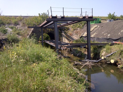
It looks like work been focused on the embankment south of Langstaff Road, which includes replacing the culvert over the West Don river with a viaduct. The rest of the line looks the same as it did when I visited four months ago.

Looking south from Langstaff:
25832423853_1b52c0cbf5_b.jpg


The curves seem rather abrupt, hopefully the final alignment will still maintain the current 75 mph (120 km/h) speed limit.
26435246505_b777b7038f_b.jpg


Overview of embankment widening:
26409561946_bd04479ddf_b.jpg


New bridge over the West Don River. There are 3 pillars, which suggests it will be 3 tracks wide.
26409301496_bb1c9a458d_b.jpg


25832436853_b0cee197d8_b.jpg


For comparison, here was the same view in September 2015:

26409509306_0fd8ef9488.jpg
 
That curve has a 45-25 speed limit sign (45 psgr, 25 freight) for the existing track. Could be for construction only.

- Paul
 

Back
Top