News   GLOBAL  |  Apr 02, 2020
 8.4K     0 
News   GLOBAL  |  Apr 01, 2020
 39K     0 
News   GLOBAL  |  Apr 01, 2020
 4.7K     0 

I was looking at transit system maps for fun and I was trying to find an HSR system map, but have so far failed. The newest map I can find is from December 2019. Has Hamilton seriously stopped publishing actual system maps or is it buried impossibly far on their (incredibly bad) website somewhere?
Good news: the system map has returned to the website!
Bad news: it's still the December 2019 edition which has a few inaccuracies now.
 
Ladies and gentlemen… the HSR has provided the draft revised system network following the construction of the LRT. And it is fantastic. Many thanks to Joey Coleman for breaking the news.


CABEA561-DA39-4B99-957A-75917E4E6DE9.jpeg
5C008CFE-B5CC-4369-B721-3FDDB6CC87E7.jpeg
5D946BBD-73CC-4F02-A4F9-81A011A0D511.jpeg
011A6BC9-BD70-4BEA-B7BD-B8EDB7C11E10.jpeg

The full system map can be found here: https://pub-hamilton.escribemeeting...a=Agenda&lang=English&Item=25&Tab=attachments
 
Wow proposed changes that will actually bring the HSR into the 21st century? Heck it's even coloured??

Something different must've got into the water in Hamilton lately, because there's actually a lot to like, and these changes could take many routes of their current idiotic running arrangements. Although i do question some of the proposals (such as the 51 running all the way down to timbuktu far past the west end of Hamilton).
 
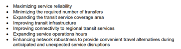
I figure I'll provide some more of the juiciest details from the document. Starting off, to catch everyone up to speed this was the planned transit expansion framework for the HSR (and by extension, Metrolinx):
1680136505678.png


This was always fairly ambiguous on what these lines actually meant, but it was effectively a "priority corridors" map and a basic idea of where rapid transit corridors would/might go.

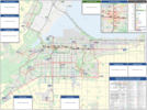
This has now been updated to the following:

1680136602098.png

Lots to go on about here. The current 5A, C, E, and 52's routes have been amalgamated in the map as the new 'T Line', acting as the western N/S route to travel the escarpment and reach Dundas.

At Mohawk, the T Line diverts from the old alignment and instead of going downtown, closes the N/S gap on the east Mountain at a new terminal. Here, the S Line and new (second) L Line meet.

The S Line now uses the Red Hill Valley Parkway to reach Parkdale Station, now interchanging with the new E Line and the modified T Line.

The B Line's bus extensions have been rearranged. With the new T Line going to Dundas, the B Line will instead go all the way to Winona rather than ending in Stoney Creek.

The old T and L Lines now compose the same, heavily interlined line going from Waterdown to downtown, Mohawk College, Limeridge, then back into the lower city via Kenilworth to Centre Mall at Barton (a great location for a future GO Station).
 

Attachments

  • 1680137564496.png
    1680137564496.png
    52.7 KB · Views: 123
The old T and L Lines now compose the same, heavily interlined line going from Waterdown to downtown, Mohawk College, Limeridge, then back into the lower city via Kenilworth to Centre Mall at Barton (a great location for a future GO Station).
I agree that the Centre Mall location would be great for a future GO station. Lots of room for mixed use infill, plenty of nearby employment lands, and some density towards the Ottawa st. Side of the mall. It all represents a middle point between West Harbour and Confederation GO, and would be the closest access to the industrial lands.
 
25+ years of raw sewage 👍
more like Hamilton has finally sealed the leaks and the sewage isn't fogging their brains any more ;)

I like the transit plan - I question why Barton is seemingly perennially forgotten in these transit plans though. It's the second busiest route for HSR and it still isn't deemed important enough for an express bus? I get that they expect some ridership to divert to the LRT, but still.

The Waterdown connection is also odd to me, an express bus running basically non-stop from downtown just to make a single stop in the middle of nowhere off of Highway 6. It at the very least needs to run down Dundas St through Waterdown to the east end of the town, ideally to the Dundas/407 Park and Ride in Burlington.

The other gaps which remain still are Binbrook and the Stoney Creek Waterfront. Binbrook doesn't even get on-demand service still, and Stoney Creek waterfront may work with on-demand service for now, but has 3-4,000 condo units in delivery right now which will change that profile.

The other big question of course is funding here. There are some very ambitious frequencies outlined here, most of which exceed existing services by a decent margin. What's the cost of implementing this network, exactly?

Other smaller things I like:
- Downtown Burlington bus is extended to Burlington GO
- Service finally extended to Winona
- continuous service through Ancaster from McMaster providing direct transit connections to the LRT
- rationalization of bus routes through downtown
- much better connections to West Harbour
 
Last edited:
Another thought relates to infrastructure.

There are 12 bus routes shown terminating at West Harbour GO, and what, 3 bus bays there currently?

Similarly, Parkdale LRT will likely need a terminal facility of some kind with 7 routes accessing it.

Also, it appears to abandon the downtown bus terminal. I'm fine with this, but some upgraded layover and passenger facilities will be needed along James St instead.

Heritage Green is also looking to become a major bus hub for the suburbs, and may want an improved dedicated facility over today.
 
The other big question of course is funding here. There are some very ambitious frequencies outlined here, most of which exceed existing services by a decent margin. What's the cost of implementing this network, exactly?
I wonder how much is feasible on Day 1 with the freed-up service hours taken over by the LRT. But yes, it's not clear how much service investment this map represents over the current baseline.
 
I wonder how much is feasible on Day 1 with the freed-up service hours taken over by the LRT. But yes, it's not clear how much service investment this map represents over the current baseline.
They go into the costs in the report in Appendix B. Short answer is that this proposal represents a massive 74% increase in annual cost.
Proposed.png
 
Assuming no increase in fare revenue, that would require about a 7% tax hike to pay for from the City. Probably 4-5% tax increase once you consider likely increased fare revenue from increased ridership.

Not going to happen in one budget year, but I could see it being phased in.

The problem is that Hamilton already has sky-high taxes and is already hiking them further to address their terrible infrastructure backlog. Not where if the population will tolerate 5 years of continuous 4% tax hikes to back this. And this isn't even including the increased costs of operating the LRT. Here's hoping I'm wrong.
Can this be offset by the future tax revenues from the AEGD? Stelco redevelopment? Etc.
 
Can this be offset by the future tax revenues from the AEGD? Stelco redevelopment? Etc.
If Hamilton could start attracting major commercial operators in a big way, yes. It's already made small inroads in increasing it's proportionate commercial tax-base, but has a lot further to go. That's it's real solution to fixing it's high income taxes. It needs a larger commercial tax-base.
 

Back
Top