News   GLOBAL  |  Apr 02, 2020
 8.9K     0 
News   GLOBAL  |  Apr 01, 2020
 40K     0 
News   GLOBAL  |  Apr 01, 2020
 5.1K     0 

Speaking of Bridges, does anyone know what happened to the Queen Street Subway bridge. I know there is construction going on the whole intersection but the bridge specifically that was the Queen Street subway is gone. I hope they are planning to put it back. The 1893 sign to the bridge now gets lots of sunlight but it sucks that the bridge is gone! Anyone?

Whoa! That's amazing! It's hard to believe that's where that daylight-blotting bridge has been for all these years! They're have to replace it for the sake of the trains, but... WOW!
 
Whoa! That's amazing! It's hard to believe that's where that daylight-blotting bridge has been for all these years! They're have to replace it for the sake of the trains, but... WOW!

indeed...

77341aef.jpg

b1db3e8f.jpg

f630e544.jpg

6ab7973c.jpg
 
February 25 addition... Remixed

4384913521_cb9b47cb03.jpg

Noice!

As breathtakingly large and commercial and somehow antispeptic this intersection has become it now fairly pulses with something. I can't help but be reminded of something in Tokyo. Not that I've been there; but I've seen pictures. :)
 
Oh, I think service vehicles can still access it and use it, and from what I've seen the times I've been there, routinely do... I meant a something still in use by the average guy trying to drive around town. We're fortunate they didn't bother to remove it, because other superseded bridges have gone by the boards... Lawrence at the East Don and old old Albion Road (Flindon Road) bridge spring to mind. Oh, and as previously mentioned by someone else, Old Dundas Street bridge on the Humber. I'd prefer they left things like that and simply closed them to vehicles but left them open to pedestrians, like they have with Old Cummer Avenue bridge and the newer old Albion Road bridge. :)

But yeah, old Bayview bridge is part of the campus and is routinely fenced off along the end of Lawrence. The last time I was there I actually had to climb down the bank and wade down the river to get to it; it was the easist way! But it looks like people up on the heights use it to exercise Fido so I wouldn't be surprised if by now someone has engineered another ad hoc access, bending a link in the fence here and there. :)

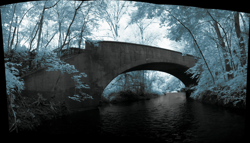
Taken from the Don, facing west (towards the new bridge); infrared four-photo pano assembled by AutoStitch and tinted in Photoshop in post-processing. Hoping this spring to take a shot matching one taken by Ted Chirnside in the 1950s from than bank just to my right in this view.

1572178950_973c22d0b0_b.jpg


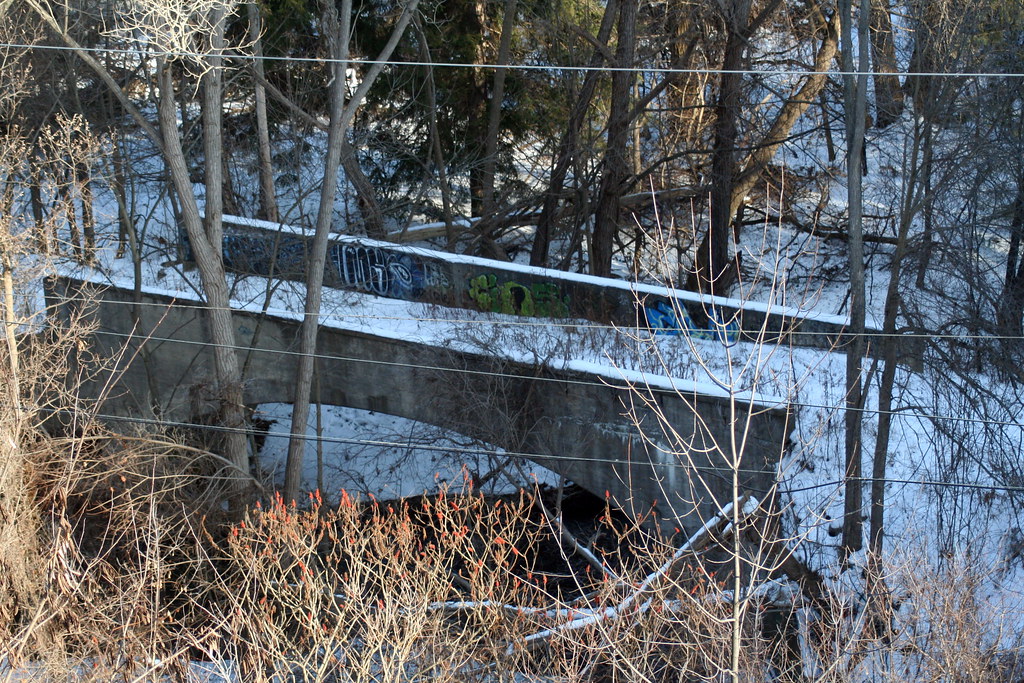
You can easily see this bridge, by the way, from east side of the current Bayview Avenue bridge north of Lawrence in the winter when the foliage doesn't disrupt the view:

2096944308_bfe630bab9_b.jpg

Where is this exactly?
 
Oh, I think service vehicles can still access it and use it, and from what I've seen the times I've been there, routinely do... I meant a something still in use by the average guy trying to drive around town.

Hard to tell--for all I know, after the high level crossing was built in 1929 it might have been pretty much usurped by the Glendon and/or Chedington estates--and as such, it might even be more "public" (from an accessibility, if not driveability, standpoint) now that it's Glendon College property...
 
Speaking of Bridges, does anyone know what happened to the Queen Street Subway bridge. I know there is construction going on the whole intersection but the bridge specifically that was the Queen Street subway is gone. I hope they are planning to put it back. The 1893 sign to the bridge now gets lots of sunlight but it sucks that the bridge is gone! Anyone?

Remember that that's only *one* of the Subway bridges, even if it seemed to have "priority" because of the datestone being next to it. In any event, I'd imagine they'd be planning some kind of reenstatement on behalf of the Railpath. And hopefully, some kind of appropriate restoration/preservation is planned for the datestone, acid rain etc victim that it is...
 
St. George and Bloor is one of the few intersections in Toronto in which the original buildings on three corners have been replaced by superior ones, while the best of the lot has been lovingly preserved. The three newer buildings represent fine examples of 1920's Art Deco, 1990's Deconstructivism and 2000's NeoModernism. Now if only the trees had been preserved, it would be a complete success story....

stgeorgeeast.jpg


stgeorgebloor-1.jpg


NE corner: the George Gooderham House (architect David Roberts Jr., built 1889-1902):

stgeorge2.jpg


SE corner, then:

stgeorge3SE.jpg


Now, Woodsworth College Residence (architectsAlliance 2004):

WoodsworthCollegeResidence-Universt.jpg


SW corner, then:

stgeorge5sw.jpg


Now, Bata Shoe Museum, (architects Moriyama & Teshima, 1995):

800px-Bata_Shoe_Museum.jpg


NW corner, then:

stgeorge4nw.jpg


Now, Medical Arts Building, (architects Marani, Lawson & Paisley, 1929):

MedicalArtsBuilding.jpg
 
Of course, the SE corner had the St George Graduate Residence and the SW corner had a gas station in the interrim...
 
Of course, the SE corner had the St George Graduate Residence and the SW corner had a gas station in the interrim...

Too true, and the Graduate Residence was an historically listed building, ironically by the same architects as the Medical Arts Building (Sonja Bata in fact fought its demolition by U of T). In this pic from 1936, the house on the SW corner is gone, and you can glimpse the top of the Graduate Residence on the right:

stgeorge1936.jpg
 
I wonder how well used the space in front of the Gooderham House is. It could make for a nice public space, and that brick and stone wall is starting to crumble.
 

Back
Top