|
|
|
You are using an out of date browser. It may not display this or other websites correctly.
You should upgrade or use an alternative browser.
You should upgrade or use an alternative browser.
- Thread starter Mustapha
- Start date
DSCToronto
Superstar
Yes, one could spend hours re-reading this fantastic thread. Thanks to Mustapha for starting it way back in 2008. (Interesting also to see the names of frequent posters like Urban Shocker who seem to have 'moved on' Even Mustapha - aka Jeff - himself seldom posts these days.)Wow - page 31 is an epic walk around pre-re-development Regent Park. Well done, @Mustapha ! It's a gift that keeps on giving
LPCI
Active Member
I lived on Glenview Ave on the west side of JRR, and halfway down the block towards Avenue Road on the north side was a huge pile of a house that occupied what would be three lots. It theoretically "faced" Glengrove Ave if one imagines that it was the only house when Glengrove was a driveway. The house is gone now. Sad. It had huge trees and one very ancient and noisy parrot.Hi seemsartless,
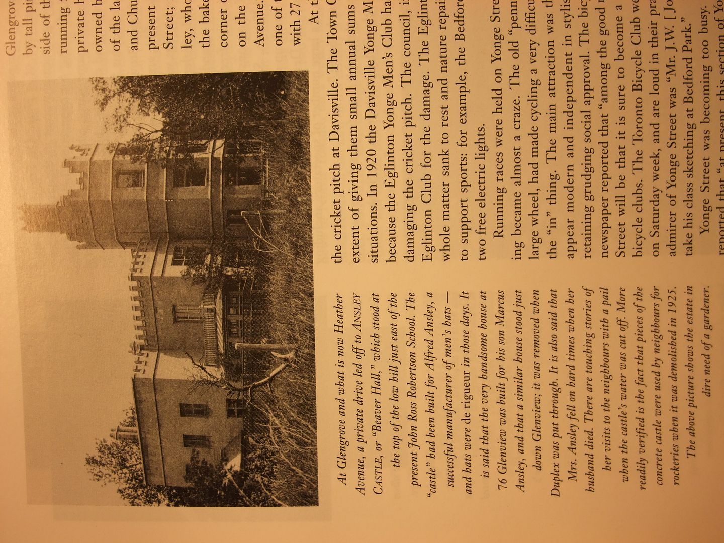
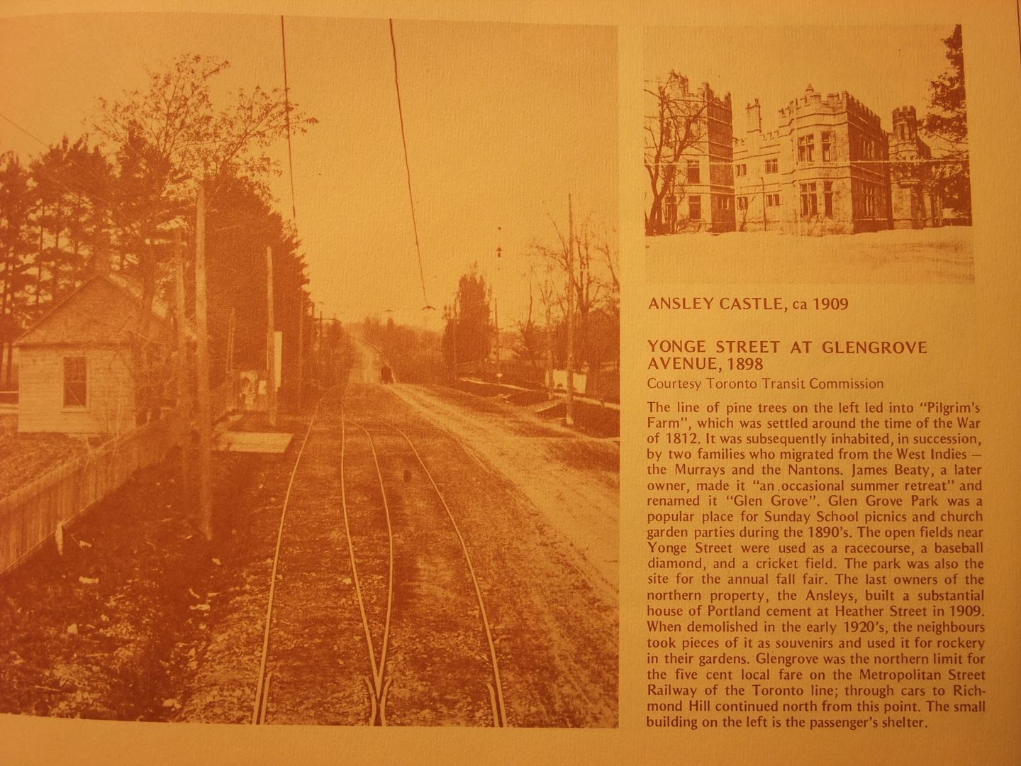
This isn't "Glen Castle", what it might be I can't be sure. There was an "Ansley Castle" at the corner of what is now Glengrove and Heather, on top of the low hill just east of the present day John Ross Robertson School.
If you can find a copy of Don Ritchie's "North Toronto" (Stoddart 1992) or a copy of "North Toronto in Pictures" (Toronto Public Library Local History Handbooks 1974). there are pictures of Ansley Castle. Time prevents making scans this evening.
From "North Toronto" page 88: "...the 'castle' had been built for Alfred Ansley, a successful manufacturer of hats..."
From "North Toronto in Pictures" page 19: "...the Ansleys built a substantial house of Portland cement at Heather street in 1909. When demolished in the early 1920s, the neighbours took pieces of it as souvenirs and used it for rockery in their gardens."
More on Glen Grove Park from "North Toronto in Pictures" page 19: "Pilgrims Farm [the name for the area before it became Glen Grove Park] was settled around the time of the War of 1812. James Beatty, a later owner, made it an 'occasional summer retreat' and renamed it 'Glen Grove'. Glen Grove Park was a popular place for Sunday School picnics and church garden parties in the 1890s.The open fields near Yonge street were used as a race course, a baseball diamond, an a cricket field."
I agree with your guess that your picture scene might be on the east side of Yonge - Blythwood Ravine. I could be wrong but I haven't been on Glengrove Avenue east in decades; it's a short no-exit street and I have no reason to be there but I don't think there is an extant house like that.
You have a nice website by the by.
LPCI
Active Member
That "castle" looks like the Hydro substation that's always been there. They used to disguise the substations to blend in.Here we go...
From the Ritchie book previously mentioned:

From the TPL book previously mentioned:

Goldie
Senior Member
Koolgreen
Active Member
I don't see them anymore, but as a kid, there used to be blue vent poles around town which looked like lamp poles and had turbines spinning up top....maybe ten feet high.... does anyone know what they were for???
Goldie
Senior Member
UserNameToronto
Active Member
Goldie
Senior Member
Sackville Street & Amelia Street, Cabbagetown. 1972 & 2016.
That's a fine restoration,
It looks like a residence now.
Are there still any stores on the street level?
Marmaly
New Member
Either sewer vents or ventilation for covered underground landfills (to vent methane).I don't see them anymore, but as a kid, there used to be blue vent poles around town which looked like lamp poles and had turbines spinning up top....maybe ten feet high.... does anyone know what they were for???
W. K. Lis
Superstar
Likely old city dumps.
Woodville Avenue dump (1914):


Lawrence & Avenue Road dump (1935):

St. Clair & Bathurst dump (1935):

Woodville Avenue dump (1914):


Lawrence & Avenue Road dump (1935):

St. Clair & Bathurst dump (1935):

UserNameToronto
Active Member
UserNameToronto
Active Member
That's a fine restoration,
It looks like a residence now.
Are there still any stores on the street level?
It was on the market a few months ago - it was owned by "Me to We / Free The Children" and used as office space from what I can tell. No store presence at street level.
UserNameToronto
Active Member
Red October
Senior Member
blogTO has a really good "Then & Now" piece on the Wheat Sheaf Tavern at King and Bathurst up right now. Opened in 1849, it has miraculously kept its same name for its entire existence. Also a cool fact - it only got its now-famous mansard roof in 1905.
http://www.blogto.com/eat_drink/2017/01/history-toronto-oldest-bar-wheat-sheaf/
1970's (good lord who ever thought that painting historic buildings white/grey looked good?):

1981:

2011:

https://www.google.ca/maps/place/Wh...2!3m1!1s0x882b34dfd58c092d:0x2ead559a7cd8f716
http://www.blogto.com/eat_drink/2017/01/history-toronto-oldest-bar-wheat-sheaf/
1970's (good lord who ever thought that painting historic buildings white/grey looked good?):

1981:

2011:

https://www.google.ca/maps/place/Wh...2!3m1!1s0x882b34dfd58c092d:0x2ead559a7cd8f716


