flonicky
Senior Member
Streetview 2009:

Oct 2022:

Oct 2022:
|
|
|
Streetview, 2009:
View attachment 436961
Nov 2022:
View attachment 436962
I usually like the 'after' views better, but this one is much worse.
Mt. Pleasant and Eglinton. Sorry.It would be helpful to identify where the pictures are taken.
I remember back about 1961 on the hill of Don Mills Rd, about opposite Northwoods Terrace going towards the shopping centre, at breakfast hour, there was a tremendous crash on our quiet street of Guytoi Court. A car flew off the top of the hill of Don Mills Rd, travelled through all the back yards and ended up in the back wall of 12(?) Guytoi Court (the pathway from Guytoi Court to Northwood Terrace was beside the house). Oooh, the excitement! Nobody was hurt I believe.
Very interesting pic, Jer1961! At first I was thinking that it had to be taken from John, not Peter, prior to the construction of Metro Hall, but after going through the following pics, I believe it is Peter Street.No "now" shot to go with this "then" shot... September 30, 1982, I took this on Peter Street (now Blue Jays Way) north of Wellington, south of Mercer, a little south of where Gretzky's was until recently. Looking east towards Roy Thomson Hall. No point in showing the "now" view as it is blocked by a Pizza place on Blue Jays Way, let alone a condo on the west side of John and Metro Hall on the East side... Brick building at left is rear of a building on Mercer
View attachment 440051
Very interesting pic, Jer1961! At first I was thinking that it had to be taken from John, not Peter, prior to the construction of Metro Hall, but after going through the following pics, I believe it is Peter Street.
The first stop was the 1924 Goad Atlas, given the presence of the train tracks that once led to the CP Express Building:
View attachment 440530
Given the train tracks, I was wondering if the brick buildings on the left were on Mercer or King, which led me to these pics:
1971:
View attachment 440531
This pic is from Peter Street and one can see the break in the warehouse facade where there once was a bridge over John Street:
View attachment 440540
These buildings were all part of the CP Express complex which included the main building on the SW corner of King & Simcoe (which architect Barton Myers tried to have saved (to no avail of course) and integrated into the "new Massey Hall" as it was called at the time):
1967:
View attachment 440538
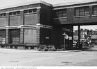
This view from Peter shows the site just prior to the demolition of the main building on King:
View attachment 440547
The Wellington buildings stayed a little longer after the main building was demolished:
Looking across John Street (1977):
View attachment 440539