News   GLOBAL  |  Apr 02, 2020
 8.4K     0 
News   GLOBAL  |  Apr 01, 2020
 39K     0 
News   GLOBAL  |  Apr 01, 2020
 4.7K     0 

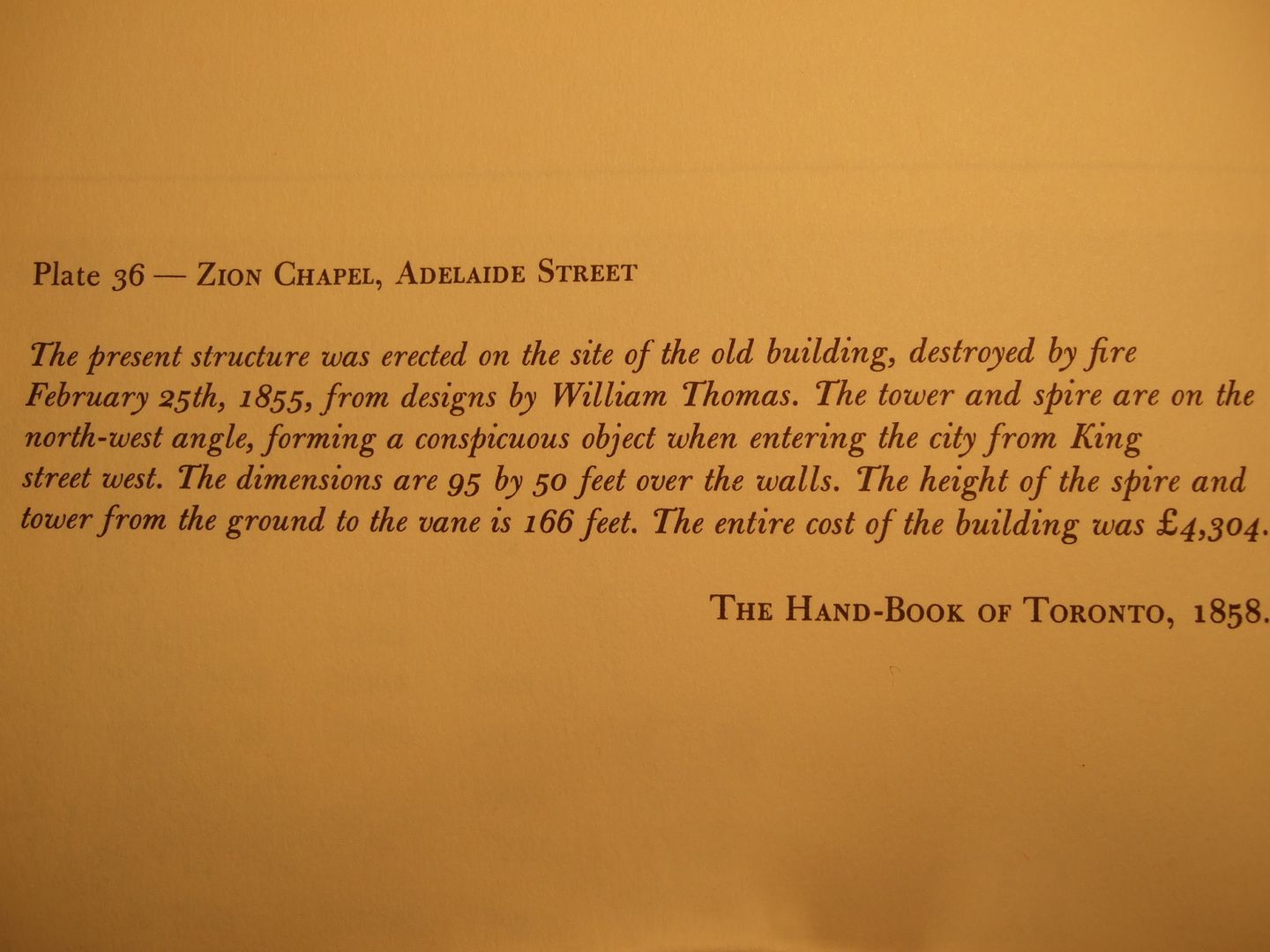
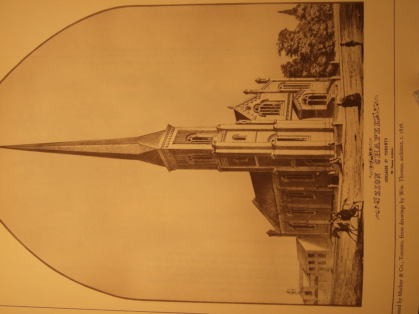
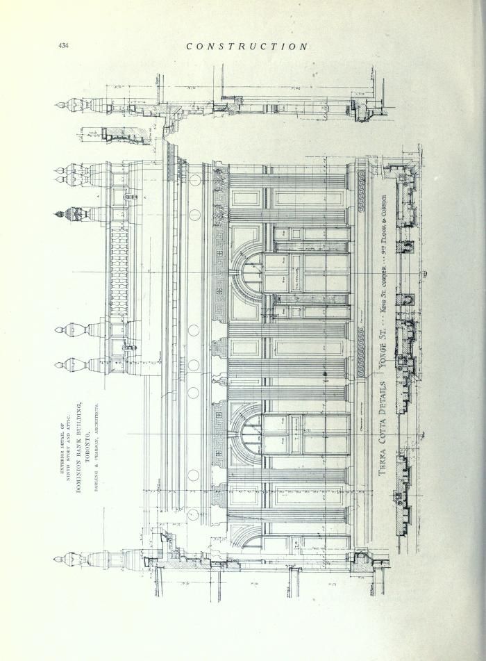
The Dominion Bank, as featured in the December 1914 issue of Construction (33 pages):

http://www.archive.org/stream/constructionjour07macduoft#page/424/mode/2up

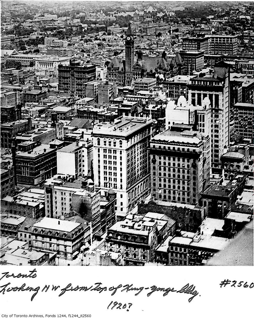
Nice find, wwwebster! Too bad about the loss of the roof-top balustrade:
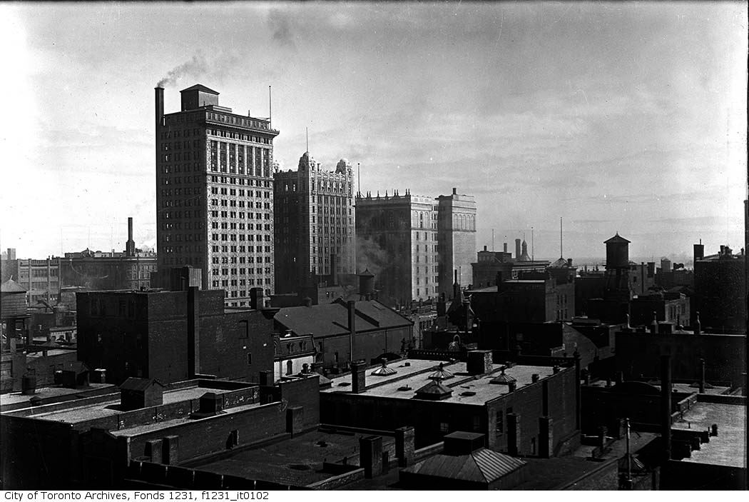
constructionjour07macduoft_0454.jpg


1919:

aerial1919.jpg


1920.jpg
 
Last edited:
Thanks for the great 1968 photo of the old City Limits terminal (in foreground) brings back memories. I remember some cold winter nights being dropped there by the old Yonge trolley to transfer to the old Bayview route that terminated there. It only ran every half hour and I had a knack for always just missing it. Inside was a great snack bar until they changed it over to a type of "automat" in 1963. Wasn't the same. They closed the doors the same day in 1974 when the subway was opened to Finch.
 
Mustapha, I edited your post a bit.

Thanks for the great 1968 photo of the old City Limits terminal (in foreground) brings back memories. I remember some cold winter nights being dropped there by the old Yonge trolley to transfer to the old Bayview route that terminated there. It only ran every half hour and I had a knack for always just missing it. Inside was a great snack bar until they changed it over to a type of "automat" in 1963. Wasn't the same. They closed the doors the same day in 1974 when the subway was opened to Finch.
 
end of streetcar line

Mustapha: "Fascinating. The terminal at Birch and Yonge, I wonder where it was, exactly..."

Is this not the terminal we're talking about (circled in 1968 photo) where the city streetcars terminated at the crest of Hoggs Hollow?
The 1932 photo shows the rails for the radial cars that continued north to Barrie.
 

Attachments

  • end of the line Yonge.jpg
    end of the line Yonge.jpg
    65.6 KB · Views: 418
I wonder if it's an English thing to paint a suburban/country scene of sylvan idyll with a town in the distance.

I think that the depiction of rural/urban contrast occurs to artists in all cultures. The thing about Toronto, with an extensive ravine system that from the get-go would have been seen as enormously difficult for European settlers to simply pave over, is that a contrast between greenery and built forms is one of the core visual definitions of our city. And we've got tons of little postage stamp sized parks and green spaces to punctuate our city grid and remind us that we're close to nature.
 
Mustapha: "Fascinating. The terminal at Birch and Yonge, I wonder where it was, exactly..."

Is this not the terminal we're talking about (circled in 1968 photo) where the city streetcars terminated at the crest of Hoggs Hollow?
The 1932 photo shows the rails for the radial cars that continued north to Barrie.

The terminal (called Glen Echo) stood just about 30 feet east of the present Trappers Restaurant. It was opened in the early 1930s. A northern streetcar terminated there then went north to Jackson's Point only. TTC streetcars terminated there and went south to the docks at foot of Yonge. When the Jackson's Point run stopped in 1948, the TTC ran buses north on Yonge into Willowdale and north to Richmond Hill. Yonge St trolley buses replaced the CityDocks/Glen Echo Peter Witt street cars when the subway opened to Eglinton. I think I got thetimeline correct unless someone else has more accurate info.
 
Mustapha: "Fascinating. The terminal at Birch and Yonge, I wonder where it was, exactly..."

Is this not the terminal we're talking about (circled in 1968 photo) where the city streetcars terminated at the crest of Hoggs Hollow?
The 1932 photo shows the rails for the radial cars that continued north to Barrie.

No, the station we're talking about - was at 1092 Yonge Street, on the west side between the CPR crossing and Birch Avenue.

In 1922 the TTC took over the line from here up to the 'new' city limits at Glen Echo.
f1568_it0410.jpg


TYRR_route_map.jpg


s0071_it1634.jpg


s0071_it7813.jpg


s0071_it8875.jpg
 
The terminal (called Glen Echo) stood just about 30 feet east of the present Trappers Restaurant. It was opened in the early 1930s. A northern streetcar terminated there then went north to Jackson's Point only. TTC streetcars terminated there and went south to the docks at foot of Yonge. When the Jackson's Point run stopped in 1948, the TTC ran buses north on Yonge into Willowdale and north to Richmond Hill. Yonge St trolley buses replaced the CityDocks/Glen Echo Peter Witt street cars when the subway opened to Eglinton. I think I got thetimeline correct unless someone else has more accurate info.

I was in short pants in the 60s; I only remember the trolley cars between Glen Echo and Eglinton. I also remember the Richmond Hill bus bay as the second one as you walked into the Eglinton bus bay area (this whole area is now walled off).

It must have been a long ride from Eglinton to Richmond Hill, but no longer than the one hour at rush hour on the #26 Burnhamthorpe from Islington subway station to Square One mall.
 
1188 Yonge. Next to the letter “A” in the attached image.

Even more fascinating now that I know where it was. :) Thank you wwwebster.

Your map crop and Anna's maps shows what a real transportation terminal "hub" this area was.

The North Toronto Station (there were two of them - the first one is shown on your map, the second one is now the LCBO on the east side of Yonge) and the Birch Terminal.

A Google streetview shows the former Birch Terminal area as open ground now.

This area must have been squealing steel wheels and lots of people to and fro across grade level tracks 24/7 in 1899. And perhaps runaway horses, but I digress.

When I wrote this thread: http://urbantoronto.ca/showthread.p...ion-looking-just-looking&highlight=cottingham, Birch Terminal had always been a map coordinate mystery to me until now, thanks again.
 
The LCBO are tenants of the Woodcliffe company, who also own George Gooderham's Flatiron Building.

Regards,
J T

Thank you JT. The LCBO is a real gem of a building, small, proportioned just right, grand without the size.


December 21 addition.


NE corner of Adelaide and Bay. Bay-Adelaide Centre.

Nice article here dated May 2009:

http://network.nationalpost.com/np/blogs/toronto/archive/2009/05/01/at-bay-and-adelaide-xxxx.aspx

I've taken the history back a liitle further with the photos below.

DSCF3375.jpg


1856

DSCF3376.jpg


1910

farmersbanknecornerbayandadelaide1903-qmark.jpg


December 2010.

DSC_0928.jpg
 
Pre-dating the gothic Zion Chapel was the classical Zion Congregational Church (1839), also by William Thomas, as shown and described in Eric Arthur's Toronto No Mean City:

zion-1-1.jpg


zion-1-2.jpg


The later Zion Chapel was also captured photographically as part of the famous Rossin House panorama, NE view (1856):

rossinNE-2.jpg
 
Amazing history of a site that has been endlessly discussed in UrbanToronto. Unless I'm mistaken, I count at least six buildings (including the sucessor to the Farmer's Bank, demolished just a few years ago) that have been built on this corner. Could that be a record for our young city?
 
...the second one is now the LCBO on the east side of Yonge...

CPR North Toronto Station, April 1917 issue of Construction (5 pages):

http://www.archive.org/stream/constructionjour10macduoft#page/120/mode/2up

For some reason, the Toronto Archives has identified the Yonge & Birch terminal as being 1092 Yonge, but the 1901, 1908 and 1912 city directories identify it as 1188 Yonge. 1092 would be the northwest corner of Yonge & Roxborough; perhaps it’s an artifact of an earlier numbering system, but I’m currently unable to access the earlier directories on the TPL wwwebsite to confirm this.

The 1901 directory:

http://www.archive.org/stream/torontodirec190100midiuoft#page/n231/mode/2up
 

Back
Top