News   GLOBAL  |  Apr 02, 2020
 9.7K     0 
News   GLOBAL  |  Apr 01, 2020
 41K     0 
News   GLOBAL  |  Apr 01, 2020
 5.5K     0 

July 22 Then and Now.


Then. "Avenue Rd. Looking S towards Dupont. 1909?"

Interesting what a vibrant commercial strip this once was - almost a village.

Quite right. As attractive as the two parkettes are at Macpherson and Dupont, the village that once existed there would have been a great asset to the neighbourhood.

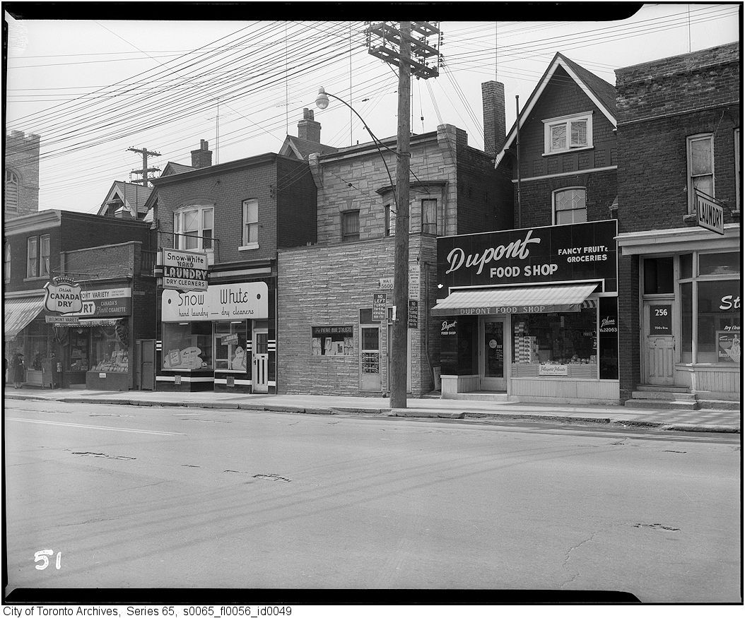
1959, pre-widening, west side of Avenue Road north of Dupont:
avdup.jpg


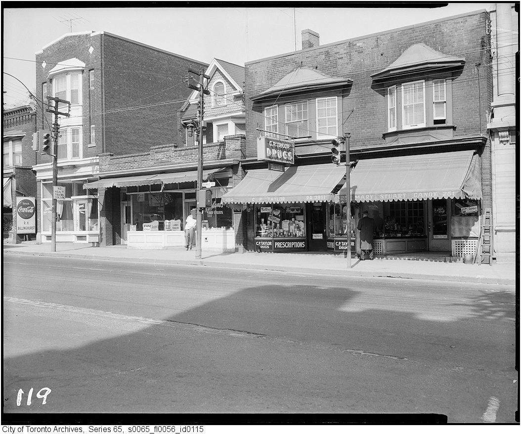
East side from Macpherson southerly:
avmac.jpg


avmac2.jpg


avmac3.jpg


avmac4.jpg
 
It's only about 4 in/15 cm of the flange of a curve which I inspected on Monday as it's becoming increasingly visible, but the ashpalt on the street is also cracking along the lines of the rails, and in some places, red paving blocks are visible under the asphalt. This bit of rail is in the middle of the street just north of the Starbucks and outside the west entrance to the BPX terminal. It's likely that much of Frederick between Front and King still has the paving stones underneath the surface as well.

The track on Sherbourne is mostly likely the remains of the tracks coming out of the Freight Shed, as route maps show the Sherbourne streetcar appearing to loop at the northwest corner at Front.

I apologise! You have sharper eyes than I do and you are certainly right, there is a small bit of curve track on Frederick and much of the street is still brick under the asphalt. When the Greyhound is demolished and the new proposed building built there I suspect they will re-do the street so neither rail nor brick will be there much longer.
 
Quite right. As attractive as the two parkettes are at Macpherson and Dupont, the village that once existed there would have been a great asset to the neighbourhood.

1959, pre-widening, west side of Avenue Road north of Dupont:

avdup.jpg


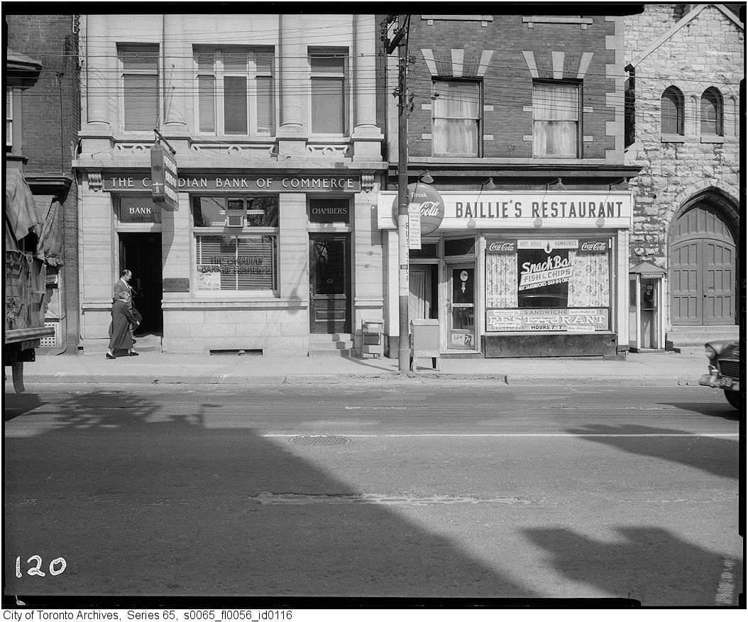
East side from Macpherson southerly:
avmac.jpg


avmac2.jpg


avmac3.jpg


avmac4.jpg

Great pictures of what was lost.

Some thoughts [in the style of LIMike :) ]:

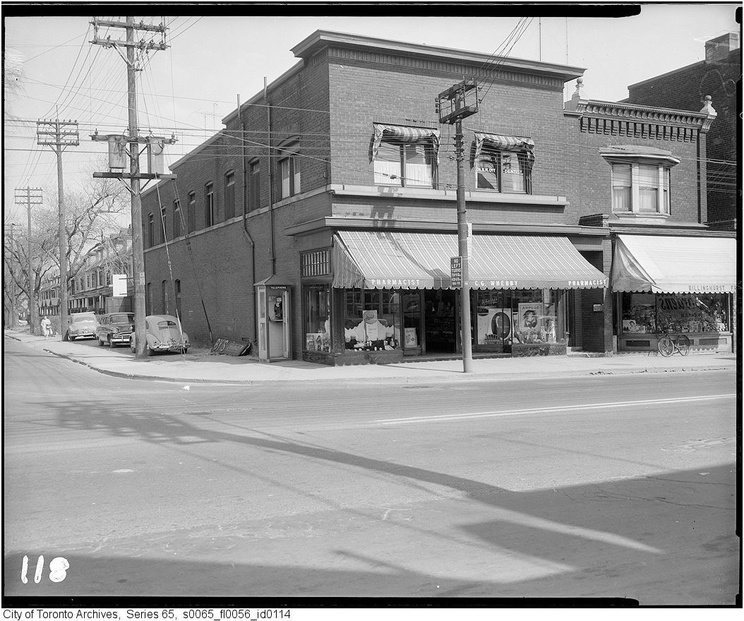
1st picture - There's the Chinese laundry again...

4th picture - Baillie's Restaurant window advertising 'Hot Sandwiches'. Lest some of you here have forgotten, or never known them (Swiss Chalet removed it from their menu a few years ago) here's what they looked like.
http://www.st-hubert.com/menu/sandw...l;jsessionid=85D4423E061125377F81883497852952

Kiddies, ask your parents to make them for you at home from roast chicken leftovers.

Other thoughts - business names like Baillie's Restaurant, Mary Stuart Candies, Whebby Pharmacy, Billinghurst...? [looks like a 'Smoke Shop'] is a roll call of Anglo Saxon Toronto.
 
Last edited:
""Originally Posted by AlbertHWagstaff View Post
It's only about 4 in/15 cm of the flange of a curve which I inspected on Monday as it's becoming increasingly visible, but the ashpalt on the street is also cracking along the lines of the rails, and in some places, red paving blocks are visible under the asphalt. This bit of rail is in the middle of the street just north of the Starbucks and outside the west entrance to the BPX terminal. It's likely that much of Frederick between Front and King still has the paving stones underneath the surface as well.

The track on Sherbourne is mostly likely the remains of the tracks coming out of the Freight Shed, as route maps show the Sherbourne streetcar appearing to loop at the northwest corner at Front.""


I apologise! You have sharper eyes than I do and you are certainly right, there is a small bit of curve track on Frederick and much of the street is still brick under the asphalt. When the Greyhound is demolished and the new proposed building built there I suspect they will re-do the street so neither rail nor brick will be there much longer.


People, any chance of a picture of this artifact? :)
 
St. Clair East (east of Inglewood), to the roundabout at Mt. Pleasant (NE corner) used to be like that for quite some time.
 
Quite right. As attractive as the two parkettes are at Macpherson and Dupont, the village that once existed there would have been a great asset to the neighbourhood.

1959, pre-widening, west side of Avenue Road north of Dupont:

avdup.jpg


East side from Macpherson southerly:
avmac.jpg


avmac2.jpg


avmac3.jpg


avmac4.jpg

Charioteer and Mustapha: Since I was mentioned I will say that these pictures remind me of older Philadelphia neighborhoods...especially the buildings with the bay windows and the interesting roofline facades in the top 2 pics...

LI MIKE
 
Last edited:
It is quite the most boring picture EVER but here it is, on Frederick just North of Front.
DSCN3924.JPG

Thanks AlbertHWagstaff and DSC for the discussion - and DSC the picture - of this seemingly insignificant relic. I find it fascinating.
 
St. Clair East (east of Inglewood), to the roundabout at Mt. Pleasant (NE corner) used to be like that for quite some time.

It was strange to see the tracks go into the roundabout and disappear under the grass wasn't it?
 
Charioteer and Mustapha: Since I was mentioned I will say that these pictures remind me of older Philadelphia neighborhoods...especially the buildings with the bay windows and the interesting rooflines in the top 2 pics...

LI MIKE

Ah, Philadelphia, the place where the citizens call their downtown 'City Centre'. A local thing. :)

I had a client there in the Philadelphia Inquirer, at N Broad and Callowhill. Quite a beautiful building.
 
June 15 addition.


Then. "March 12, 1951. Dufferin street looking N fron opp. #360." We are looking N towards Queen street.


50.jpg


Now. April 2011. We had to wait just about 60 years for the powers-that-be to bore Dufferin street through that "subway"/underpass to the relief of drivers and even us lowly bus passengers that had to endure the prior circuitous routing past the Gladstone Hotel. Oddly, it seems to have created more traffic on this route. :(


51.jpg

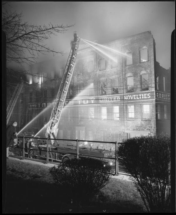
Back on June 15/page 397 of this thread, FAC33 noticed the building on the left/west side of Dufferin having most of the upper floors removed. JTCunningham guessed that it was due to fire. JT, you are right.

I0002912.jpg
 
Yeah, for years I kept looking at it and couldn't understand how much of a half-assed job it was. Also, paving over tracks is a bit strange. Do they think they're going to unearth them again?
 
Yeah, for years I kept looking at it and couldn't understand how much of a half-assed job it was. Also, paving over tracks is a bit strange. Do they think they're going to unearth them again?

It is common for cities to simply pave over old road surfaces (sometimes after scraping off the old top layer). If the base is solid it makes sense and is far cheaper. There are a few places where old streetcar rails "emerge" here - I can think of two; just south of Front on Lower Sherbourne and just north of Carleton on Church. (There are also some heavy rails re-emerging on Queen's Quay at the Harbour Castle Hotel and on Market Street at Wilton.) In Montreal, where the winters are more severe, rails are frequently seen popping up - sometimes quite significantly. The rail on Frederick Street has not, I think, popped up, rather the covering asphalt has worn away so it was probably a very cost-effective way of dealing with it.
 
It is common for cities to simply pave over old road surfaces (sometimes after scraping off the old top layer). If the base is solid it makes sense and is far cheaper. There are a few places where old streetcar rails "emerge" here - I can think of two; just south of Front on Lower Sherbourne and just north of Carleton on Church. (There are also some heavy rails re-emerging on Queen's Quay at the Harbour Castle Hotel and on Market Street at Wilton.) In Montreal, where the winters are more severe, rails are frequently seen popping up - sometimes quite significantly. The rail on Frederick Street has not, I think, popped up, rather the covering asphalt has worn away so it was probably a very cost-effective way of dealing with it.

And sometimes they don't even bother covering them up
 
Charioteer and Mustapha: Since I was mentioned I will say that these pictures remind me of older Philadelphia neighborhoods...especially the buildings with the bay windows and the interesting rooflines in the top 2 pics...

LI MIKE

I think that a lot of the visual interest in these rooflines derive from the fact that Avenue Road at this point was going through the typical Toronto transition (like on Church, Bloor, etc.) of a residential street evolving into a commercial one. The process usually started with the existing house being converted into a commercial use, followed by a one or two storey storefront addition to the front. In many cases the houseform building itself eventually got demolished and rebuilt while the front addition remained.

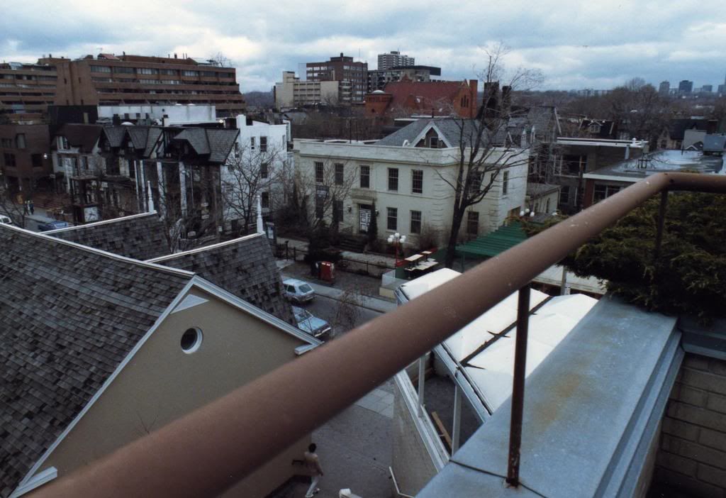
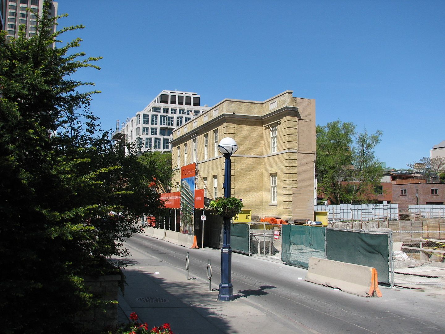
The most interesting example of this process occurred at 100 Yorkville. Originally a Victorian mansion, it was converted to the original Mount Sinai Hospital in 1923 and the Georgian facade we see today was added in 1934. The following picture shows the building in the early 1980's. Eventually the mansion was demolished and the "historical" facade was preserved, moved and integrated into the 100 Yorkville development.

2007-09-03-1857-41.jpg


28205665.jpg


64308_1.jpg
 
Last edited:

Back
Top