News   GLOBAL  |  Apr 02, 2020
 8.8K     0 
News   GLOBAL  |  Apr 01, 2020
 40K     0 
News   GLOBAL  |  Apr 01, 2020
 5K     0 

Then and Now.


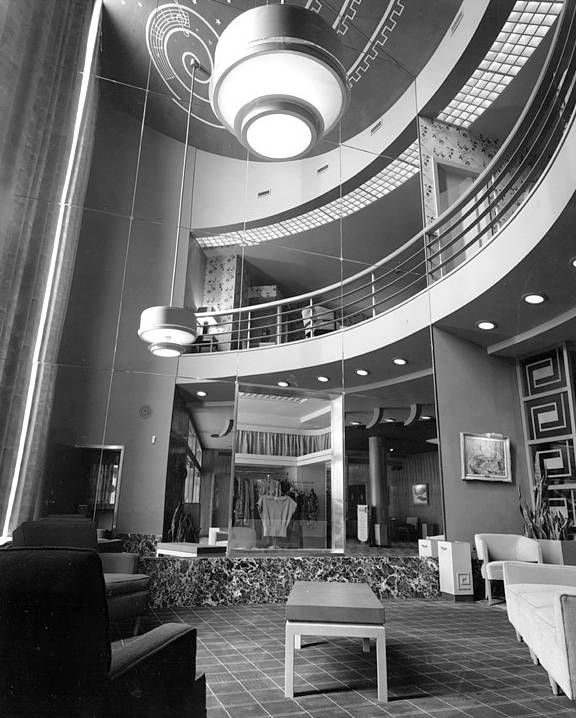
100 Bloor W. University Theatre interior. The lobby actually. c1948.

1216photo-toronto-university-theatre-bloor-street-lobby-1948_zps4f931a78.jpg


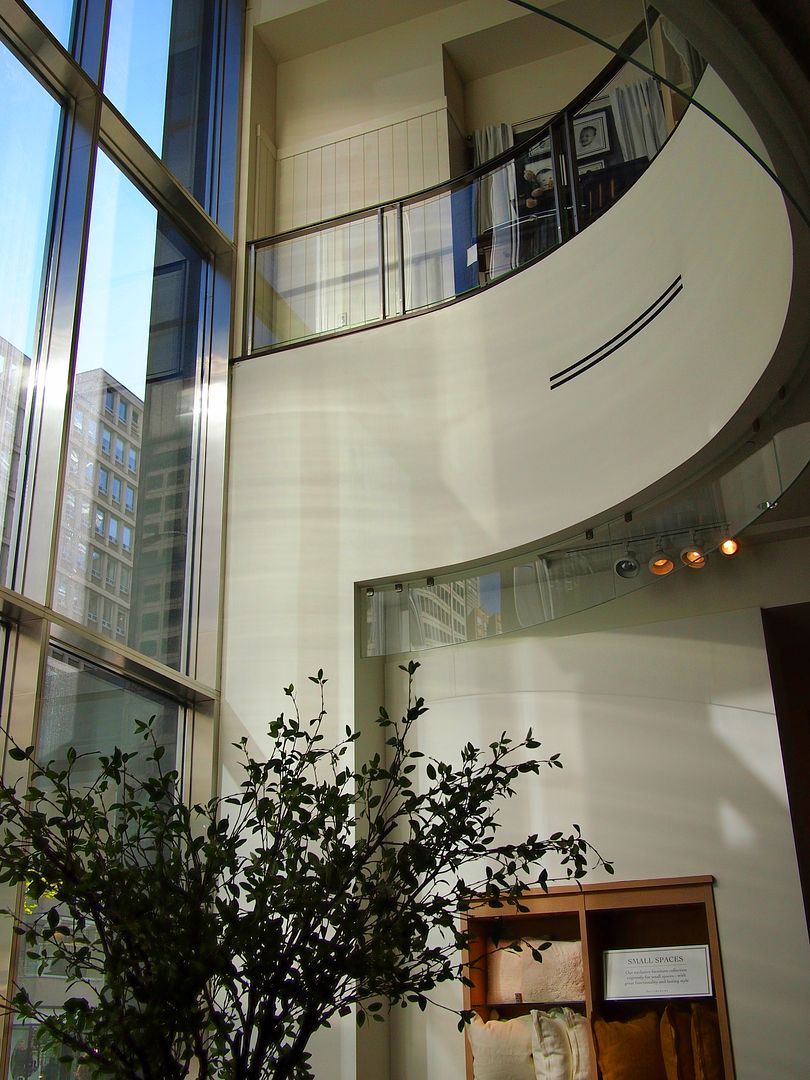
Now. Pottery Barn store. A wall behind me prevents me from backing up any more to get a similar picture. A wider lens might have done the trick but I didn't have one on me; this was a spur-of-the-moment Then and Now. :)

1217_zpsdb170f1f.jpg


As for the the Now view - we are looking at a re-creation of part of the interior. The original interior did not survive the demolition.
 
Tridel's Reve is not bad, but the beige wedding cake is nasty. The problem with Reve is that the sidewalk level looks like an afterthought and contains no retail, further bringing down the block.
 
thecharioteer:

Your use of Google 'Streetview' pictures as 'Now' pictures re-twigged a thought that I had been carrying around in the recesses of my mind for awhile now.

That thought being: With the rapid condo-ization of the city core, many buildings of, shall we say less than heritage or architectural merit, may not have been properly photographically documented for history - at least not in a single searchable database.

The only publicly and widely accessible images we have of them then is Streetview. And, available only until their camera car rolls up any particular street again and replaces earlier Streetview images of same.

Your rowhouses of Front Street exist in our 'minds eye' only here, where you have researched and presented them to us, and their source, at the online Toronto Archives.

The now gone [earlier this year] rowhouses [below] of Beverly Street [east side just north of Queen] remain to us only as visual images and only so long as I maintain my Photobucket account payments [where I have saved it] and until the camera car does an update [not yet as of today's post], or if some of you copy and save the image yourselves.

Nothing that hasn't occurred to most of you I'm sure, but I thought it worth the mention. :)

Clipboard01_zps1f5011a3.jpg
 
Last edited:
That's a really good point Mustapha - it might be difficult for us to currently see the value in preserving the memory of buildings such as the one you show above, however this might not be the case in 20 years. The importance of our vernacular architecture is just as relevant as more resplendent buildings; possibly even more so, as it's the vernacular that we interact with on a daily basis and that evidence how we want buildings to operate.

We might want to be defined by the beautiful, costly and one-off buildings we construct, but we are in actuality better known by the everyday boxes we inhabit.
 
Mustapha, I took a philosophy course at University in the early 2000s. They said the internet was like the libraries of yore. Back then, before the printing press (or even before mass publishing), there was one copy of a book and if the owner destroyed it, it was gone (Great Library of Alexandria, for example). Today, while anyone can access an image, a blog, or any other website, few save it, and if the owner takes it down then it's lost to the world.
 
Last edited:
One would hope that Google is keeping all the images it takes, even after they go out and gather new ones. It would be cool to be able to look at a particular address in 20-30 years and see each of those images side by side to compare.
 
One would hope that Google is keeping all the images it takes, even after they go out and gather new ones. It would be cool to be able to look at a particular address in 20-30 years and see each of those images side by side to compare.
I had assumed that the older published images WERE being kept but maybe not. It would be great to have access to Streetview photos spread over several years and see how areas have changed. This blog entry may be of interest. http://www.gearthblog.com/blog/archives/2012/02/is_historical_imagery_coming_to_str.html
 
Last edited:
Thanks for bringing that subject to our attention, Mustapha.
You've struck my 'hot-button.'
I've been saying, ever since I joined the digital generation, that I'm afraid photographs only stored as bits & Bytes in computer systems will be lost to history.
We should all know by now that hard-drives fail, the delete button can be dangerous and our old diskettes (full of images) can no longer find a read-slot in new hardware.
Also, there's no guarantee that Google or any other image-storing site will preserve their images if sold or simply abandoned in bankruptcy.
Remember, we have access to those wonderful City of Toronto Archive images only because the originals are in the files as "paper prints, slides or film negatives."
My message: MAKE PAPER PRINTS OF ANY IMAGES YOU WANT TO PRESERVE!

Let's not assume that Google will be our 'back-up.'
 
The streetscape looked unremarkable then and unremarkable now.

You're absolutely right, junctionist, but I think that the unremarkability of Front Street would have to blamed on the steady growth of the railway yards south of Front Street. For the first half of the 19th century, the idea of Front Street as an actual "front" to the city was exemplified by the Third Parliament Buildings and stately homes such as the Coulson House and Bishop Strachan's "Palace". If the waterfront had actually evolved as the "walks and gardens" once envisioned, the resulting built-form would have been quite different.

Maps from the 1850's to 1910's tell the story:


1852:


1857:


1858:


1889:


1893:


1910:


View of Front Street between Peter and John in 1810:


View NW from Front and Simcoe, 1834, by John Howard:


Front Street in the 1840's, from Front and Peter, looking SE (1890's sketch by Owen Staples):


View in 1841:


From the 1857 Rossin House panorama:


1894:


1926:


Last edited:
Front Street East

NE corner of Front and Ontario, the Christopher Widmer House, 1885 (TPL):


NE corner of Front and George, the Duncan Cameron House (later the Black Horse Hotel), 1885:


NW corner of Front and Frederick, William Warren Baldwin House, 1879:


Last edited:
The series of maps above remind me that the naming of streets as East or West did not seem to be universally applied and leads me to ask when the "rule' of using Yonge Street as the dividing line began. From the online Directories it seems to be after about 1845.
 

Back
Top