News   GLOBAL  |  Apr 02, 2020
 9.8K     0 
News   GLOBAL  |  Apr 01, 2020
 41K     0 
News   GLOBAL  |  Apr 01, 2020
 5.6K     0 

What a masterpiece! Even if the DRL is never expanded further west of Exhibition GO, you could see how the proposed Waterfront West LRT could naturally and easily branch out from this point south to Ontario Place then west along Lakeshore Blvd into southern Etobicoke. Interlining with the streetcar tracks on Dufferin and expansion of trackbed north of Queen could occur as well, for a continuous LRT service from Union to Fairbanks Stn on the Crosstown via Dufferin Mall, Dufferin Stn and Corso Italia. Hell, even extend the 47 south along Jameson and Springhurst to Exhibition Stn for more connectivity. Genius.
I suppose with that alignment, there is no need for a Dufferin Station if the Dufferin bus just terminates at Exhibition Station.

Westward extension could continue along the tracks to stops at Jameson, and Sunnyside. Then, either north to the Bloor Line or over the bay to South Etobicoke.
 
If it extends to Long Branch they should build an additional line from Long Branch running north or Humber College via the airport and connect with the Georgetown line.
 
The "Exhibition" Station would have to be more closer to Ontario Place. Currently, the Exhibition Loop is too far, forcing people to safari across an asphalt desert. If it has to take space away from the current parking lot, the better.
Why not simply place at the southern end of the subway platform tunnel a stairway running up to the northern end of the footbridge to Ontario Place, on the north side of Lakeshore. The northern end of the subway platform tunnel would connect to Exhibition GO. Basically put the station platforms under the CNE, which is easily dug cut and cover through the surface parking lot.

Absolutely there should also be an Ontario Line station at Liberty Village GO/ST station. Aquateam's plan works great.
 
Last edited:
I'd love to see this go across Queen/Parkdale.
That’s why retaining the Liberty Village Smart Track station between King and Queen at standard TTC fare is critical, because if the Ontario Line has a stop there, there’s a complete TTC rail connection between the Ontario Line and the Bloor Danforth Line in the west. Basically the Ontario Line becomes much much longer. Even if the Ontario Line follows its current plan, winding down at King and Bathurst with Ontario Place as the final stop, the Liberty Village ST station is essential for the very under serviced area of north Liberty Village and Shuster. It also services the eastern end of Parkdale.
 
Perhaps a loop is the solution:

Ontario%20Line-CNE%20Loop%20Option_zpslwrq8u5s.png


I'd have the streetcar tracks extend south of Exhibition Loop with an intermediary stop at BMO Field with a final station at Ontario Place. This frees up the subway to loop back up through Parkdale then up Parkside-Keele-Weston to Mt Dennis or Weston Village.
 
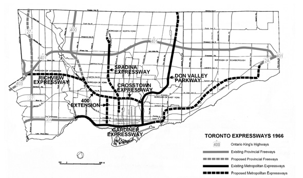
The Eglinton West LRT will be (allegedly) built in Etobicoke along lands that would have been used for the Richview Expressway.

2011913-expressways-plan-1966.jpg

From link.

What about the "lands" that could have been used for the "400 Extension" down to the Gardiner Expressway, meeting near Exhibition Place? Could an "Ontario Line" westerly extension use any of pathway or right-of-way for the "400 Extension"? If any real estate has already been expropriated for some "future use"?
 
What about the "lands" that could have been used for the "400 Extension" down to the Gardiner Expressway, meeting near Exhibition Place? Could an "Ontario Line" westerly extension use any of pathway or right-of-way for the "400 Extension"? If any real estate has already been expropriated for some "future use"?

I am not aware of any unused lands in the potential path of the 400 extension. Looks like if that extension was to proceed, land would have to be expropriated, or else the highway would have to be built underground.
 
I am not aware of any unused lands in the potential path of the 400 extension. Looks like if that extension was to proceed, land would have to be expropriated, or else the highway would have to be built underground.

Metro started buying up houses on the corridor in the 1960s as a first step, but didn't do much else. Many of these were later managed by TCHC and were sold off during the Ford mayoralty.
 
You mean at highway 7 (and Leslie). There is not much for 5.5 km between Seneca and 407. The extension to Seneca College I can see being needed. Beyond that I just don't know.
There is a huge employment cluster at Woodbine and Steeles. After that though, yes, there is a bit of a gap until Highway 7. I picture it running elevated up along the 404 and Woodbine then following Yorktech Drive and Enterprise over to Unionville. Maybe 2 phase it with the first phase to Steeles only.
 
The "Blue Line" should also extend west of Long Branch but then this thread would have to renamed "This is all Speculation"

There's not much of anything to serve along the Lakeshore in Mississauga until you hit Cawthra, and then after that Hurontario itself. Even the 23 Lakeshore only runs every 20 minutes on average because the usage is so sparse.
 
A Liberty Village station should be underground and connected to both Exhibition and the new King/Liberty GO stations through a concourse, with an underground streetcar loop in that concourse.
 
A Liberty Village station should be underground and connected to both Exhibition and the new King/Liberty GO stations through a concourse, with an underground streetcar loop in that concourse.
So a Union Station South West? Spadina GO is Union Station South South West and Pearson is Union Station West.
 

Back
Top