News   GLOBAL  |  Apr 02, 2020
 9.8K     0 
News   GLOBAL  |  Apr 01, 2020
 41K     0 
News   GLOBAL  |  Apr 01, 2020
 5.6K     0 

How did Carlisle become Carlyle?

Probably the original map misspelled it and it was Carlyle the whole time.

I believe that same map misspelled Sammon as Salmon in my neighbourhood, but the street was never actually called Salmon.
 
Probably the original map misspelled it and it was Carlyle the whole time.

I believe that same map misspelled Sammon as Salmon in my neighbourhood, but the street was never actually called Salmon.
There are street signs still out there from 100 years ago have spelling mistakes on them. I suspect that the actual spelling wasn't as clear to everyone back then, particularly if the signs themselves could be wrong. Here a couple of examples:

cassels-300.jpg
Belhaven-Bellhaven-300.jpg
 
Last edited:
Not sure if it has been discussed before, Google maps shows that Front St E is planned to be extent to all the way to the planned southern extension of Bayview Ave which runs to the southen edge of Corktown Commons. Mill St is planned to be extended there too?

Other possible connections
Ontario st and Berkeley st between Queen and Shuter. I think those Moss Park apartments should be separated to avoid a ghetto effect.
Sumach to to connect between Shuter and Dundas (already done?)
Church St to extend and connect with Cooper St (and call the whole thing Church st). Right now Church ends at a Parking structure just before the railtracks.

Scott and Victoria should be combined as Victoria st.
Also, Ted Rogers Way is ridiculous for such a short stretch. Should be just Jarvis but it is probably paid for.
 
Not sure if it has been discussed before, Google maps shows that Front St E is planned to be extent to all the way to the planned southern extension of Bayview Ave which runs to the southen edge of Corktown Commons. Mill St is planned to be extended there too?
Mill Street is already built to Bayview; and all the services for Front is in, it should be finished soon. They just haven't been opened yet (and won't until 2016). You can see a more recent 2013 airphoto in Google Earth that shows this, and also the streetcar tracks on Cherry.

Though is really a missing link? Front always reached Bayview, and Mill always went about as far as where Bayview has been moved to. They've only been closed temporarily.

Sumach to to connect between Shuter and Dundas (already done?)
I believe that's planned as part of a future Regent Park Phase. They've already connected from Dundas to Gerrard and connected Sackville from Gerrard to Shuter.
 
There are street signs still out there from 100 years ago have spelling mistakes on them. I suspect that the actual spelling wasn't as clear to everyone back then, particularly if the signs themselves could be wrong. Here a couple of examples:

cassels-300.jpg
Belhaven-Bellhaven-300.jpg

Sometimes we get stuck with the misspellings. Joseph Bloore lived in Yorkville and had a brewery, but then they misspelled Bloor Street after him.
 
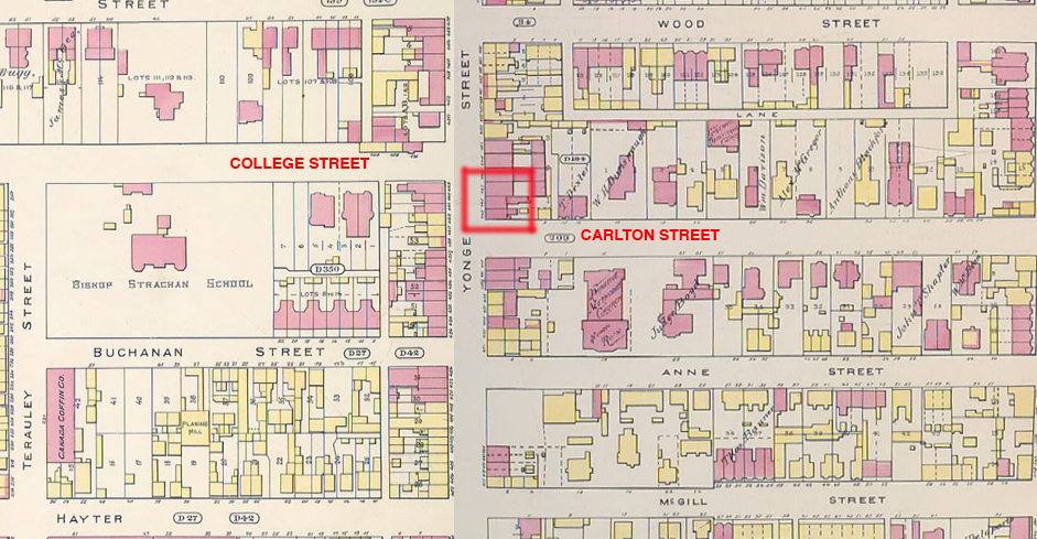
College Street and Carlton Street did not connect until the 1930's.

carlton-college.jpg


A couple of other projects pushed it. Eaton's College Street Store and Maple Leaf Gardens.

From this link.
 
Had some thoughts regarding connecting the eastern and Western portions of St Clair. At one time, it would not have been a ridiculous proposition to extend the eastern portion of St Clair from its terminus through the Taylor Creek Ravine and Coxwell Ravine Park to meet up with the Don Valley Parkway. Exit ramps then could have been constructed to a new roadway that travelled up the Moore Park Ravine to meet up with the existing western portion of St. Clair.


Of course this kind of roadway would be a complete non-starter today, especially given that it isn't clear if there is need for a road such as this and the fact it cuts through large swaths of ravine and established, quiet, affluent residential neighbourhoods.

There is one very short piece of this road alignment would would be incredibly useful, and that's the ramps to Bayview Ave, particularly if the DVP/Gardiner becomes a toll road (which isn't unlikely).


So, why would Bayview need another set of ramps? Mainly because the existing partial ramps are are a stub of the Crosstown Expressway which are serving a function they were never intended to. Going southbound on Bayview to the DVP while currently possible is circuitous and involves weaving through a section of cloverleaf. Other traffic movements are simply not possible such as getting to Bayview to Bloor Ave. Downtown-Bound traffic on Bayview really has no alternative than continue along Bayview to River St and navigate through local roads into downtown.
 
Last edited:
Reconnecting the two halves of St Clair (which AFAIK were never actually connected by a formal road) isn't going to happen, given the presence of the ravine & trails, residential areas and the railway. If you really want to travel from one St Clair dead end to another, it's not a huge inconvenience to use Moore, Southvale, Millwood/Donlands and O'Connor; other than that, the two halves function as entirely separate streets.

Someone mentioned the Dupont/Dundas/Annette intersection. At the risk of sounding like a broken record, I think that needs to be regraded and made into a roundabout, or at least simplified with the removal of that stupid traffic island.
 
That intersection needs to be rebuilt. The signal cycle wastes peoples' time by including a phase for Old Weston Road--I never see anyone coming off Old Weston Road during its signal. It backs up traffic on Dupont. The connector from Dundas to Dupont makes it treacherous to walk and bike on Dundas.
 
Reconnecting the two halves of St Clair (which AFAIK were never actually connected by a formal road) isn't going to happen, given the presence of the ravine & trails, residential areas and the railway. If you really want to travel from one St Clair dead end to another, it's not a huge inconvenience to use Moore, Southvale, Millwood/Donlands and O'Connor; other than that, the two halves function as entirely separate streets.

Someone mentioned the Dupont/Dundas/Annette intersection. At the risk of sounding like a broken record, I think that needs to be regraded and made into a roundabout, or at least simplified with the removal of that stupid traffic island.

Of course in this day and age, connecting up St Clair would never happen. I do however think that another set of Bayview ramps in warranted and feasible.

I also think it's worth the effort to normalize the Dupont/Dundas/Annette intersection (4-way with lights or a roundabout) by rerouting Annette to meet with the Dupont underpass by demolishing the auto shop on the south corner of Dundas/Annette.
 
That intersection needs to be rebuilt. The signal cycle wastes peoples' time by including a phase for Old Weston Road--I never see anyone coming off Old Weston Road during its signal. It backs up traffic on Dupont. The connector from Dundas to Dupont makes it treacherous to walk and bike on Dundas.

The signal off Old Weston Road coincides with the walk signal for pedestrians to cross Dundas safely and it is the "proper" way to cycle from Dupont to Annette (proceed with the cars going from Dupont to Dundas, and wait for the signal for Old Weston to cross Dundas to get to Annette). It's confusing.
I agree - rebuild it and make it a simple four-way intersection and turn Hook/Old Weston into a cul-de-sac east of Watkinson.
 
The other thing about Dupont/Dundas/Annette that makes very little sense is that westbound traffic on Dupont is supposed to divert at the traffic island depending on whether it's going south on Dundas or north on Dundas/continuing on Annette. Not that drivers intending to go south on Dundas always realize that ...
 

Back
Top