So I got thinking after a post I made in the new streetcars thread. I've been meaning to actually flesh out this idea I've always had of a much expanded streetcar network and, needing something to procrastinate with, I came up with this:
https://www.google.com/maps/d/edit?hl=en&hl=en&authuser=0&authuser=0&mid=zM7XQoNr2gLw.kYv5ZAzUJmuE
I'm definitely putting the "fantasy" in transit fantasy maps but I really do love the city's streetcar network and I really wish we had a larger one. Obviously a lot of the services I've included would be repetitive and uneconomical but I think it's still a pretty cool thought.
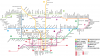
In terms of the map itself, I have added 20 potential routes, ranging in length from about 16km (Kingston Rd. and Morningside to approximately Queen St., probably still longer) to a little over 2.5 km (the Mt. Pleasant route without an extension south to Jarvis). Some are historic and abandoned streetcar lines, others are ones I feel make sense (due to their geographic placement or my idea of current travel patterns) and so take a lot of my ideas here with a grain of salt. If all of these were built, the city streetcar network would grow to about 211-221km (depending on whether you add certain extensions and count the bayfront LRTs). I estimated it would cost about $12-12.5 billion, assuming about $100 million/km.
For context (and further procrastination) I added a number of rapid transit projects (subways and LRTs, as per the TTC's definitions of the Sheppard and Finch LRTs as rapid transit). I just reused the Transit City plan for the LRTs as that's my preference and I had easier access to cost estimates. There is also the Yonge North extension, DRL, Sheppard West connection and Finch LRT east of Finch West Station. My ideas would add about 108.3 km of rapid transit, more than doubling the current system (based upon the wiki estimates of the current size plus under construction lines).
Finally, just to complete my ridiculous need to procrastinate, I added the GO lines and potential extensions. The huge ass Pickering/Locust Hill/Midtown line is probably wrong, the complete emptiness of that area of the GTA made it hard to get my bearings while making this (and I didn't care nearly enough to actually find a proper routing). I believe I also use an abandoned spur for the Seaton line (if I recall a discussion on this, that branch of track is abandoned Canadian Pacific lines) and screwed up the alignment for the Lakeshore East extension to Bowmanville. If everything was built as I've put on the map, it would about around 300 km of commuter rail, bringing the GO system to 843.3 km (though 145 of that is my almost certainly wrong Pickering line, so keep that in mind). As I've said, this was mostly about putting to paper (so to speak) my fantasy streetcar network, as well as procrastinating...