News   GLOBAL  |  Apr 02, 2020
 8.6K     0 
News   GLOBAL  |  Apr 01, 2020
 39K     0 
News   GLOBAL  |  Apr 01, 2020
 4.8K     0 

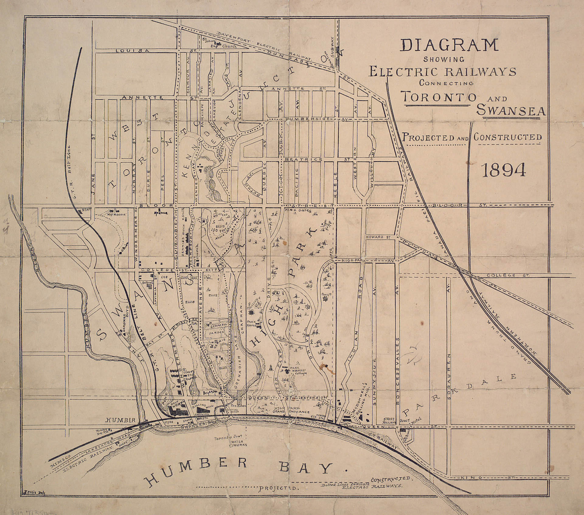
If I was dictator, I would have the Jane LRT follow the old Belt Line Railway right-of-way south of Bloor Street, down to the general area of the lake.

map_Junction_Swansea_1894.jpg

From link. 😄 😄
Most of which is now laneways or backyards.

When they constructed the Bloor-Danforth (now Line 2) extension, they bridged the tracks between Kennedy Avenue and Quebec Avenue because of now buried creek above High Park. The Kennedy estate should have been added to High Park, but they wanted the money by filling in the creek and building houses (along with resulting basement swimming pools).
 
Based on the newly shared map by the Ontario government. Looks like Jane LRT is back on the table!?

Looks like that there will still not be a connection to the Waterfront (and possibly Ontaro line extension or Waterfront LRT, which one of the two is hard to tell from the low resolution map)

Screenshot_20210701-132741_Drive.jpg
 
Last edited:
it's literally the exact route for the waterfront LRT, not an extension of the OL
The document is mentioning an Ontario Line loop and there are some speculations on other threads here that the old Waterfront rout is the South part of that loop. Whereas, the Northern part goes to Person Airport.

That is why I included both options in my post above, just in case. Although, I would personally prefer OL over an LRT.

Still, it would make a lot of sense to connect Jane LRT to the Waterfront. Probably via South Kingsway.
 
I wouldn't put much thought into a really hard to read, pixelated map. Seriously, it's the 2020s. I did better pictures with Paint in the 1990s.
So frustrating to see such maps in 2020s!

I'll leave a link below:


The good thing is that the government is asking for public to comment this future plan and if many of us voice our opinion that Jane LRT should be built and that it should be extended to the Waterfront, maybe that would help secure funds for the project.

Adding link for the public feedback:


I left detailed feedback.

But something I omitted people should submit is that the mapping is terrible, low-resolution, blurry, unlabelled.

That that is completely incompatible with intelligent feedback.

and

That there's also an absence of even the highest level of project list, and costing.

How is one supposed to intelligently rate options without understanding that if you pick A, there is insufficient money for B, C, and D?

This level of plan is not an EA. Routes will be conceptual, costs with no design complete will have ranges of +/- 100% on them.

That's fine. But you need something to work with other than vague principles and ideas with no substance.
 
Last edited:
So frustrating to see such maps in 2020s!

I'll leave a link below:


The good thing is that the government is asking for public to comment this future plan and if many of us voice our opinion that Jane LRT should be built and that it should be extended to the Waterfront, maybe that would help secure funds for the project.

Adding link for the public feedback:

The original Jane LRT was unlikely to be built because they found out later that to build the Jane LRT they would have to tunnel the entire section south of Lawrence, and to extend south to the Waterfront would almost definitely require even more tunnneling to the point where more than half the line from Steeles would have to be tunneled. In other words, how about we don't make this an LRT and learn from our mistakes with Eglinton?
 
The original Jane LRT was unlikely to be built because they found out later that to build the Jane LRT they would have to tunnel the entire section south of Lawrence, and to extend south to the Waterfront would almost definitely require even more tunnneling to the point where more than half the line from Steeles would have to be tunneled. In other words, how about we don't make this an LRT and learn from our mistakes with Eglinton?
Subways anywhere and everywhere. Maybe you can run for premier. It looks like ours is about to be out of office.
 
Subways anywhere and everywhere. Maybe you can run for premier. It looks like ours is about to be out of office.
Unfortunately for you what I'm saying is the truth. In 2009 the Jane LRT was basically on its way out because they were realizing that the CBR for an LRT was extremely small and there were many calls to scrap that line and migrate it over to Islington or Kipling (which are far more suitable for LRT). The reasoning of the corridor being extremely tight is also the same reason why the RapidTO program is only considering BRT lanes as far as Eglinton and not Bloor
1625204646525.png

Simply put, with the amount of tunneling needed to be done on this line, we're better off just building a Canada Line style line (which is what should've been done on Eglinton).
 
Unfortunately for you what I'm saying is the truth. In 2009 the Jane LRT was basically on its way out because they were realizing that the CBR for an LRT was extremely small and there were many calls to scrap that line and migrate it over to Islington or Kipling (which are far more suitable for LRT). The reasoning of the corridor being extremely tight is also the same reason why the RapidTO program is only considering BRT lanes as far as Eglinton and not Bloor View attachment 332044
Simply put, with the amount of tunneling needed to be done on this line, we're better off just building a Canada Line style line (which is what should've been done on Eglinton).
hm... if only we were getting a light metro line somewhat like the Canada line that could head over to this corridor relatively easily 🤔
 
Unfortunately for you what I'm saying is the truth. In 2009 the Jane LRT was basically on its way out because they were realizing that the CBR for an LRT was extremely small and there were many calls to scrap that line and migrate it over to Islington or Kipling (which are far more suitable for LRT). The reasoning of the corridor being extremely tight is also the same reason why the RapidTO program is only considering BRT lanes as far as Eglinton and not Bloor View attachment 332044
Simply put, with the amount of tunneling needed to be done on this line, we're better off just building a Canada Line style line (which is what should've been done on Eglinton).
Eglinton to Steeles is much busier than south of Eglinton. The planned service after the route splits (after the corsstown opens) would allocate more service north of Eglinton. It's also more prone to congestion, especially around the 400 interchange area.
 
hm... if only we were getting a light metro line somewhat like the Canada line that could head over to this corridor relatively easily 🤔
My dream set up for the OL has always been that the east gets extended to Leslie-Highway 7, and the western end extends north to Pioneer Village along Jane, and then regional travel gets supplemented by the transitway, or if we're being daring - the 407 REM. This weird doubling down on the corridor setup that Ontario seems to be planning is sort of strange. What might be interesting though is if we pull a London and make the Ontario Line a spiral - start at Kipling, go to Pearson, go to RHC and Leslie, go downtown, then travel back north along Jane.
 

Back
Top