News   GLOBAL  |  Apr 02, 2020
 8.9K     0 
News   GLOBAL  |  Apr 01, 2020
 40K     0 
News   GLOBAL  |  Apr 01, 2020
 5.1K     0 

our rapid transit is embarrassingly empty with two lines and two short spurs with 4/5 stops. There is no worry about space being clogged up for a long time even when all the current projects are completed.
Only 3 stations of the Spadina extension are located in Toronto, so there is minimal change in northwest part of the map - which means still largely empty.

I disagree. With a RT system that will likely look like this in 15 years, the narrow RT maps in the subway trains are going to get awfully cluttered. TTC may need to switch to showing one line on the narrow map, rather than all 13 rapid transit lines. This is assuming that the RER lines are going to be shown on the maps, which may or may not happen (the TTC may not want to lose passengers to GO).

ZcPmQPl.jpg
 
The 510 is slow because there are a lot of intersections with other streetcar routes, and the driver has to check the switch at every intersection before proceeding, resulting in having to stop at almost every red light. A lot of intersections in general doesn't help either.

Ohh okay, that makes sense. What about the 512?
 
Ohh okay, that makes sense. What about the 512?
Kind of guessing here, but the 512 is slow because the signal priority sucks and having to wait for the left turners at every intersection doesn't help. Also, the stops are very close together (i.e. Bathurst and Vaughan Rd.). The 506 on the other hand can be VERY fast between Main Street and the Don because there's never really much traffic there and many of the stops don't have traffic lights near them.
 
I said it would look like that in 15 years. That means that those 13 RT lines can be operational in 15 years or less
1) Why have you not shown any service between 407 station and Vaughan Centre station?

2) Why are you thinking there's going to be RT on all 7 of the GO lines, some of which are only promised to be RER?
 
1) Why have you not shown any service between 407 station and Vaughan Centre station?

2) Why are you thinking there's going to be RT on all 7 of the GO lines, some of which are only promised to be RER?
1) My bad.

2) in the most recent RER report, the scope of the project is:"An electrified service on corridors Metrolinx owns with 15-minute frequencies in core areas".

Within toronto, Metrolinx owns all corridors except Milton. I don't think there's any plans that have been made public to purchase the Milton corridor. But RER should be delivered everywhere else. Mind that Miron is inconsequential to our RT goals within toronto, as it almost fully duplicates Line 2 and Kitchener RER.
I still wouldn't call every 15 minutes electrified GO Train service rapid transit.
 
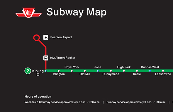
Why is everyone so bothered by showing airport connections on the subway map? It's an important connection in the system, especially for tourists who are not familiar with the TTC. From first hand experience, most tourists don't even realize the TTC reaches Pearson.

Who cares if the Airport Express is not a "rapid transit" line. The map's main focus should be making it easier for riders to know where they are going on major routes, not being a "RT only" map. You'd be delusional to think transit connection to the airport is not major. As of right now, tourists are not finding it clear how to use the TTC to get to the airport, and that's a problem.

If they put it on the map, then it would be fair to also include the UPX.

Not really, considering UPX is not part of the TTC.
 
Kind of guessing here, but the 512 is slow because the signal priority sucks and having to wait for the left turners at every intersection doesn't help. Also, the stops are very close together (i.e. Bathurst and Vaughan Rd.). The 506 on the other hand can be VERY fast between Main Street and the Don because there's never really much traffic there and many of the stops don't have traffic lights near them.

No guess needed. The only reason is there are way too many stops.
No rapid transit in the world stops every 200 meters on average.
 
I disagree. With a RT system that will likely look like this in 15 years, the narrow RT maps in the subway trains are going to get awfully cluttered. TTC may need to switch to showing one line on the narrow map, rather than all 13 rapid transit lines. This is assuming that the RER lines are going to be shown on the maps, which may or may not happen (the TTC may not want to lose passengers MG]

There is simply zero possibility tonronto RT will look like this in 15 years. We probably won't add half as many.
 

I wonder if this will spur Ford to call for an extension of the Bloor line to the airport?

Look at all those poor people in Etobicoke with no subway service, having to rely on a bus instead! It is just like Scarborough with the SRT! Meanwhile those downtown elites get those sexy 20 year old subway trains and sleek subway stations with their 1970s pastel colours!

gunkjpg.jpeg.size.xxlarge.letterbox.jpeg

3422c0f94b2cb421a9c4e667d051-473x315.jpg

20090305islingtonsicydilemma.jpg

Dundas_West_Station_-_TTC.jpg

IMG_1242C.jpg

20100713_mb.jpg


Damn elitists!
 
Why is everyone so bothered by showing airport connections on the subway map? It's an important connection in the system, especially for tourists who are not familiar with the TTC. From first hand experience, most tourists don't even realize the TTC reaches Pearson.

Who cares if the Airport Express is not a "rapid transit" line. The map's main focus should be making it easier for riders to know where they are going on major routes, not being a "RT only" map. You'd be delusional to think transit connection to the airport is not major. As of right now, tourists are not finding it clear how to use the TTC to get to the airport, and that's a problem.


Not really, considering UPX is not part of the TTC.

It violates the purity of our beloved RT map.
 
Ford will not call for the extension of the Bloor line west than it is now. He had the chance starting in 2005 when first proposed by Peter who ward the line is in and again later on, but most of all when he was Mayor. He was willing to sell a subway in the east to get more Ford Nation as the west was already Ford Nation.

If he did, we would be a few years away from seeing it opening and not having to deal with the mess at Kipling now or come 2019/20.
 
Yes, but this bus route is not rapid transit.

Neither is the Brown line in Chicago, it would be disturbing if it didn't show up on their maps.

The map should show routes that are uniquely useful (you can get from anywhere to anywhere via the grid, but some routes are much better than others).

If you want, we can stop calling it a rapid transit map and call it a "get where you are going quickly" map.
 

Back
Top