News   GLOBAL  |  Apr 02, 2020
 9.8K     0 
News   GLOBAL  |  Apr 01, 2020
 41K     0 
News   GLOBAL  |  Apr 01, 2020
 5.6K     0 

New video this week, looking at the Sherbourne Streetcar. This one is an odd one since for whatever reason it was built to a different loading gauge from the rest of the network. The line had a thinner "Devilstrip" (Devilstrip being the space between the tracks) so only thin body cars could safely operate the line in active service. Peter Witt cars and PCC cars never made it onto the line (although PCC did operate the rush hour SHERBOURNE TRIPPER).
 
On the topic of giving streetcars priority, I was thinking that perhaps we could copy Melbourne in their format for giving transit ROW in tight 4-lane streets:
sydney-rd-improvement-project-images_option-1b.ashx

The image is from a proposal by the Victorian government on what layout to use for Sydney road in Melbourne. I really like this layout for a number of reasons:
1. the extended curb reinforces that the area gives alighting passengers priority over vehicles. It also forces vehicles to slow down when running over them.
2. Parking is still available during the off-peak so this will, hopefully, go down better with businesses (although I wouldn't mind giving streetcars priority 24/7).
3. The design is pretty flexible. In Melbourne at least, vehicles can quickly divert around an obstruction via the transit ROW given that they yield to streetcars.
 
Last edited:
On the topic of giving streetcars priority, I was thinking that perhaps we could copy Melbourne in their format for giving transit ROW in tight 4-lane streets:
sydney-rd-improvement-project-images_option-1b.ashx

The image is from a proposal by the Victorian government on what layout to use for Sydney road in Melbourne. I really like this layout for a number of reasons:
1. the extended curb reinforces that the area gives alighting passengers priority over vehicles. It also forces vehicles to slow down when running over them.
2. Parking is still available during the off-peak so this will, hopefully, go down better with businesses (although I wouldn't mind giving streetcars priority 24/7).
3. The design is pretty flexible. In Melbourne at least, vehicles can quickly divert around an obstruction via the transit ROW given that they yield to streetcars.
Looks like lots of conflicts between bikes and pedestrians at stops.
 
On the topic of giving streetcars priority, I was thinking that perhaps we could copy Melbourne in their format for giving transit ROW in tight 4-lane streets:
sydney-rd-improvement-project-images_option-1b.ashx

The image is from a proposal by the Victorian government on what layout to use for Sydney road in Melbourne. I really like this layout for a number of reasons:
1. the extended curb reinforces that the area gives alighting passengers priority over vehicles. It also forces vehicles to slow down when running over them.
2. Parking is still available during the off-peak so this will, hopefully, go down better with businesses (although I wouldn't mind giving streetcars priority 24/7).
3. The design is pretty flexible. In Melbourne at least, vehicles can quickly divert around an obstruction via the transit ROW given that they yield to streetcars.

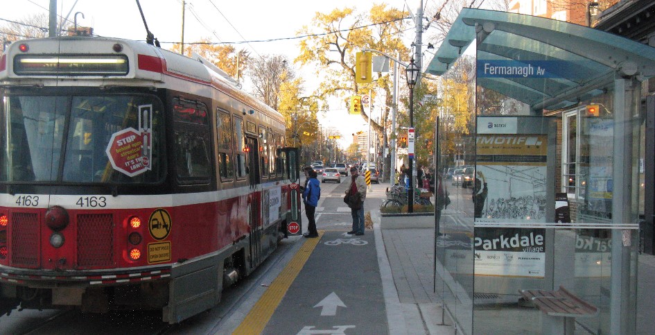
That's Roncesvalles Avenue. Because of the King-Queen-Roncesvalles-Queensway intersection reconstruction, they are using buses.
Roncesvalles-Ave-2.jpg

From link.

proxy.ashx

From link.
 
On the topic of giving streetcars priority, I was thinking that perhaps we could copy Melbourne in their format for giving transit ROW in tight 4-lane streets:
sydney-rd-improvement-project-images_option-1b.ashx

The image is from a proposal by the Victorian government on what layout to use for Sydney road in Melbourne. I really like this layout for a number of reasons:
1. the extended curb reinforces that the area gives alighting passengers priority over vehicles. It also forces vehicles to slow down when running over them.
2. Parking is still available during the off-peak so this will, hopefully, go down better with businesses (although I wouldn't mind giving streetcars priority 24/7).
3. The design is pretty flexible. In Melbourne at least, vehicles can quickly divert around an obstruction via the transit ROW given that they yield to streetcars.
That's literally Roncesvalles Avenue.
 
That's literally Roncesvalles Avenue.

Well, not exactly...but I guess its the same idea.

On Roncesvalles, there are extended curbs, but they are designed for bikes and not wide enough for automobiles. The design I was referring to would kick automobiles out of the two centre lanes to turn them into dedicated transit lanes for streetcars. Automobiles are relegated to the two most outer lanes with passengers continuing to alight at curbside (hence the extended curb). Off-peak hours, on street parking is allowed and automobiles can share the centre lanes with streetcars.
 
New video this week, looking at the Sherbourne Streetcar. This one is an odd one since for whatever reason it was built to a different loading gauge from the rest of the network. The line had a thinner "Devilstrip" (Devilstrip being the space between the tracks) so only thin body cars could safely operate the line in active service. Peter Witt cars and PCC cars never made it onto the line (although PCC did operate the rush hour SHERBOURNE TRIPPER).
It was built to the exact same standard as every other line was built at that time.

What changed was the change of the standard when the TTC took over transit operations in 1921.

Virtually the rest of the system was upgraded to the new standards over the course of the following 4 years - including most of the Sherbourne route - but the bridge over Rosedale Valley was not, and thus the TTC needed to continue operating the ex-TRC equipment on the line. That's also why the Peter Witts and PCCs could operate on other sections of track on Sherbourne.

Dan
 
On the topic of giving streetcars priority, I was thinking that perhaps we could copy Melbourne in their format for giving transit ROW in tight 4-lane streets:
sydney-rd-improvement-project-images_option-1b.ashx

The image is from a proposal by the Victorian government on what layout to use for Sydney road in Melbourne. I really like this layout for a number of reasons:
1. the extended curb reinforces that the area gives alighting passengers priority over vehicles. It also forces vehicles to slow down when running over them.
2. Parking is still available during the off-peak so this will, hopefully, go down better with businesses (although I wouldn't mind giving streetcars priority 24/7).
3. The design is pretty flexible. In Melbourne at least, vehicles can quickly divert around an obstruction via the transit ROW given that they yield to streetcars.
I’m not a fan. Streets like Queen are functionally 2-lane roads anyways, as the curb lane is almost always blocked, and the main bottleneck for motor traffic on these sorts of streets is intersections, not the number of lanes on straight sections. Trying to keep the extra lane open is pretty futile.

The priority between cars and pedestrians is also super unclear - all road markings as well as the pavement surface signal priority for cars, but the change in height signals priority for pedestrians. I could easily see this being deadly - pedestrians think they can wait on the raised area, cars think they have priority (and technically do, when there is no tram there). Even worse, outside rush hour there will be no cars on that raised platform-road thing, so people will probably start getting used to waiting there especially when it is crowded, and then during rush hour it suddenly becomes a car lane? This is especially ambiguous when transitioning between rush hour and non-rush hour periods.

I think Toronto has a decent approach on Roncy. The same sort of conflict exists on Roncesvalles, but it's a cycling-pedestrian conflict which is not a big deal, unlike car-pedestrian conflicts.

Also, side note, that "bike lane" is such a joke, it's like a foot wide and also blocked by the parking.... how is that even legal in Australia?
 

Attachments

  • 1619190014321.png
    1619190014321.png
    1.6 MB · Views: 186
I’m not a fan. Streets like Queen are functionally 2-lane roads anyways, as the curb lane is almost always blocked, and the main bottleneck for motor traffic on these sorts of streets is intersections, not the number of lanes on straight sections. Trying to keep the extra lane open is pretty futile.

The priority between cars and pedestrians is also super unclear - all road markings as well as the pavement surface signal priority for cars, but the change in height signals priority for pedestrians. I could easily see this being deadly - pedestrians think they can wait on the raised area, cars think they have priority (and technically do, when there is no tram there). Even worse, outside rush hour there will be no cars on that raised platform-road thing, so people will probably start getting used to waiting there especially when it is crowded, and then during rush hour it suddenly becomes a car lane? This is especially ambiguous when transitioning between rush hour and non-rush hour periods.

I think Toronto has a decent approach on Roncy. The same sort of conflict exists on Roncesvalles, but it's a cycling-pedestrian conflict which is not a big deal, unlike car-pedestrian conflicts.

Also, side note, that "bike lane" is such a joke, it's like a foot wide and also blocked by the parking.... how is that even legal in Australia?

I too like aspects of the Roncy approach.

The pedestrian/cycling only bumpouts at stops prevent passing of streetcars at stops which is critical to passenger safety.

But I also think, on Roncy as elsewhere there really are too many stops, too close together.

I'm not suggesting pushing them 500m apart; but one stop I measured was only 238M; that's just not enough space between stops.

Barring crossing extremely major roads/destinations I think a hard floor of 350M between stops is needed.

Otherwise, replicating the idea of that model on legacy streetcar routes where an exclusive ROW is not viable is something I could get behind.

****

But we do need to pursue exclusive ROWs where they are low hanging fruit.

Bathurst south of Queen; the widest parts of College, the Main street bridge section of Gerrard (506)
They actually removed streetcar stops on Roncesvalles. They also removed the Sunday stops entirely.
 
They actually removed streetcar stops on Roncesvalles. They also removed the Sunday stops entirely.

The Sunday stops were an anachronism in contemporary Toronto.

I don't know how many regular stops they cut when they re-did Roncy, but they missed a couple! LOL
 
The Sunday stops were an anachronism in contemporary Toronto.

I don't know how many regular stops they cut when they re-did Roncy, but they missed a couple! LOL
Think they don't have transit priority traffic signals on Roncesvalles. So the streetcars might stop before the lights and again at the farside streetcar stop.
 
From link.
gerrardstation_comp.jpg

UPDATED GRAPHIC IN DEVELOPMENT

  1. The station and tracks at Gerrard will be integrated with the existing bridges over Gerrard and Carlaw Avenue.
At Gerrard, the station will provide a connection to the 506 Carlton TTC streetcar and 72 Pape TTC bus.

Work is anticipated to begin after financial close for the Northern Civil, Stations and Tunnel procurement package.

What about the 505 Dundas streetcar? Couldn't the TTC extend the 505 east from Broadview Avenue over to Carlaw Avenue, then north on Carlaw to loop at Gerrard Street East and Old Gerrard Street?

goads-atlas-1923-a.jpg

From link. Gerrard Street used to be a jog at Carlaw Avenue to get around the railway. The TTC could reuse the old street as a right-of-way to loop the 505 streetcar to serve Gerrard Station.
 
Looks like lots of conflicts between bikes and pedestrians at stops.

On the surface of it, yeah, but in practice: not really - all vehicles (motorised or otherwise) are required to come to a stop either behind the tram vehicle or where it is marked on road to allow for pedestrians to move to/from side of the road to the tram when the tram is stopped.

Rule of thumb: pedestrian always has priority, all other road users are subordinate.

edit: straight from the Victorian road rule book


Last edited:
From link.


What about the 505 Dundas streetcar? Couldn't the TTC extend the 505 east from Broadview Avenue over to Carlaw Avenue, then north on Carlaw to loop at Gerrard Street East and Old Gerrard Street?

From link. Gerrard Street used to be a jog at Carlaw Avenue to get around the railway. The TTC could reuse the old street as a right-of-way to loop the 505 streetcar to serve Gerrard Station.
I used to commute that stretch by car for many years and kicked around the idea in my head. The narrowness of Dundas east of Broadview plus the sharpness of the dip under the bridge always seemed too much to contemplate.
 

Back
Top