News   GLOBAL  |  Apr 02, 2020
 9.4K     0 
News   GLOBAL  |  Apr 01, 2020
 40K     0 
News   GLOBAL  |  Apr 01, 2020
 5.3K     0 

Drove 156 to 127 st EB. Work is coming along with the new retaining walls on the EB lanes. But god they should have made 149st a fly over. Traffic on St Albert Trail is already up and we don't even have people back in the offices yet.

When they were doing the feedback on the project. I urged them that closing 149st and 142nd street was going to redirect a LOT of traffic to 156st and St Albert Trail.
We need a dedicated turn around lane on St Albert Trail. A diamond interchange may work here also. The current light system isn’t sufficient to carry the redirected traffic and this will be a nightmare when complete.
 
On the Yellowhead expansion project page, the city posts a PDF chart showing the status of each phase. It's a very useful reference, and I recommend that you keep tabs on it if you don't already.

Here's the latest version, updated in November 2020: https://www.edmonton.ca/documents/RoadsTraffic/YHT-EstimatedProgramSchedule.pdf

For comparison, here's an archive of the document from October 2020 so that you can see what changed since then: https://web.archive.org/web/2020110...RoadsTraffic/YHT-EstimatedProgramSchedule.pdf
Here's the latest project update
yellowhead.PNG

Here's the March 2021 version for reference to what changed. Notably, construction on the noise wall replacement/shared use path will start in early 2022 now, and work on the 66 st overpass was extended from 2024-2025, to 2024-2026.
 
Last edited:
Comparing the different sector plans, here is what I think the pedestrian connections will look like when the project is done. Sorry for the JPEG quality, I quickly whipped this up in Paint.
Yellowhead Pedestrian Connections.png
 
^^^^ C'mon -- in a single family residence area that stands the potential of being upzoned and is protected from the freeway by a 5 meter-high wall you can't envision a dog-park or a picnic area or a children's playground or a sports half-court or some combination of all of those. Don't succumb to lazy thinking.
 
^ I agree that we need to do park space better in general, but this is not the case here.
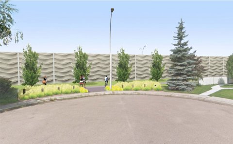
sketch of wall in cul-de-sac


I think what Chaz might be referring to re: bench/planters for this section, is that it's appropriate (and a nice touch) for the new SUP.
That is a long and very narrow swath of land that has never been utilized before and will connect many neighborhoods & to more amenity-diverse areas.
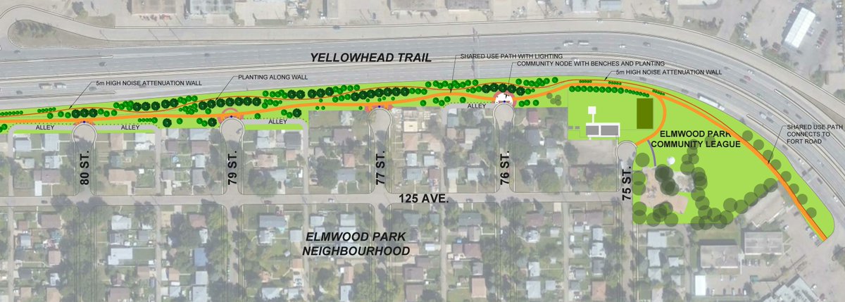
The SUP will have lighting (much needed) and these little community nodes situated at the end of each culdesac with benches/planters within its curve. I don't think there would be any room (or a need) for much else.
The plus is now you can connect easily to all the amenity-rich stuff a block or 3 down the path - there are community gardens, child's playground/splash park, courts, picnic area, open field, etc just to the east at Elmwood Park Community Leauge.
 
Respectfully, Kevin, I disagree -- the node that on the plan says "community node with planters and benches" is (without benefit of an actual scale) as large as a residential lot when comparing spaces in plan-view. I agree with you on the more constrained nodes (but there is not even mention of planters and benches there) which seems to represent the rendering that you use to underscore your point. Planting along the wall is just fine especially along a path. The larger node, however, should be an activity zone that benefits the neighborhood. The City generally falls back to passive uses for park spaces when the urban trend suggests that these kinds of spaces promote drug transactions and other nefarious goings-on. Gabriel might have looked more closely at possibilities is all -- we have got to stop giving the City Planners a pass when they go to their less-than-mindful "planters and benches" mode.
 
I still wish that the gaps I highlighted in my map could be filled as well. This project will add a lot of vital infrastructure for active transportation users, and they're so close to completing the entire corridor. If I recall correctly, part of the alley needs to be left as-is since there isn't enough room to add a multi-use path. I wonder why they're leaving the other gaps (the sidewalk and neighbourhood in the middle).
 
Last edited:
I would love some sort of dedicated pedestrian/cyclist bridge that crosses over the Yellowhead and the railyard, somewhere between 97 St and 82 St. Feels like a shame to do all this work, but the Pedestrian crossings at 82 and 97 are still sort of - terrifying.
Yup, the Yellowhead and CN rail is a huge barrier to active transportation. I've biked across both the 97 and 82 Street intersections and I agree that they are sketchy at best on bike or foot.
 

Back
Top