News   GLOBAL  |  Apr 02, 2020
 9.7K     0 
News   GLOBAL  |  Apr 01, 2020
 41K     0 
News   GLOBAL  |  Apr 01, 2020
 5.5K     0 

January 15th: Here's a snowy view of Lawrence Park for a snowy day - the intersection of Lawrence and Yonge in 1947, looking from approximately 150 feet west of Yonge. The Locke Library on the south east corner isn't there yet - does anyone have more details on it?
s0372_ss0058_it1723.jpg
 
The Locke Library on the south east corner isn't there yet - does anyone have more details on it?


Though it looks like they *may* be prepping the site (is that a trailer? and what's the sign on top of it?

Anyway...

http://www.torontopubliclibrary.ca/branch-detail.jsp?Entt=RDMLIB060&R=LIB060&eT=4

1944 Toronto City Council approved a recommendation by the Parks Committee that a portion of Lawrence Park, at the south-east corner of Lawrence and Yonge Street, with a frontage of 165 feet on Yonge Street and having the required depth, be deeded to the Toronto Public Library as a site for a new branch public library (TPL Board, Buildings & Finance, 7 September 1944). TPL Board given a capital grant of $ 125,000 by the City of Toronto for construction and equipment of a new library in the northern part of the city.

1949 George H. Locke Memorial Branch opened 5 January, Beck & Eadie, Architects. Named to commemorate George H. Locke (1870-1937), Toronto Public Library's chief librarian, 1908-1937.
 

and the second on Avenue Road looking north from Yorkville:


On one hand, widening the street basically wiped out everything you see in that picture. On the other hand, I really like that stretch of Avenue Road today; it feels like a proper entrance to a big city.

York Blvd. in Hamilton received the same demolition treatment but instead of becoming a midrise boulevard it just became a highway through some fields.
 
Thanks for the library details, adma, and Hipster Duck, I know what you mean about that stretch of Avenue Road...

January 16th: In 1933 Teddington Park there is a photo from the crest of the Hogg's Hollow ravine on Yonge Street, with a view of the North Toronto market and streetcar station:
s0071_it9596.jpg


Then in 1934 there are two photos of a Fort York restoration - Block House No. 2:
f1231_it0803.jpg


and the Officers quarters:
f1231_it0802.jpg


Details on all these photos on the Jan 16th historic Toronto photos page.
 
January 17th: A busy day of photos from 1914 through 1938. Starting with some winter fun in 1914 - tobogganing in Riverdale Park, along Broadview on a Saturday:
s0372_ss0052_it0245.jpg


Then by total coincidence, we have a photo of the major operating room on the 4th floor of East Toronto General hospital in 1929:
s0372_ss0001_it0891.jpg


Then in 1935 we are just north of the Royal Ontario Museum and a sketch of a proposed widening of the Alexandra Gates that stood at Avenue Road and Bloor (before moving to the top of Philosopher's Walk):
s1188_fl0001_it0022b.jpg


Finally, in 1938 we have a couple of photos of the snow - Dupont St west of Christie in the Annex:
f1231_it1514.jpg


and then Mount Pleasant at Broadway Avenue in North Toronto:
s0372_ss0058_it1478.jpg


Details on all these photos available at the neighbourhood links above, or on the Jan 17th Historic Toronto photos page.
 
I just happen to have the

1904, SHEET METAL BUILDING MATERIALS CATALOGUE "A". from this Company.

440 pages of drawings + pics + a letter dated 1913 to a customer!


Regards,
J T
 
I just happen to have the

1904, SHEET METAL BUILDING MATERIALS CATALOGUE "A". from this Company.

440 pages of drawings + pics + a letter dated 1913 to a customer!

Amazing how time turns the mundane into art!

January 21st: Not surprisingly, Some of the oldest records related to Toronto aren't photos, but sketches. The Toronto Public Library has a collection of sketches of Henry Langley designed churches, including this Parliament Street Methodist Church, which had its dedication service on the January 21, 1872 in Regent Park
94_primitive_meth_parliament.jpg


Old City Hall has had its problems, as evidenced by this 1921 photo of the decaying stonework, looking down over the south-west corner of Bay and Queen:
s0372_ss0001_it0372.jpg


Details on these two items on the January 21st Historic Toronto photos page
 
January 23rd: Two photos from the corner of Christie Street and Davenport, at tree clearing on the hill in 1914, I assume when they were building the houses along Braemore Gardens on the north east corner, just east of Hillcrest Park in Davenport. First, looking north, up the hill:
f1231_it2209.jpg


And then looking south, down the hill:
f1231_it2208.jpg


(Details on these two photos available on the Jan 23rd Historic Toronto photos page.)
 
The man standing with Lord Halifax (to His left) is Major J E Hahn, principal of John Inglis Co.

Regards,
J T
 
Last edited:
The man standing with Lord Halifax (to His left) is Major J E Hahn, principal of John Inglis Co.

Ah, good to know, I've updated the record, thanks!

January 26th: A relatively 'modern' photo today, from 1961, a mere 50 years ago today of King Street west at John during a snow storm - not sure how many 'invalids' were out getting their chairs, trusses, crutches or supports in that storm, from Authors & Cox:
f1257_s1057_it0022.jpg


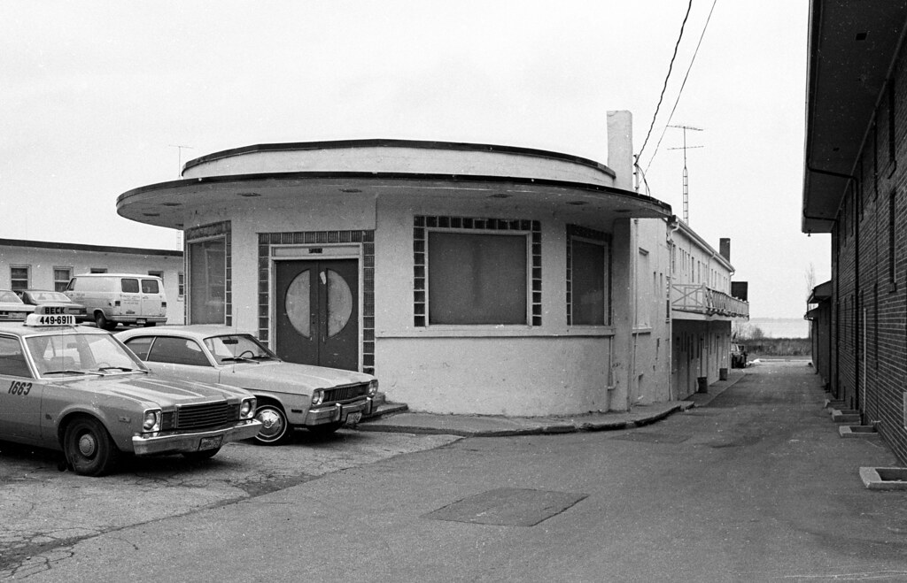
Then in 1983 Collations has an excellent set of photos from along the Lakeshore, including the Palace Motel, at 2083 Lakeshore Blvd W
4293964915_cac22ed4bf_b.jpg


Details on these photos, including the Flickr link to Collations set of photos, is available on, you guessed it, the Jan 26th Historic Toronto Photos page.
 
Jan 18th: There are lots of photos from the corner of Montgomery and Yonge street in North Toronto; here's one from 1932 of the construction of the firehall, which still stands and is used as an active firehall(station 134) to this day:
s0372_ss0001_it1079.jpg

Nice photo of the firehall construction. My dad grew up on St Clements Ave just north of this location. He remembers the building of the firehall and the old no 12 police station a few feet east.
 

Back
Top