News   GLOBAL  |  Apr 02, 2020
 8.6K     0 
News   GLOBAL  |  Apr 01, 2020
 39K     0 
News   GLOBAL  |  Apr 01, 2020
 4.8K     0 

February 7th: A cool picture to start with.... Here is a view of the north end of Dufferin Grove park, looking south from Gladstone Avenue, at the stone gates at the entrance, dated Feb 7th, 1914.
s0372_ss0052_it0301.jpg


The gates are long gone now, unfortunately, and in fact looks more like a photo from Feb 14th the year before, with no gates.... but when I looked closer, I realized that this photo has the gates sketched on - the people in the 1913 photo haven't moved a step in just under a year. Were the gates ever built?

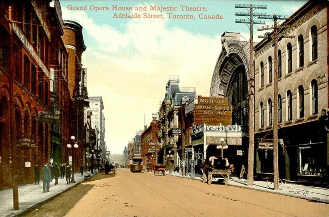
The in 1927 we have a view of Adelaide St, east, from Bay, noon, slow moving truck forced to use "second" traffic lane by parked cars, faster traffic in turn forced over to wrong side of street to pass, (Traffic Study Department)
s0071_it4718.jpg


(Details on these photos available on the February 7th Historic Toronto photos page.)
 
That's the Grand Opera House on the right in that Adelaide picture, right? (Must be one of its last views...)
 
February 7th
Then in 1927 we have a view of Adelaide St, east, from Bay, noon, slow moving truck forced to use "second" traffic lane by parked cars, faster traffic in turn forced over to wrong side of street to pass, (Traffic Study Department)
s0071_it4718.jpg


(Details on these photos available on the February 7th Historic Toronto photos page.)

Similar view in 1907, when the Regent Theatre was the Majestic:

Grand_Opera_House_and_Majestic_Theatre_Adelaide_Street_Toronto_Canada.jpg
 
February 9th: 111 years ago, in 1900, the Don River was full of ice. Here's 'Demolished Eastern Avenue wooden bridge looking north from Grand Trunk Railway bridge':
s0376_fl0002_it0057.jpg


Then a bit farther north we see the river over-flowing to the west side of Riverdale Park. The Necropolis is to the left behind the white fence on the hill, and you can just make out Winchester that ran down into the ravine then up to the Danforth (now the ramp for the DVP).
s0376_fl0002_it0061.jpg


Then exactly 100 years ago today in 1911 we have 'G.T.R. South Parkdale right-of-way looking west across Dunn Avenue to Jameson S. Parkdale Station just west of Close Avenue, on north temp. track (for grade separation) on north side'. There are a bunch of photos from this location over the years.
f1231_it1021.jpg


(For details on these photos see the February 9th Historic Photos page.)
 
February 12th: Two photos from Yonge Street today, back in 1917. The first from Hillsdale, just south of Eglinton, looking north, in Chaplin Estates:
f1231_it1712.jpg


Then farther north on Yonge Street, to Bedford Park. On the left is the fence around Knockaloe Estate (also known as the Ellis Estate? Or is that just around High Park?)
f1231_it0474.jpg


Here's a photo of the gates from a few years later, around 1920:
f1244_it0308.jpg


Details on the 1st two photos on the February 12th Historic Toronto Photos page, with details on the gate photo on the Bedford Park historic photos page.
 
February 14th: Lots of historic photos today; we'll start way back in 1890 of the fire at University College - while the photos are from the next day or days after, I figure +/- a day or two after 121 years is close enough. First, two photos from the City of Toronto Archives:
f1568_it0338.jpg


f1478_it0037.jpg


Then a couple of photos from the U. of T. Archives (which I've never used here... still figuring out their crazy long URLs). Here's University College - Interior of East Wing (Library) after the fire of 1890:
2003-37-2f.jpg


And then another view, University of Toronto Museum, view after the fire in University College:
2004-30-27f.jpg


I'll try and get-tag and date them and add them to the first two on the February 14th Historic Toronto photos page.

(I'll be back later to add more Feb 14th photos.)
 
Less disastrous photos now, starting with 1913, and the Rosedale Ravine looking north from Roxborough Street Bridge:
s0372_ss0052_it0001.jpg


And the older steps to the east of Casa Loma - Spadina Road Park looking north from Davenport Road:
s0372_ss0052_it0004.jpg


Then two photos from Dufferin Grove - kids on a walk in the park:
s0372_ss0052_it0002.jpg


And then the photo of the north end of the park, for the photo we saw a while back, this time with no gate drawn in:
s0372_ss0052_it0003.jpg


Finally, in 1914, we have Trinity Park showing "Gore Vale" in right background:
f1231_it0005.jpg
 
February 17th: Four photos today from the Feb 17th Historic Toronto Photos page, all from the City of Toronto Archives, starting with this rather cinematic photo of the corner of Shuter and Church Street in 1922 in the Garden District. The garbage on the street is surprising, and the fact that everyone has their back to the camera makes for an interesting photo.
s0372_ss0058_it0978.jpg


Then in North Toronto of the same year we have an empty lot at Redpath and Erskine (which remains a parkette to this day):
s0372_ss0058_it0981.jpg


Then we move to 1929 and a busy view of Saturday '3:50 p.m., traffic, on Yonge St, looking south, from Wilton Square, note long lines of parked cars, (Traffic Study Department)'
s0071_it7435.jpg


Finally back uptown, to Davisville Village in 1945 and a view of looking west up the hill on Eglinton Ave E from Hoyle Ave, just west of Bayview:
s0372_ss0058_it1670.jpg
 
February 18th: Two photos today from the February 18th Historic Toronto Photos page, just a year apart. The first, from The Junction, of a a very empty, cold view of the Keele and Humberside Park (now Baird Park) in 1913, although there are lots of foot-prints:
s0372_ss0052_it0014.jpg


The a year later to the day in 1914, we go back to Davenport and a view of the progress at Christie Street north from Davenport Road:
f1231_it1730.jpg
 
February 20th: A wide range of Historic Toronto photos from Feb 20th for today, starting way back over 100 years ago in 1904, of Queen Street west of Lee Avenue in the Beach and the KEW Beach Grocery:
s0376_fl0004_it0035.jpg


Then in 1932 we have a shot of the southwest corner of Hillsdale and Bayview Avenue in Davisville Village:
s0372_ss0058_it1299.jpg


The Parks Department was thinking ahead to the summer back in 1935, and putting together a suggested colour scheme for the Clarke Beach lavatory building down at Cherry Beach:
s1188_fl0001_it0020.jpg


And finally, in Brockton Village we have a view of the iron fence outside church on the southeast corner Brock and Atkin Avenue in 1939:
s0372_ss0058_it1514.jpg
 
February 21st: Two photos today from the City of Toronto Archives of pre-subway construction work back in 1974 on the Historic Toronto photos from Feb 21st page. First, Parcel 2220, 274-278 Dupont Street next to Modern Laundry (which is still there today):
f1257_s1057_it8351.jpg


Then a side view of the same corner and the Bank of Nova Scotia that was torn down for the subway entrance:
f1257_s1057_it8349.jpg
 

Back
Top