News   GLOBAL  |  Apr 02, 2020
 8.6K     0 
News   GLOBAL  |  Apr 01, 2020
 39K     0 
News   GLOBAL  |  Apr 01, 2020
 4.8K     0 

That sure looks like the Broadview Hotel, as J T Cunningham says. The view could only be from the southwest. As JT mentions, there was a Wm Davies plant in this area - lower Don River, west side. The area has been totally cleared for years now in preparation for new housing.


Wm Davies plant picture below.


cypresswasnsrunningsfromeasternimmedwofdonriver.jpg


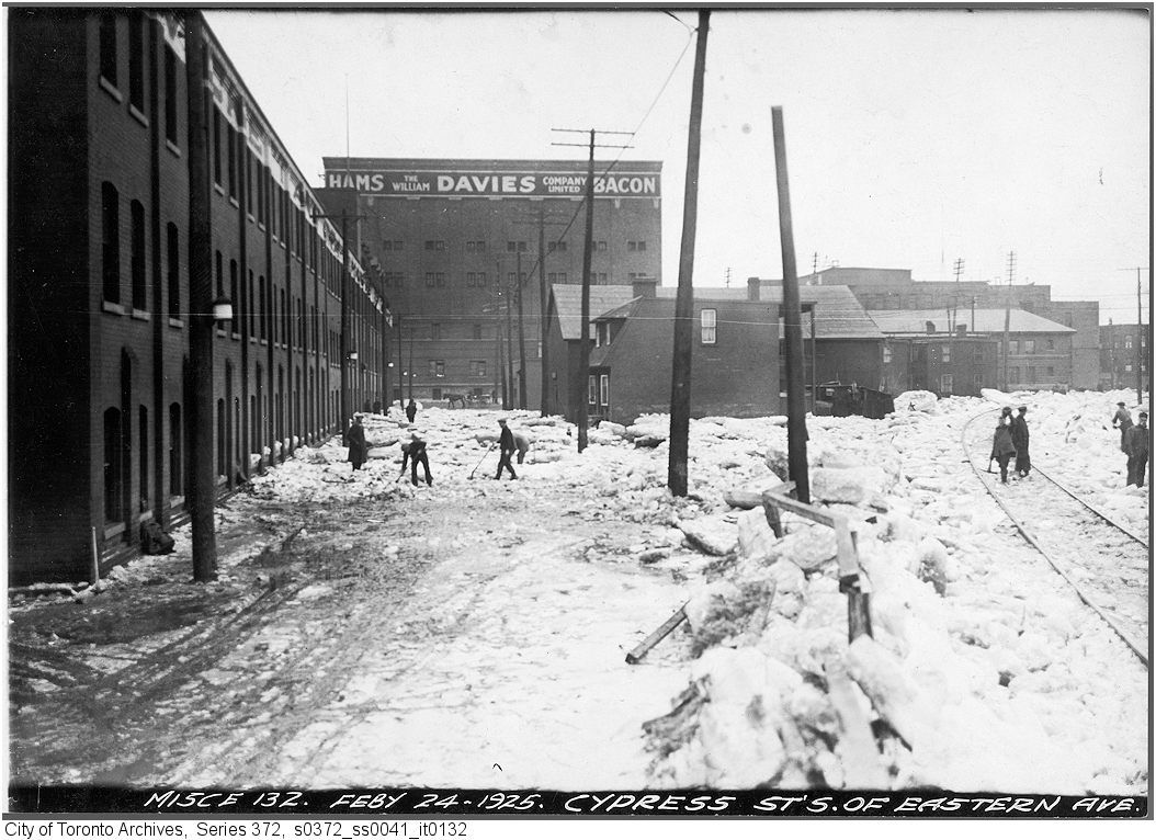
Here is a link to a 1916 map so you can "place" the above view. Map quadrant M 16: Cypress street was a north/south street that ran south from Eastern immediately west of the Don River.

http://maps.chass.utoronto.ca/cgi-bin/files.pl?idnum=1088&title=+1916


I have an upcoming Then and Now of this Wm Davies plant. The picture is in a camera that isn't here at home tonite. I'll fetch the camera, move up the posting date and post it tomorrow. Very timely of BeeRich to bring this up.
 
Last edited:
"Description: Local transit map of Toronto (ON) featuring street car lines (in red), streets, proposed streets & harbour construction, ward boundaries," QUOTE.


The above supplied map certainly does make use of it's descripton re: "streets, proposed streets & harbour construction", as with it's term "proposed".

(LOL)

Eg: Mimico to the West and Fisherman's Island/Simcoe Park Beach to the East.


Regards,
J T
 
Don't get me started on Japanese mustard now!

Yummm!

Reghhhards,
J T
 
Ironically when you posted, I was at Prohibition, 2 doors West of The Broadview Hotel. Also, I was talking about this thread, etc. Mere meters from the focus.

The Eastern Ave bridge is still there, but us Leslievillains know that everything west of the River and South of Queen/King is gone. I've had that map since I started reviewing this thread, but I was told it isn't accurate. In fact, that map is plain strange. I know the Don was straightened. Great map though.

Cheers

UPDATE: I was just told the William Davies plant was near Front & Lower Sherbourne. That far over.
 
Last edited:
Ironically when you posted, I was at Prohibition, 2 doors West of The Broadview Hotel. Also, I was talking about this thread, etc. Mere meters from the focus.

The Eastern Ave bridge is still there, but us Leslievillains know that everything west of the River and South of Queen/King is gone. I've had that map since I started reviewing this thread, but I was told it isn't accurate. In fact, that map is plain strange. I know the Don was straightened. Great map though.

Cheers

UPDATE: I was just told the William Davies plant was near Front & Lower Sherbourne. That far over.

Other links:

http://www.ourroots.ca/e/page.aspx?id=177576

http://en.wikipedia.org/wiki/William_Davies_Company
 
Last edited:
Also I forgot to mention. The distillery district also had breweries. All had spent grains which go to cattle and hogs. I should know this as I'm a brewer. I heard there were penstocks south of the rail lands by the Lever plant. And we come full circle with the same picture.

Well done. Much fun was had.
 
The Eastern Ave bridge is still there, but us Leslievillains know that everything west of the River and South of Queen/King is gone.

Your comment reminded me of the industrialization of that area 56 years ago:

WestDonLandsc1955.jpg
 
"Your comment reminded me of the industrialization of that area 56 years ago:" QUOTE Prof Goldie.


The above pic is to the North & West.

I take it that we are looking at a fire in the area.


Regards,
J T
 
Wow, super picture. And that building north on Sumach. I don't remember that. And no Gardiner.
 
"And that building north on Sumach." QUOTE BeeRich.


What building are you referencing; if it is the tall round structure, that is a

Consumer's Gas storage tank which rose & retreated from below ground

due to it's filling. (manufactured coal gas)


Regards,
J T
 
Consumers' Gas Co. storage tank

Ya looks like a short version of the TD Towers. Black.

Here's another view of the same "gas tank" - before becoming fully extended (1926-27 photo).
 

Attachments

  • aerial6_1927.jpg
    aerial6_1927.jpg
    101 KB · Views: 243
There were others, namely w/s Bathurst Street at Front.

I believe the above to be a "satelite operation", for the west end of town.

Regards,
J T
 

Back
Top