News   GLOBAL  |  Apr 02, 2020
 9.4K     0 
News   GLOBAL  |  Apr 01, 2020
 40K     0 
News   GLOBAL  |  Apr 01, 2020
 5.3K     0 

I haven't found anywhere its working yet.
try here -- google street view, leaside jail

you should see two old houses, on the east side of laird drive, at markham -- the one on the left was the original leaside jail

there are 4 street views available -- sept 2007, apr 2009, aug 2011, and apr 2012 -- click on the red NEW in the box at the top left

the 2012 view shows the houses gone, and the start of construction of the new hyundai dealership, opened in august 2013

hyundai.jpg


p.s. there's an even better example just south on laird, the old locomotive shed repurposed as a longo's --
https://www.google.ca/maps/@43.7060...ata=!3m4!1e1!3m2!1spIsdTIwdqGiKUPUTmFRz7A!2e0
 

Attachments

  • hyundai.jpg
    hyundai.jpg
    84.5 KB · Views: 1,053
Last edited:
try here -- google street view, leaside jail

you should see two old houses, on the east side of laird drive, at markham -- the one on the left was the original leaside jail

there are 4 street views available -- sept 2007, apr 2009, aug 2011, and apr 2012 -- click on the red NEW in the box at the top left

the 2012 view shows the houses gone, and the start of construction of the new hyundai dealership, opened in august 2013


Hmm weird, I see the old image, and can search the address and get the new image, but I can't find any options to cycle through the years.
 
www.cermc.webs.com

The downloadable file is near the bottom of the cover page. You must have Google Earth already installed on your computer to view the map. Any portion of the map can also be uploaded to your mobile GPS unit for use in the field if it runs the .kml/.kmz file format, and most do.

Current systems such as the TTC streetcars are marked in yellow, abandoned routes and historical systems are marked in amber. Where available, photos have been added to station/stop markers, and to the rail routes themselves. Just left click a mark/marker and the photos will load. In some cases where I have had time, you will find a camera icon. A double click on those icons will display the photos from the photographers point of view. Text information is included with each mark to inform you of the system you are looking at, and some systems like the Halifax street railway and the St. John street railway, all the marks are fully cited.
This work is offered for free and I make nothing off of the site traffic, so this is truely a labour of love. I spent all of last summer visiting every streetcar city across Canada doing research for this project and have not fully updated the map with this new information. If you are interested in following the updates as they happen, please take out a free membership on the website and you will receive notices when new updates are available.
I also live for criticism, so please feel free to let me know if you see something missing or incorrect.

Thank you Mustapha for this opportunity to share with everyone.

I also have links to my other projects for the class 1 railways in Ontario and Quebec at the bottom of the home page.

Paul

ShonTron's link to that Pathe video reminds me of FAW's post in this thread a little over a year ago. I haven't had time to surf through his resource; but am looking forward to seeing how much of these old routes now run through peoples living rooms. :)


Historical picture links for those of you on lunch hour.

New York City archives:
http://nycma.lunaimaging.com/luna/servlet


1939. England in Colour.

http://www.dpreview.com/news/2014/0...tm_medium=sidebar-block-Homepage&ref=features


Finnish Wartime Photographic Archive.

http://sa-kuva.fi/webneologineng.html


Camera that saw The Great War.

http://petapixel.com/2014/04/30/camera-saw-great-war/
 
Last edited:
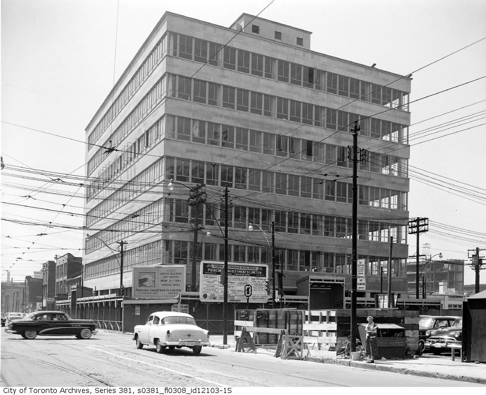
Then. 1954-ish. SW corner of Richmond and York.

12361954ishyorkrichmondswcorner_zps579117cc.jpg


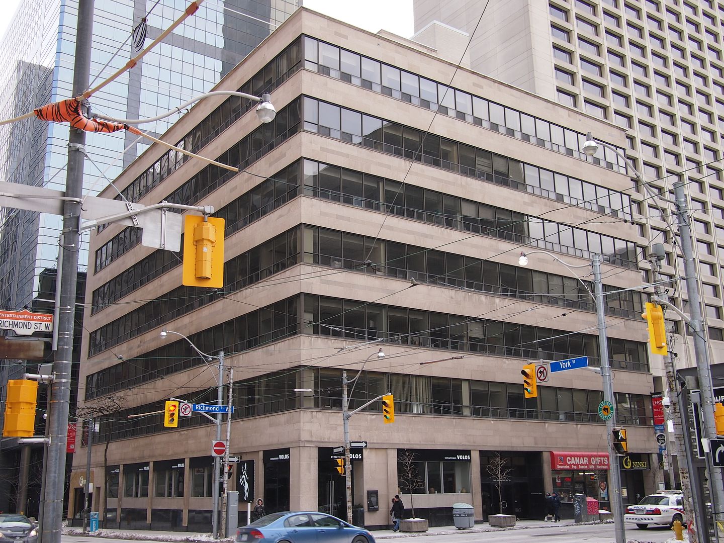
Now. March 2014. A nice old Mid Century building hiding in plain sight.

1237_zpsb79d1f1b.jpg


And, on the opposite SE corner - well, one parcel to the east, of Richmond and York:


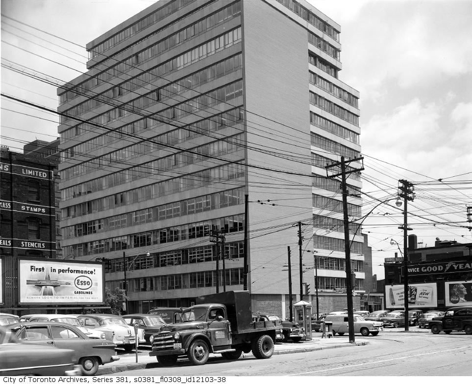
Then. 1954ish again.

12381954ishYorkRichmondBuildingonthesoutheastcornerofYorkandRichmondstreets_zps7ab51de7.jpg


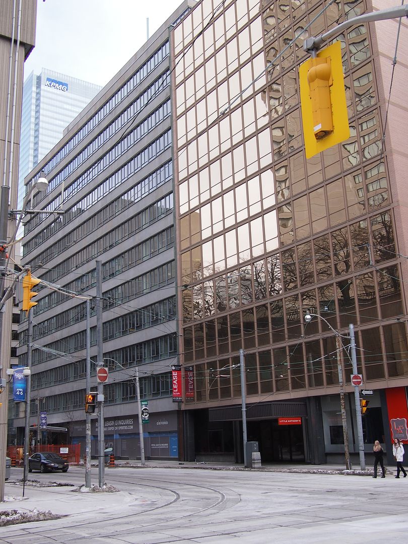
Now. March 2014.

1239_zpsfc3525ab.jpg
 
ShonTron's link to that Pathe video reminds me of FAW's post in this thread a little over a year ago. I haven't had time to surf through his resource; but am looking forward to seeing how much of these old routes now run through peoples living rooms. :)

I am looking forward to your looking through it, but I have recently run across some very accurate maps of London Ontario and am doing an update release in about a week. I will update the electrics map first due to London having previously been my poorest map, then redo the class 1 railways map next. For those interested in London: http://www.lib.uwo.ca/files/madgic/geodetic1926/geo1926index.html

Paul
 
Yonge, south of the CPR tracks, 1916 (in the distance are the steeples of the Primitive Methodist Church at Yonge & Davenport and the Yorkville Town Hall at Yonge & Yorkville):

yongeprice1919.jpg


2014:

yongescrivener2014.jpg
 

Attachments

  • yongeprice1919.jpg
    yongeprice1919.jpg
    99.9 KB · Views: 1,096
  • yongescrivener2014.jpg
    yongescrivener2014.jpg
    94.6 KB · Views: 1,075
Last edited:
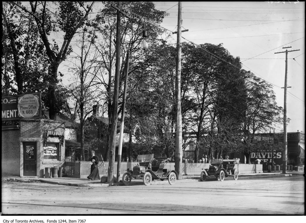
Yonge, south of the CPR tracks, 1908:


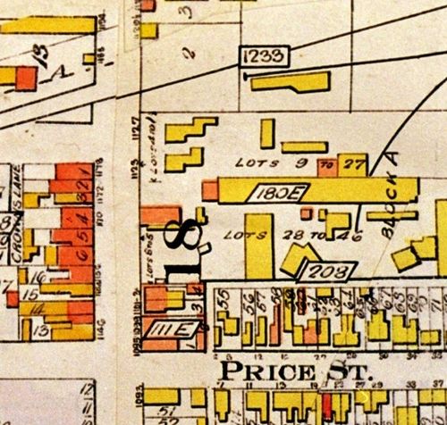
Goad atlas 1913:


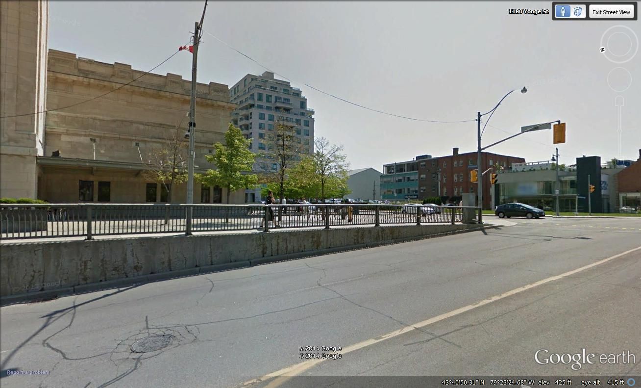
2014:


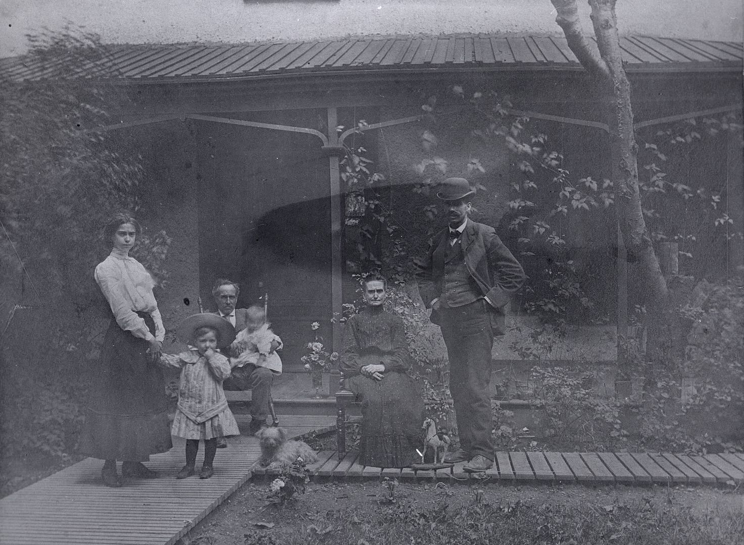
There's a 1904 pic of the northerly house in the TPL collection, which was known as the Martin House:


Caption: Shows, l. to r.: Florence Martin, Edward William Martin (son of William Edward Martin), Edward Martin, Arthur Gordon Martin, Jemima Martin (Mrs Edward Martin), William Edward Martin (son of Edward Martin).

And, in 1916:

 
Last edited:
Yonge, south of the CPR tracks, 1908:

wow, i had heard there was a gravestone place just south of the tracks, but i hadn't realized just how close it was to the tracks, if those are the CP tracks in the foreground of this picture

that's my favourite LCBO, by the way -- see 4:20 at Shaftesbury

i often cross the street to the west side there, go up onto the tracks (it's wide open), and crack a brewski before heading home east along the tracks

i will often alternately go along shaftsbury before getting onto the tracks, my destination being carstowe road and thus into leaside
 
Last edited:
Yonge, south of the CPR tracks, 1908:

There's a 1904 pic of the northerly house in the TPL collection, which was known as the Martin House:


Caption: Shows, l. to r.: Florence Martin, Edward William Martin (son of William Edward Martin), Edward Martin, Arthur Gordon Martin, Jemima Martin (Mrs Edward Martin), William Edward Martin (son of Edward Martin).

I love that photo and attempted to extract more detail:

martinhouse-x_zpsc8c00a42.jpg
 

Back
Top