News   GLOBAL  |  Apr 02, 2020
 8.8K     0 
News   GLOBAL  |  Apr 01, 2020
 40K     0 
News   GLOBAL  |  Apr 01, 2020
 5K     0 

That said, the TTC's own travel time figures for the surface section are terrible. And they haven't even started construction, so they can only get worse. I just can't fathom why (Well, I can but I don't like it) the TTC steadfastly refuses to look at any other cities as a model of how to run proper light rail. I'm not even talking about Europe here. Calgary is a perfectly good model of how to run light rail in a suburban corridor like Eglinton.
Ditto Edmonton. Their south LRT is being built much like Calgary's 202 line. There's no reason that Eglinton East couldn't be designed like that, except with low level platforms.

cal-lrt-marlboroughstn-crowd-median-expwy-trf-20040511_jon-bell.jpg
 
There is a fair amount of stuff east of Brentcliffe (apt. buildings and houses on the north side and townhouses on the south). However, it's not at street level and much of it is hidden by trees.

Image
Hmm, I checked a couple though. Mount Pleasant to Bayview is about 1,100 metres and Bayview to Brentcliffe is 1,400 metres! I'm surprised there isn't at least one at Laird!
So, I redid some measurements on Google Maps.

From Bayview to Laird, it's roughly 1.04 km.
From Bayview to Brentcliffe, it's roughly 1.45 km.
From Leslie to Laird it's roughly 1.26 km.
From Leslie to Brentcliffe, it's roughly 0.84 km.

So, I agree... It does make me wonder why they chose Brentcliffe instead of Laird. Looking at the map, it seems both Laird and Brentcliffe have sufficient space for entrances.
 
They probably selected Brentcliffe because that reduces the length of the cut and cover section compared with Laird. Not necessarily the best solution from a transportation perspective, but making the construction phase a bit less disruptive.
 
Increase in Density

They probably selected Brentcliffe because that reduces the length of the cut and cover section compared with Laird. Not necessarily the best solution from a transportation perspective, but making the construction phase a bit less disruptive.

To construct a station including the associated storage tracks, crossovers and portal to the underground in this part of the alignment, excavation would be required. This is referred to as "cut-&-cover".
Yes, the length of the cut and cover segment is reduced if the station is at Brentcliffe but not a by much. The storage tracks beyond the station shift with the station when moving. The portal will also shift.

At the first PIC in 2008, stations were shown at Laird and Brentcliffe. This was undertaken on a purely transportation planning level. Now at the engineering level, the technical requirements combined with the topography allow for only 1 station between Laird and the West Don River.

Laird and Brentclffe Stations cannot fit. It is physically impossible to fit them.
You would be walking from one platform onto the next.

Although Laird makes sense as it is a major intersection and existing retail starts at that intersection going east and south, Brentcliffe was chosen because of the proposed density increase east of Brentcliffe. Currently there are no density proposals for Laird nor retail intensification.

Furthermore, topography plays a role. It is much easier for the new developments to access Brentcliffe Station entrances at the crest of the hill then to be walking down steep slopes to Leslie.
The same is true existing residencial areas east of Brencliffe.
 
Last edited:
Rollercoaster

Who doesn't love rollercoasters? We can turn Eglinton East into San Francisco lite.

The topography along Elginton is like a rollercoaster. Don't simply look at a Google map. Remember....Toronto has lots of north-south ravines.
The shallower you are...the easier the access from the street but then the more of a rollercoaster ride you'll get and it will be very uncomfortable. The deeper the alignment...the further you are from the street but the ride is more flatter and comfortable.

As for the cut & cover aspect...with 12 to 16 stations and special trackwork areas along Elginton, each requiring cut-&-cover.....this will be a major cluster f*** in the centre of the city. Major inconvenience to everyone, from exisitng transit users aong Elginton to businesses to pedestrians to residences (not being able to access their homes). Each location will be a 1-2 year ordeal. No major city is doing this anymore. Business is too important to disrupt nto to mention impacting buildings that are located so close to the street.....alternative entrances or access will need to be designed for each location.

So to avoid all of this roller-coastering and surface impact, the TTC is studying the a single bore tunnel. This is one of the panels in the construction methodology of the presentation.
 
Placing the stop at Brentwood rather than Laird seems like a calculated decision to serve the incredibly underused land which is located wholly east of Laird and perhaps reduce development pressures on the residential neighbourhoods.
 
Currently, the following buses terminate at the Eglinton HRT station at Eglinton and Yonge:

5 Avenue Road
32 Eglinton West
34 Eglinton East
51 Leslie
54 Lawrence East
56 Leaside
61 Avenue Road North
100 Flemingdon Park
103 Mt. Pleasant North


The 97 Yonge passes the Eglinton station, but does not terminate there.

Rebuilding the Eglinton terminal is not needed with the Eglinton Crosstown LRT. The 5 Avenue Road and 61 Avenue Road North could be combined, and the 74 Mt. Pleasant and 103 Mt. Pleasant North could be combined, with transfers at Avenue Road and Mt. Pleasant stations as they pass them. The rest could terminate at Eglinton stations more closer to their main routes.

The money for rebuilding the Eglinton bus terminal can then be used for the new streetcars. If done right, the TTC could redevelop the bus terminal lands as office space for rental income.
 
Even if there's a couple of buses left, it can be quite a simple structure ... more like Coxwell or St. George. Probably peanuts compared to what they are going to spend at Eglinton station building the Eglinton RT line.
 
Not sure about any plans for new bus loops/terminals, but Leaside could start/end from the Brentcliffe/Laird station, Leslie and Lawrence East from Leslie, and Flemingdon Park from Don Mills. They're not going to keep running all of these routes out of Eglinton Station, are they?

The 5 Avenue Road and 61 Avenue Road North could be combined, and the 74 Mt. Pleasant and 103 Mt. Pleasant North could be combined
I can see Mt. Pleasant as one route. The 5 Avenue Road runs up Oriole Parkway to Eglinton so it might be kept it as a separate route.
 
I can see Mt. Pleasant as one route. The 5 Avenue Road runs up Oriole Parkway to Eglinton so it might be kept it as a separate route.

Oriole Parkway is two streets over from Avenue Road. It would be no big deal to combine the routes by putting a short 200m jog along Eglinton.
 
Even if there's a couple of buses left, it can be quite a simple structure ... more like Coxwell or St. George. Probably peanuts compared to what they are going to spend at Eglinton station building the Eglinton RT line.

I could see the 74 and 103 combined. Neither are very busy routes, but 5 and 61 do have different service patterns. Not sure what to do about the 56 and 51. The 56 should probably go to Eglinton Station and provide skeletal surface service.

From what I saw, Keele (with 3 bays) and Don Mills (with 5-6 bays) would have the only off-street loops. I can definitely see the 100 and maybe the 54 and 51 looping at Don Mills, Keele looks like it would host a Trethewey bus. (There might be a loop for 47B,C at "Caledonia" station as it is a bit of a walk to the namesake street.)

The route will add some transferring for a lot of people, so I hope the underground service is as reliable as it should be.
 
picture.php


Left turns would re-routed off Eglinton and onto the side street. Apparently, they are used elsewhere in the world. See this link from Wikipedia, where it is called a Michigan left. Other synonyms are: median U-turn, median U-turn crossover, or boulevard turnaround.

Michigan_lefts.jpg


MichiganLeftSigns.png


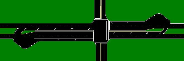
Michigan lefts occur at intersections where at least one road is a divided highway or boulevard. Left turns onto—and sometimes from—the divided highway are prohibited. In almost every case, the divided highway is multi-laned in both directions.

When on the secondary road, drivers are directed to turn right. Within a 1/4 mile (400 m), they queue into a designated U-turn (or cross-over) lane in the median. When traffic clears they complete the U-turn and go back through the intersection. For additional safety purposes, the U-turn lane is designed so traffic only flows through it one-way.

Similarly, traffic on the divided highway cannot turn left at an intersection with a cross street. Instead, drivers are instructed to overshoot the intersection, go through the U-turn lane, come back to the intersection from the opposite direction and turn right.

When vehicles enter the cross-over lineup, unless markings on the ground indicate two turning lanes in the cross-over, drivers are to line up single file. A cross-over with two lanes is usually designated at high volume cross-overs, or when the right most lane is proceeding forward to an intersecting street. In this case, the right most lane is reserved for vehicles completing the Michigan Left. Most cross overs must be made large enough for semi-trailer trucks to complete the cross over. This large cross-over area often leads to two vehicles incorrectly lining up at a single cross-over.

MI_Left_on_narrow_blvd.JPG


In Toronto's version, there would be no direct left turns from a divided roadway on Eglinton and the secondary street will have the U-turn.
 
Last edited:
I didn't know there was a name for that. I already do that to avoid some of the more aggravating lefts in the city (tho U-turns are sometimes questionable depending when/where you pull them).
 

Back
Top