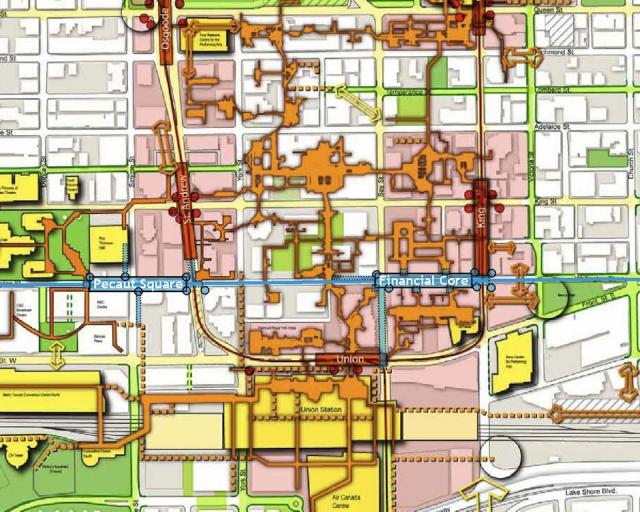
For City Hall Station, we're likely going to see this situation.

Relief Line Stations in red, Yonge Line in yellow, pedestrian paths in black. Tunnels aren't shown.

ZTA6hqi.png


I suspect it won't be directly at City Hall. The west end of the station will be on Bay Street, the east end on Yonge Street. The transfer from Yonge to Relief Line would be a very short walk (maybe 30 meters) and the walk to Nathan Phillips Square/City Hall would be 75 meters or less. This would also allow for a direct connection to the Eaton Centre, which is the main destination in the area, as well as the Bay and the Sheraton Centre. It would connect to the Financial District via PATH. University Station would be built just west of Osgoode Station, with the east end of the Relief Line station connecting to the west side of Osgoode Station.

This makes a lot more sense than plunking the station in the middle of Nathan Phillips Square. That setup would require a 250 meter transfer between the Relief Line and Yonge, and the Relief Line and University Line, nearly twice the length of the Spadina Station transfer, and wouldn't connect directly to the Eaton Centre, which is the biggest attraction in the area.

The setup in my map also avoids the pesky problem of building an interchange station under the most used subway line in North America, in the middle of a busy downtown core with tall buildings around.
 
From my limited perspective, Queen has always seemed slightly more practical than King or a more southerly alignment.

1.) The rail corridor will see a substantial increase in rail traffic. It would make sense to locate any new rapid transit slightly farther away from that to improve coverage.

2.) King is more amenable to a transit mall than Queen.

3.) The subsurface environment around Queen always seemed more forgiving. The concentration of >50storey buildings along King between Yonge and Spadina seem like bad news for a tunnel.

4.) Queen would do a better job of serving low income communities. (it would be a grim reflection on lopsided political power if the recent yuppie migrants to King East leapfrogged the longstanding communities around Regent Park and Moss Park for rapid transit access).

5.) Queen has the potential to be a shorter route. Broadview-NPS would be a kilometre shorter than Pape-St. Andrew. That could easily be a few hundred million, plus added travel time (relief potential).

6.) Transferring with the YUS along Queen just seems easier than on King. I don't know how exactly the interchanges on Queen would be designed but anything would be easier than building under King and St Andrew.

The one big downside to Queen, IMO, is the lack of connection to Unilever. We all know that employment density is what drives transit ridership. Then again, Toronto isn't London or Paris where there is a shortage of suitable office space in the core/along Queen, so it shouldn't be too hard to just shift office space elsewhere. Lord knows a multi-billion dollar regional transit project shouldn't be skewed for the benefit of a private land owner.
 
For the Queen alignment, a must is a new connection from Queen to the Financial District, without travelling through The Bay shopping centre. The current setup (below) isn't very pedestrian friendly. Plus, The Bay's management probably doesn't want tens of thousands of commuters rushing through the store.

Just cut/cover a new PATH connection right under Bay Street. Or at the very least, widen the sidewalks on Bay between Queen and King and do something to eliminate the wind tunnel there.

urbantoronto-7322-24944.jpg
 
I stick by the idea of running the east-west portion of DRL under Richmond and Adelaide (one tunnel under each street, with stations under north-south cross streets). Building under these streets also means we don't have to dig underneath subway stations on the Yonge-U line. I'd suggest having pedestrian transfers (through PATH if suitable) to BOTH Osgoode and St. Andrew stations, and further east, to BOTH Queen and King stations. This would reduce crowding on any of these stations' platforms. Leave the Queen and King streetcars intact. We'll need them in the core. New York has duplicate lines along busy routes. Also, I'm not advocating for expressways by suggesting combining the tunneling for DRL with the tunneling for an expressway. I'm suggesting a cost effective way of burying the Gardiner and opening up more land for pedestrians and cyclists where the elevated Gardiner currently exists. Hard to disguise my contempt for some of the stupid remarks on here...Can people actually look at the directions of roads, the spaces beneath them, and the bigger picture for long-term city planning?
 
Last edited:
I think Queen is ideal because it's more central to more of downtown than King is. While the financial district is the highest concentration of jobs, there are many thousands of jobs north of there. The map below is from the city's employment survey and illustrates why a Queen route works so well - it's right smack in the middle of all the jobs. It's central to not only the financial district, but also Ryerson, Queen's Park, College Park, the hospitals, UofT, and the Eaton Centre. In other words, most of downtown.
8WA-LOFPQU6lhmmR_ySdEyw2vbo-MW9MR4Zw30BmMfXK16mEqZha_ECG5MaduZmVEmuoBQ3V_zC6r9ZSofYN_Sp7yo-OjmwZtvbWssXnCRLFZ6UA66Ff650bS3-mTO5X227lp9DqhbS-qzEKNEUF9ywvNPRauwYWVZ77mi36WA1GUPhY3mE0Y-1o8EamxWUEpGAIOoRvVUF-plutED3xjvnjJLCN7lbdvRhM905tYmyDDEo3S2esSLJmyNGduU7Vs4QH4lKuEH65YeFe_YLdkyBRUtJfh8LLCeGSoCj0yqFKXRe3I6smyxm4KJ7-DuinNPFOQosC-5-LGGNZUcaSB8aRDzMcctKAckAZzHr9jgiL556Jblv8mAUd5MrQ9X1MRr8h4bp1RkmotIBFgHRkV4J2j9-lzC-4qzgBZFELMLbeEeDxdyV6MgCSmkp_a6nCtcVHIloizu4r4nWBCSwNab4E2SzEu3wq4Ygg4ONKMY-lvlROJw4Ot2plSue1wGCKAwwVV8l8mGK6UYYP7ry5bSTcWnstAn6Te0snTlGel98CnGf3rtru71R_kXFUgPb25AQv=w409-h419-no


Hopefully the King Street transit mall happens as well. I could see a Queen subway and a King streetcar mall coexisting happily.
 
There should be a separate City Hall station from Queen station, not only for better crowd control but to get bypass the Bay store when walking south.
 
There should be a separate City Hall station from Queen station, not only for better crowd control but to get bypass the Bay store when walking south.

You don't need another station, just another exit. Your point is valid though. The station will likely be deep enough that you can have a concourse level above the platform level that runs from the Queen Station concourse to Bay. This could connect the lower level of the Eaton Centre with City Hall and a future PATH connection under Bay St.
 
With the Old City Hall being re-purposed, they could use the basement as new PATH connections. Even part of the building could become an entrance.

58881_original.jpg
 
Assuming it will be at Bay St and called "City Hall" station. Wonder what will happen to the connections with Osgoode and Queen Station.
A 200 metre subway platform would extend pretty much from Bay (north of Queen) to York. That leaves about 150 metres in the west to University and 250 metres in the east to Yonge.

So perhaps centre the platform between Yonge and University from Bay (south of Queen) to near Osgoode Lane, with escalators upwards from the platform, you need about a 150 metre walkway under Queen at each end to reach the existing and Queen stations.

Presumably you connect these walkways with a walkway over the station, and then connect that as necessary into adjacent buildings (Eatons Centre, Bay, City Hall parking lot, Victory Building, etc.

Extending the subway another stop to Spadina would be a good idea.

But I suppose this means no more Queen Streetcar.
The 501 is over 24 km long. We are talking about less than 3 km of subway along Queen.

They need 600 metres of it to run the 504 from Broadview to King. I doubt those coming from the west, have any desire to get off at the new station and walk to Yonge. That leaves a 2-km gap from King to Yonge along Queen.

At the same time they'd need a long construction detour for the 501. Perhaps we'll finally see some usable track on Richmond and/or Adelaide from York to Church!

And needless to say this new station will receive the Spanish treatment.
Probably depends on how much width is available, by the time you stay away from the existing foundations.
 
Last edited:
First, the Nordheimer Ravine is actually a very short section of Castle Frank Brook between St. Clair West station and Spadina Road.

Second, whatever route the Relief Line would take, the station interchanging with a station on Yonge needs la solución española.
 
Can someone explain to me how the announcement of the preferred alignment of the RL changes in any way the probability that we will see this line up and running within the next 20 (more?) years?

Isn't this just more of the same "lines on a Fantasy map" that we have seen for decades and decades by various iterations of Toronto municipal government?

With the attention it has received over the past two weeks, I would say it's alive and well in the minds of staff and Council.

The problem is money. Once we've advanced Crosstown, TYSSE, extended Line 2 to Scarboro, and built Malvern LRT, plus RER, plus Smarttrack, not to mention implementing the Gardiner plan.....the civic piggy bank will be just about drained. Other priorities will be competing for federal and provincial funds: health care won't be cheaper in five-ten years, with the boomers that much older. First Nations are winning court cases that will lead to much money being spent there.

The risk is that transit will only be seen as a priority for so long. It will be a challenge to continue to stress the urgency of this line.

- Paul
 
This is an environmental assessment, which as far as I know, has never been done for the line before. When the current work is done, it can move towards construction. Having an environmental assessment means it's basic design, it's the next step up from lines on a map.
 

Back
Top