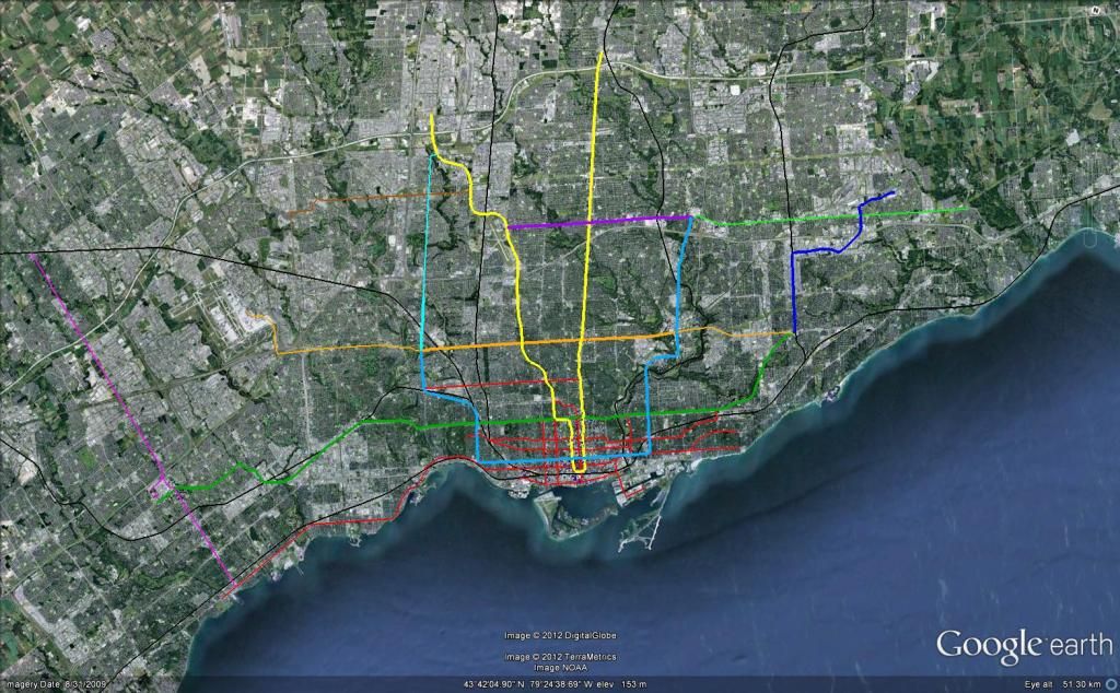
My new official vision for Toronto transit:
LIST OF PROJECTS:
SUBWAYS
DRL
Yonge extension
Sheppard west subway
Subway to MCC
LRT
Eglinton Crosstown
Sheppard East LRT
Finch West LRT
Jane LRT
SRT extension & replacement
Hurontario LRT
STREETCARS
Bay Streetcar
Lakeshore extension to Port Credit
St. Clair extension
Waterfront East Streetcar
Portlands Streetcar
King street ROW
DRL
The DRL (To be renamed the Queen line) would be constructed in 5 phases, in quick succession. The Queen line is the centrepiece of this entire vision.
phase one would be the Downtown east section, running from spadina to Bloor. Phase two would be the Eglinton East section running from Bloor+Pape to Eglinton+Don Mills. phase 3 would be the Downtown West section, running from spadina to Bloor and Dundas. Phase 4 would be the Sheppard section, Running from Eglinton to Sheppard. Finally, phase 5 would Run from Bloor and Dundas to Jane and Eglinton.
The Queen streetcar line directly above the subway would be shut down, and all service currently using it would be directed to the new King street ROW.
COST: $13 billion dollars
LENGTH: 30km
YONGE EXTENSION
The yonge extension would be built as planned to Richmond Hill Centre.
COST: $3.2 billion dollars
LENGTH: 7km
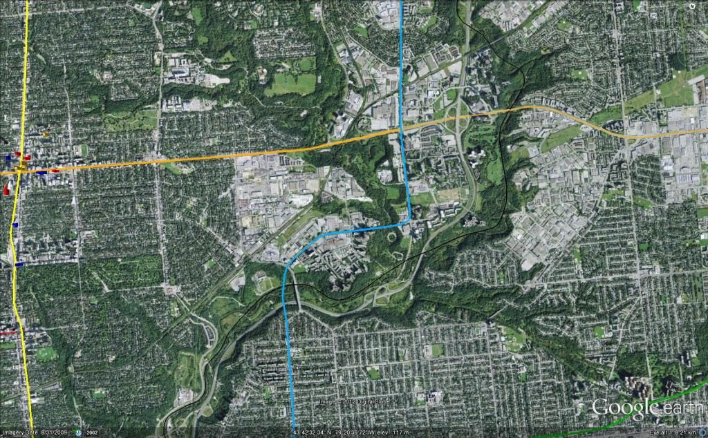
SHEPPARD WEST SUBWAY
The Sheppard west subway would be built to Downsview station. it would actually only contain 3.5km of new tunnels as 800m of the extension is already built.
COST: $1.2 billion dollars
LENGTH: 3.4km (4.2km total travel distance)
SUBWAY TO MCC
The Extension of the Bloor Line to MCC would provide a vital subway link the the largest suburban city centre. The extension would be built in 2 phases, with phase one being to Sherway Gardens, and phase two being built to Mississauga city centre.
COST: $3.8 billion dollars
LENGTH: 11.8km
EGLINTON CROSSTOWN
The Crosstown would be built as planned with an extension to the airport with one exception. The aboveground portion of the line between Don Mills and Laird would be grade separated in some form, to allow seamless access to the new Queen line.
COST: $7.8 billion dollars
LENGTH: 30km
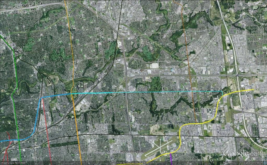
SHEPPARD EAST LRT
The SELRT would be built as planned, but with the extension to malvern past Sheppard being elevated.
COST: $1.8 billion dollars
LENGTH: 14.5km
FINCH WEST LRT
To be built as planned.
COST: $1.2 billion dollars
LENGTH: 10km
JANE LRT
Would be built aboveground From Steeles west Subway station to just below the 400, where it would travel to Eglinton underground. Passengers wishing to travel further south would transfer to the Queen line.
COST: $1.8 billion dollars
LENGTH: 10.7km
SRT EXTENSION AND REPLACEMENT
To be constructed as planned with the extension to Malvern Town Centre.
COST: $2.5 billion dollars
LENGTH: 11.6km
HURONTARIO LRT
To be constructed as planned.
COST: $2.2 billion dollars
LENGTH: 23km
BAY STREETCAR
This "new" line (really replacing a line that was ripped up 50 years ago) would run from a reconfigured union station stop underground to Queen street, with a single stop on king + Bay. from Queen it would emerge from a portal to travel up bay to Dupont station, without a ROW.
COST: $380 million dollars
LENGTH: 4.8km
LAKESHORE EXTENSION TO PORT CREDIT
A simple extension to Port Credit, With a ROW where one is feasible.
COST: $300 million dollars
LENGTH: 6km
ST. CLAIR EXTENSION
An Extension of the St. Clair line to The new Queen subway line at Jane street. will feature a ROW.
COST: $80 million dollars
LENGTH: 1.7km
WATERFRONT EAST STREETCAR
To be built as planned.
COST: $270 million dollars
LENGTH: 2.6km
PORTLANDS STREETCAR
To run up cherry and turn on to Unwin ave. for a short distance, ending at the Hearn Generating plant to serve some sort of new major attraction built inside of it. Will feature a ROW.
COST: $125 million dollars
LENGTH: 2.5km
KING STREET ROW
The King street Streetcar would be rebuilt in a ROW from King + Queen to Queen + King + Roncesvalles. Car lanes would be reduced to a single lane in each direction, and all Streetcar lines that once served on Queen would travel on this ROW.
COST: $400 million dollars
LENGTH: 7.9km (no new revenue service, therefor will not be included in final "new services length" tally)
FINAL TALLYS
New Revenue Service Length
SUBWAY: 53km
LRT: 93.5km
STREETCAR: 17.6km
TOTAL: 164.1km
COST
TOTAL: 40.775 billion dollars
SUBTRACTING ALREADY FUNDED AMOUNTS: 32.275 billion dollars