


doady
Senior Member
GIMP and Paint.NET are raster editors. For making maps, I suggest a program that is vector-based, like Illustrator instead of Photoshop.
|
|
|
GIMP and Paint.NET are raster editors. For making maps, I suggest a program that is vector-based, like Illustrator instead of Photoshop.
Yes, Ortelius is vector. Quick search turns up some other possible good programs to use for maps:
http://www.onextrapixel.com/2011/03/15/10-best-alternatives-to-adobe-illustrator/
They list GIMP, but as they say, it isn't a vector-based graphics editor.


Still haven't quite figured out the pdf uploading, but here is a link to the map hosted on dropbox:
I tried that, but Google really butchers the quality of the image, so I redid it. It should work now, sorry!If you have GMail, you can upload it to Google Docs and make it public I believe (though I could be wrong).
Still haven't quite figured out the pdf uploading, but here is a link to the map hosted on dropbox:
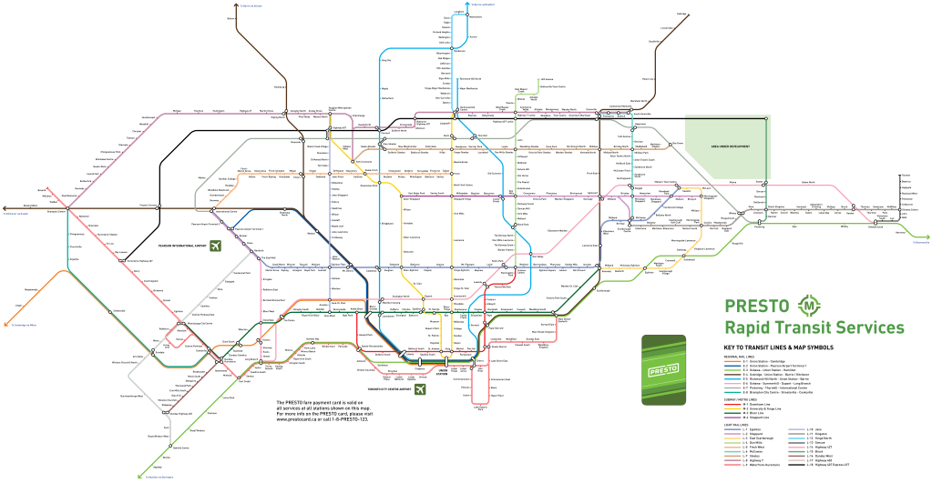
EDIT: Since dropbox link flopped, I tried Imgur again and it turned out a lot better: http://i.imgur.com/nwSXQ.jpg
Anyways, I've just went all out and rapid transit-ifyed nearly every possible corridor in the GTA in this map.
I've based it on Metrolinx's Big Move and bielawski's map that was posted here a couple of months ago: http://urbantoronto.ca/forum/showth...ing-fantasy-maps)/page122?p=636193#post636193 , where I've made use of nearly all of the rail corridors.
It was partially inspired by London's Oyster Rail Network map: http://www.tfl.gov.uk/assets/downloads/oyster-rail-services-map.pdf , both in the graphic style and in the matter that it is a whole regional transit network accessible with one fare card.
Some feedback and criticism is greatly appreciated!

