News   GLOBAL  |  Apr 02, 2020
 8.5K     0 
News   GLOBAL  |  Apr 01, 2020
 39K     0 
News   GLOBAL  |  Apr 01, 2020
 4.8K     0 

The DRAFT WESTERN WATERFRONT MASTER PLAN presented on February 19th is available in PDF at this link: http://www.toronto.ca/waterfront/pdf/public_meeting_and_cag_final.pdf
picture.php

It includes:
THE 10 BIG MOVES
  1. Realign Lake Shore Boulevard (Humber River to Ontario Place)
  2. Re-establish beaches
  3. Provide for more swimming (+ protected flatwater)
  4. Reinforce + create new recreational nodes
  5. Build better East-West connections
  6. Improve + create new North-South connections
  7. Improve + provide new signalized intersections on Lake Shore Boulevard
  8. Accommodate Waterfront West LRT alignments
  9. Push parking out of the Park
  10. Plant trees + naturalize.

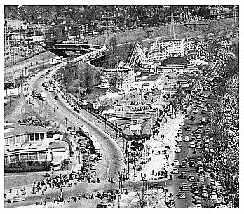
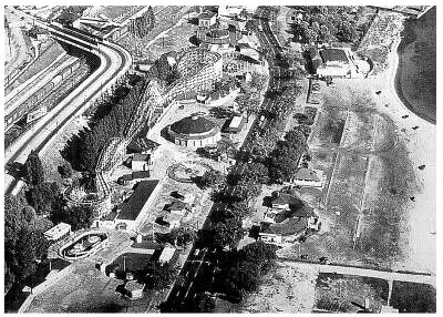
Some detail I found interesting are: the closing of Dowling and replacing with a new pedestrian signal crossing, pedestrianize Colborne Lodge Road, Lake Shore Blvd. realigned to allow for more park to the south not just at Sunnyside but at Jameson, parking at beach area on north side of Lake Shore Blvd., new pedestrian bridge at Wilson Park , replacement 20 m wide Roncesvalles pedestrian bridge (the width of Queen Street), and more. See the PDF for the rest.
 
Last edited:
Very good plan. The re-alignment of Lake Shore Blvd is interesting. They should plan for a bus loop and the bottom on Jameson Blvd so they can extend the 47 Lansdowne bus from Queen. I don't think a streetcar ROW in the middle of Lake Shore is a very good idea.
 
I think some infill to build out the shore would be a good idea as the Gardiner runs very close to the lake here.
 
Regardless of the price tag, I think that in order to revert this part of the waterfront to its former vitality, the Gardiner must be decked over.

It's been talked about in Parkdale a lot lately but I haven't seen any serious proposals.
 
The closest to decking over the Gardiner would at Jameson.
picture.php

But I think they'll still keep it open.
 
Wow, surprisingly good stuff suggested in the plan. Re-aligning Lakeshore would be a big move forward alone.
 
Decking over the Gardiner in this spot would be really great. I do really like that the new pedestrian bridge is going to be as wide as a street. That should be sweet!
 
The Roncesvalles bridge they have planned seems to almost have the same configuration as the original Sunnyside bridge. The original bridge was torn down for the "improvement" of traffic into downtown Toronto (ie. Gardiner Expressway).

This photo shows the original Sunnyside bridge being built:
fo1231%5Cf1231_it1224.jpg


This photo shows it after it was built. The Sacred Heart Orphanage building seen to the left has been replaced by the St. Joseph's Health Centre:
fo1231%5Cf1231_it1713.jpg


View of the bridge from the water:
fo1231%5Cf1231_it1882.jpg


View of the bridge after landfilling:
fo1231%5Cf1231_it1641.jpg


View of the bridge as Lake Shore Road is being built:
fo1244%5Cf1244_it1466.jpg


Closeup of the bridge supports:
ser71%5Cs0071_it9194.jpg


Sunnyside bridge during the amusement park days (you can barely make out the hydro towers):
Air1949a.jpg


Sunnyside bridge during a quieter time:
Air1949b.jpg


The new 20 m wide Roncesvalles pedestrian bridge will be longer than the Sunnyside bridge, but maybe not as long as the current narrow pedestrian bridge, if Lake Shore Blvd. is pushed north.
 
Last edited:
I think it's a very sensible plan and would go a long way to connecting the west end to the lake.
Humber bay park on the western edge of the plan is a very busy spot on nice days now but it so much quieter as you travel east past the Humber River.
Improving access down Windermere and Ellis will surely make it a more lively spot.
 
Two roads will be closed to vehicle traffic: Dowling Avenue and Colborne Lodge Road.

picture.php


However, there is accommodation for a Western Waterfront Light Rail Transit alignment.
Need for a Queen/Roncesvalles connection is key to future decision-making – i.e.,
• If connection necessary (which it appears to be), then we propose that the Streetcar cross the railway to the North at or before Dowling – in order to avoid a new bridge across Gardiner and Railway
• If connection not necessary, then we propose that the Streetcar stay in the LSB median as far as Colborne Lodge.​
They call it "Streetcar" when it should be called "Light Rail Vehicle" or "LRV".

picture.php
 
Last edited:
It appears that this plan is one that is doable in every way, with nothing innovative or visionary. I lament the loss of restructured breakwaters/offshore islands, offshore trails, Humber outflow deflection, race course extension, etc. I realize that these can be implemented at any time in the future but since this is supposed to be a long term plan they should have been included.
 
A little fantasy, not really related to this plan but kind of. But would it be desirable in any way to bring back the old plans of building something across Humber Bay, perhaps an iconic bridge of sorts? I think it would look pretty nice... but of course I haven't taken any cost-benefit analyses into consideration.
 
A little fantasy, not really related to this plan but kind of. But would it be desirable in any way to bring back the old plans of building something across Humber Bay, perhaps an iconic bridge of sorts? I think it would look pretty nice... but of course I haven't taken any cost-benefit analyses into consideration.

When was the last time you visited Toronto?

 
^ that's a very beautiful picture of the footbridge, but by Humber Bay I meant the actual "bay" (say, from around Humber Bay Park to just off the Ex grounds), not across the mouth of the river, which is technically not on the bay.
 

Back
Top