News   GLOBAL  |  Apr 02, 2020
 8.4K     0 
News   GLOBAL  |  Apr 01, 2020
 39K     0 
News   GLOBAL  |  Apr 01, 2020
 4.7K     0 

or, we can find a private developer that will shoulder part or all of the cost, when the money/time comes

In exchange for what? Right to build on parkland? Considering the cost of such a project, the concessions must be rather significant indeed. I can see s. 37 funds used for portions the WWF plan, but I don't see anything as dramatic as a new bridge funded that way.

AoD
 
In exchange for what? Right to build on parkland? Considering the cost of such a project, the concessions must be rather significant indeed. I can see s. 37 funds used for portions the WWF plan, but I don't see anything as dramatic as a new bridge funded that way.

AoD
Right to build on various parcels in the city? Developmental rights in the Portlands? Decking over the rail corridor? Operating the bridge and charging toll for it?

Let's say they charge $2 per vehicle. The traffic through that part of the Gardiner is now around 100k a day, so assume that variation in daily traffic pattern compares to 250 days a year of max traffic (a fairly modest estimate), so in a year the toll revenue would be $50M. Assuming a cost of $500M, it could be recovered in as little as 10 years in this "minimal scenario". And that's not taking into account the potential revenue from running trains and transit on the bridge and assuming no increase in traffic. Given a 50- or even just 25-year operation right, the deal could be quite attractive.

There are many ways by which the financing can be done as long as we (including the gov't and the private sector) are willing, creative and flexible enough, but without the prospects of this ever coming to fruition, discussing the financial arrangements here in any more details would be moot. And as I said I have no intention to dabble in the BOT controversies. So moving on...
 
I would love to see this fantasy bridge built because it truly would allow the city to reconnect with the western waterfront again, but as others have already said, unfortunately there are far more pressing priorities. The fact remains that a highway never should have been built here in the first place, and it will probably be up to the citizens of Toronto in the 22nd century to fix it.
 
I know, lets build a toll road/bridge with public funds and then sell it to a private company... oh wait, that's already been done:D

revenons a nos moutons... I like the plan overall and the beaches will look lovely but... Does anybody here actually use Toronto-area beaches to lay in the sand and swim in the water?? With all the gull and goose poop it doesn't seem very attractive to me. Is there a reasonable way to control the water fowl?
 
Tewder:

Well actually the BOT he is referring to is the private sector building and operating the bridge, and transferring it back to the public after a set number of years (not incidentally when lifecycle costs starts creeping up). 407 is the opposite - publically funded and operated before being sold to the private sector.

re: swimming

That's why they are planning to "enclose" the stretch of waters - the WW is consistently the section of the waterfront that is closed most often due to e. coli from wet weather runoffs. I don't see why it can't happen again, considering there was swimming in the area historically.

AoD
 
From The Star of Wednesday, February 25, 2009:

...councillors last night approved spending $1 million for an enclosed curtain to deflect dirty water at Sunnyside beach.

This Beach Curtain “pilot project†including pump ($1.0M) is to assess success of the curtain. If it is successful, the curtaint will be expanded further as the first part of the Western Waterfront Master Plan. See page 67 of the draft.

Now with dogs being banned from the beach, this will mean cleaner sand for the geese. At least the dogs would have tried to chase the geese away, but now the owners could get ticketed if they do.
 
The closest to decking over the Gardiner would at Jameson.
picture.php

But I think they'll still keep it open.

As a comparison to the above map, the following map shows the area in 1914 before Lake Shore Blvd., before the Gardiner Expressway, and before the expansion of the railway. The area to the west of the Exhibition was residential. You can see Jameson and Dunn extending down to the lake over the level railway crossings.

fo1231%5Cf1231_it0064.jpg


BTW. The area to the east of the grandstand was New Fort York or Stanley Barracks (as opposed to the currently existing Old Fort York) of which only one building remains.
 
I like the part of the plan making a bridge connecting Roncesvalles to Lake Shore, but I don't know why they don't make it a vehicular crossing as well as pedestrian.
 
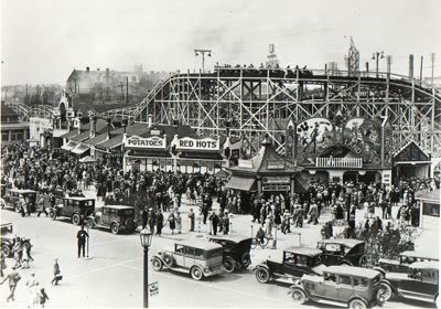
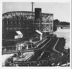
I'd like to see a return of the rollercoaster. I think that would add some character to the beach :)
 
I'm curious whether the Exhibition featured a midway back in those days when there were a few permanent ones already nearby. I guess it was likely truer to an actual agricultural fair back then?
 
One priority should be to devise a solution so that the bollards can be eliminated on the Martin Goodman trail. We have so few long and useful trails for cycling in the city, and the bollards compromise what should be the best one.
 
this may not be a good question.

But what the heck is realigning the Lakeshore is supposed to mean?
 
this may not be a good question.

But what the heck is realigning the Lakeshore is supposed to mean?

Right now the Lakeshore (or specifically Lakeshore blvd) is split by roughly 300 feet of grass/median/parking/whatever. Realigning it means bringing the Eastbound lanes up north a little bit so that it runs right beside the Westbound lanes and allows that park/greenspace to become part of the lakefront.
 

Back
Top