|
|
|


You are using an out of date browser. It may not display this or other websites correctly.
You should upgrade or use an alternative browser.
You should upgrade or use an alternative browser.
- Thread starter Mustapha
- Start date
")
Mustapha
Senior Member
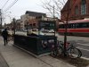
An interesting shot I saw posted on another group a couple of days ago. Which city are you in?
(it's a film set)
View attachment 39434
I'm game:
It's obviously Toronto; standing in as New York?
And,... the film set is SUITS; just another guess. I've seen their sets around Toronto and seen their props.
bAuHaUs
Active Member
...and I guess the garbage can is just floating there.
the lemur
Senior Member
I'm game:
It's obviously Toronto; standing in as New York?
And,... the film set is SUITS; just another guess. I've seen their sets around Toronto and seen their props.
I walked past that the other day. One of set crew said it was something called Beauty and the Beast? Maybe I misheard. Anyway, there was also a NYC-style newsstand and a pretzel cart.
There is no such station on the 4 or 5, FWIW, and there was a fake street sign nearby saying Eastin with an i, for some reason.
junctionist
Senior Member
Suits takes passing off Toronto as New York to the edge of what's acceptable. They film throughout the Financial District and surrounding areas on occasion without blurring the background or changing any streetscape features beyond the newspaper boxes and taxis. The streets are clearly the streets of Toronto with our distinctive street lights. You can even see streetcar tracks in street scenes. They show panned shots of Scotia Plaza and the Bay-Adelaide Centre as the exterior of the New York office building where the law firm in the show is supposedly located.
They pass off the Canada-Life Building as just another New York landmark. In a 30 second scene that's actually set in Toronto, they had to blur the background at King and Simcoe--they must have been concerned that it would confuse some people watching the show.
They pass off the Canada-Life Building as just another New York landmark. In a 30 second scene that's actually set in Toronto, they had to blur the background at King and Simcoe--they must have been concerned that it would confuse some people watching the show.
AlbertHWagstaff
Senior Member
adma
Superstar
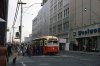
That woman in the fur on the left of the '77 photo is really struttin'
Mario1972
New Member
Mario1972
New Member
An interesting shot I saw posted on another group a couple of days ago. Which city are you in?
(it's a film set)
View attachment 39434
Great catch. Thanks.
Mario
Avangard Photography
r937
Active Member
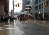
here's an interesting "then and now" all in one shot (well, i thought it was interesting, maybe it's just me)
usually the "then" is an old scene or building, and the "now" is the same view seen today
in this case, the "now" is an old building, and the "then" is what it will look like in the future, at which time the old building will be "then" and the new one "now"
st clair west at poplar plains --

usually the "then" is an old scene or building, and the "now" is the same view seen today
in this case, the "now" is an old building, and the "then" is what it will look like in the future, at which time the old building will be "then" and the new one "now"
st clair west at poplar plains --
Attachments
Koolgreen
Active Member
That woman in the fur on the left of the '77 photo is really struttin'
and is that serge savard behind her?
Mustapha
Senior Member
A 1990s Toronto photo extravaganza
http://www.blogto.com/city/2014/12/a_1990s_toronto_photo_extravaganza/
http://www.blogto.com/city/2014/12/a_1990s_toronto_photo_extravaganza/
Toronto Lad
New Member
Bathurst bridge over CNR (beltline) at Roselawn Ave
I don't think you guys have covered this one here please excuse me if you have...
While looking for pictures of the bridge on Bathurst St just north of St Clair Ave I found these, pictures of the bridge that was once over the CNR tracks (former Beltline Railway) on Bathurst St south of Roselawn Ave which appears to have been torn down and the entire area re-graded, in later 1934.
In this series of pictures the city archives use the Tomsett residence at 2005 Bathurst St (north west corner at Roselawn) as a reference point, note the odd number address on the west side of Bathurst St which today is even numbers, not sure if this switch is common in Toronto.
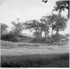
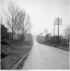
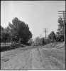
This is the best one of the bridge itself, taken facing south west from Roselawn Ave east of Bathurst.

Another from a south of the tracks east of Bathurst St, still facing south west. (June 1934)

One more facing south east, appears to be during demolition. (June 1934)

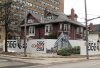
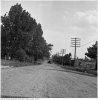
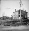
Here's the view south on Bathurst St showing the bridge still in place just prior being torn down, that's Roselawn Ave crossing Bathurst St with a jog as it does today. The Tomsett residence is immediately to the right and you can just make out a gas pump that was on their front lawn, under the tree at the extreme right centre. (June 1934)

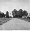
Here's the view east on Roselawn Ave from west of Bathurst St. The Tomsett residence is on the left with the 3 car garage SW of the house, the gas pump is to the left of phone pole hidden by the tree, bridge is to the right just out of the picture.
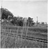
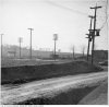
There's a siding north of the tracks on the west side of Bathurst St so the building on the right is probably owned by the railway. (June 1934)

Picture of said siding, the view south east from Roselawn Ave (now Elm Ridge Dr) west of Bathurst St showing the siding north of the tracks and two large houses up on Forest Hill Rd. (June 1934)

Bridge removed and grading under way, looking south Tomsett residence on the right, Forest Hill Rd bridge in the distance.

Looking south on Bathurst St that's the gas pump again on the extreme right now up on a hill, the railway level crossing further south and the bridge on Forest Hill Rd in the distance. (Dec 1934)

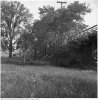
Close up of the Tomsett residence with gas pump / lawn ornament. (Dec 1934)

Looking south west from Roselawn Ave east of Bathurst St after re-grading. (Dec 1934)

Sorry to end on a sad note but while searching for a reason they archivists picked Tomsett residence as a landmark I found this unfortunate bit of history, the death in that house of their 26 year old son, a suicide by hanging, Nov. 1929.

I don't think you guys have covered this one here please excuse me if you have...
While looking for pictures of the bridge on Bathurst St just north of St Clair Ave I found these, pictures of the bridge that was once over the CNR tracks (former Beltline Railway) on Bathurst St south of Roselawn Ave which appears to have been torn down and the entire area re-graded, in later 1934.
In this series of pictures the city archives use the Tomsett residence at 2005 Bathurst St (north west corner at Roselawn) as a reference point, note the odd number address on the west side of Bathurst St which today is even numbers, not sure if this switch is common in Toronto.
This is the best one of the bridge itself, taken facing south west from Roselawn Ave east of Bathurst.
Another from a south of the tracks east of Bathurst St, still facing south west. (June 1934)
One more facing south east, appears to be during demolition. (June 1934)
Here's the view south on Bathurst St showing the bridge still in place just prior being torn down, that's Roselawn Ave crossing Bathurst St with a jog as it does today. The Tomsett residence is immediately to the right and you can just make out a gas pump that was on their front lawn, under the tree at the extreme right centre. (June 1934)
Here's the view east on Roselawn Ave from west of Bathurst St. The Tomsett residence is on the left with the 3 car garage SW of the house, the gas pump is to the left of phone pole hidden by the tree, bridge is to the right just out of the picture.
There's a siding north of the tracks on the west side of Bathurst St so the building on the right is probably owned by the railway. (June 1934)
Picture of said siding, the view south east from Roselawn Ave (now Elm Ridge Dr) west of Bathurst St showing the siding north of the tracks and two large houses up on Forest Hill Rd. (June 1934)
Bridge removed and grading under way, looking south Tomsett residence on the right, Forest Hill Rd bridge in the distance.
Looking south on Bathurst St that's the gas pump again on the extreme right now up on a hill, the railway level crossing further south and the bridge on Forest Hill Rd in the distance. (Dec 1934)
Close up of the Tomsett residence with gas pump / lawn ornament. (Dec 1934)
Looking south west from Roselawn Ave east of Bathurst St after re-grading. (Dec 1934)
Sorry to end on a sad note but while searching for a reason they archivists picked Tomsett residence as a landmark I found this unfortunate bit of history, the death in that house of their 26 year old son, a suicide by hanging, Nov. 1929.
Attachments
-
 f0207_s1251_it0178.jpg192.1 KB · Views: 1,318
 -
 f0207_s1251_it0179.jpg192.4 KB · Views: 1,290
 -
 f0207_s1251_it0177.jpg162.6 KB · Views: 1,307
 -
 f0207_s1251_it0181.jpg178.3 KB · Views: 1,251
 -
 f0207_s1251_it0186.jpg150.8 KB · Views: 1,270
 -
 f0207_s1251_it0349.jpg178.1 KB · Views: 1,288
 -
 f0207_s1251_it0187.jpg134.5 KB · Views: 1,268
 -
 f0207_s1251_it0180.jpg245.8 KB · Views: 1,272
 -
 f0207_s1251_it0182.jpg203.6 KB · Views: 1,279
 -
 f0207_s1251_it0265.jpg181.6 KB · Views: 1,277
 -
 Tomsett.jpg243 KB · Views: 1,509


Last edited:
Anna
Active Member
I think that Mr Tomsett had an issue with the grading. Some of those photos and a few others are titled "In arbitration, Tomsett and Forest Hill" showing various other slopes in the area - maybe to prove he had not lost property value even though it was now very difficult for him to pump gas?
Toronto Lad
New Member
I wonder if it was SOP for the city to take before and after pictures to cover themselves or if they were anticipating an issue in this case?