


afransen
Senior Member
Following Lakeshore W then going to a station on Kitchener Line, while not going a good job of serving local trips doesn't make much sense to me.
|
|
|
Ontario Line West Extension
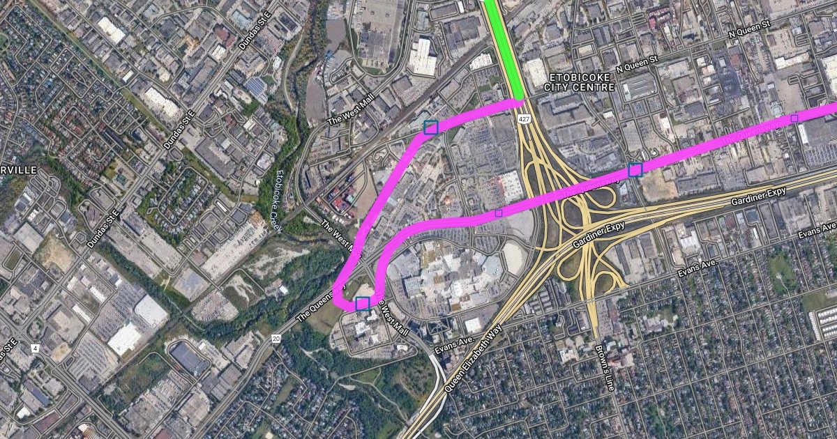
This is my proposal for a western extension of the Ontario Line, including exact routing, rough station locations and explanations for each section of the line. To preface and prevent any confusion, this is set roughly 15+ years in the future and assumes that the Gardiner east of Park Lawn has been capped and eliminated as a highway, with the entire structure east of Exhibition being destroyed. However, west of Exhibition the former Gardiner R.O.W is preserved and used to create a widened GO/OL corridor. Additional tracks are added to allow for future express/branch lines or interlining with any future TTC/GO project.
These three images are a relatively low detail rendition of the full map I created on a separate platform. The link to the full map is below and on it each portion of the line and each station have in depth explanations given for them.
OntarioLineWest
Detailed routing of a potential Ontario Line West extension with stations.www.scribblemaps.com
I hope you find my proposal interesting and I welcome feedback and advice.
The colour key is as follows:
Blue = Expanded GO Lakeshore West Corridor
Green = Highway Median
Pink = Elevated Track
Section 1:
Starting from the current OL terminus at Exhibition, the line runs along the repurposed Gardiner R.O.W until Park Lawn road. The OL will have a connection with the currently under construction Park Lawn GO Station. From here it enters the median of the Gardiner Expressway and runs at grade so as to not conflict with the low bridges over the Gardiner along Royal York and Grand Avenue. There is already a substantial median on this portion of the Gardiner so no major lane reductions (if any at all) would be needed. Arriving at Islington, the line raises off the Gardiner and runs elevated over what is currently the Cineplex parking lot on the south west corner of Islington/Queensway. It then runs elevated down the center of the Queensway. An elevated trackage further east of Islington on the Queensway would not be possible due to the narrowness of the road and existing suburban homes.
View attachment 452952
Section 2:
Continuing elevated along the Queensway, the line has a flyover over the 427/Gardiner interchange. From here it continues elevated along the Queensway until the West mall where it turns south to a station on the north side of the existing medical facility. Thereafter looping north-east, there is an additional station as close to the rail corridor as possible to allow for an easy transfer from the future Line 2 extension to Sherway from Kipling along the rail corridor. Briefly after this the line runs elevated along North Queen Street, then enters the median of highway 427.
View attachment 452953
Section 3:
The final and likely least controversial portion of track continues along the median of the 427, then runs elevated over the interchange of highway 427, 27 and the 401. There is a westwards run towards the eastern terminus of the Mississauga Transitway and future Renforth station of the Eglinton Crosstown Western Extension. Turning north again the route runs elevated again for a short time before entering the median of the 427 before making a western turn onto the ground of Pearson Airport. Here it once again runs elevated to avoid the complex road network below, before finally ending north of the terminal where a new station will be constructed adjacent to the existing building.
View attachment 452954
I think Elevating it on Kipling Avenue similar to what we're doing on Don Mills is definitely feasible given the land use.I looked closely into the following the old Kipling RT plan, but apparently the hydro corridors are no longer available for transit? Something to do with the provincial ministry. The other issue with that route is it misses all the existing and future density in Sherway gardens and along the 427 (west/east mall). I don't think building a whole light metro through deeply suburban central etobicoke is worth the cost.
Devil's advocate: wouldn't more people be using Kitchener line/UP if headed to Pearson? In the context of GO Expansion of course. I like something more like Kipling as it actually serves some communities with poor RT access along the way. It is tricky to design a western OL extension without duplicating existing or in development RT lines.I like the scope of this option: Humber shores, south Etobicoke, and finally Pearson. That means, a better use of the OL capacity west of downtown (with Phase 1 to the Exhibition only, the line will be lightly used in the west). On the other hand, the number of additional boardings should not be so great as to render the relief aspect at the Exhibition disfuctional. The Pearson bound demand should be counterpeak anyway.
Also, like the attempt to avoid tunneling where possible. Not sure about the engineering challenges though.
Don't really like the detour to Sherway Gardens and back. That will increase the cost and slow down the majority of riders. Rather, would rely on local routes to connect Sherway Gardens to the closest OL West station. Or, could split the line just east of the 427 and send one branch to Sherway and the other branch up the 427 to Pearson.
You can try to be a little less intense and angry if you don't agree with someone else's suggestion. Everyone can have their own opinion and it may or may not match with yours. A few days ago, you had an outburst like this when I had proposed a Line 2 extension route as if I had committed a crime. If you don't like the post, just sip a glass of wine and continue scrolling to the next post!The question I am asking is no different than what I have stated in the past for maps, ""HAVE YOU LOOK AT THE AREAS FIRST HAND"" to see what there today????
Do you Think MTO Will allow 2 lanes of traffic for 13+ Months to be remove to allowing for building of the Guideway on 427??
The Same Question for the Gardiner under City of Toronto control Question??
Where on 427 do you think the guideway will be built??
Where do You Think it Will Happen on the Gardiner??
Where In The Rail Corridor do you think you can place the guideway???
What impact will the building of the guideway have on GO Service??
Its so happen I was fixing some of my Flickr tags that I came upond these photos shot in 2012 off Bloor St overpass for 2 developments taking place with one on each side of 427 to help you. Have some shots somewhere for Burnhamthrope, but not going looking for them.
Welcome to the boards. Nice proposal.Ontario Line West Extension
This is my proposal for a western extension of the Ontario Line, including exact routing, rough station locations and explanations for each section of the line. To preface and prevent any confusion, this is set roughly 15+ years in the future and assumes that the Gardiner east of Park Lawn has been capped and eliminated as a highway, with the entire structure east of Exhibition being destroyed. However, west of Exhibition the former Gardiner R.O.W is preserved and used to create a widened GO/OL corridor. Additional tracks are added to allow for future express/branch lines or interlining with any future TTC/GO project.
These three images are a relatively low detail rendition of the full map I created on a separate platform. The link to the full map is below and on it each portion of the line and each station have in depth explanations given for them.
OntarioLineWest
Detailed routing of a potential Ontario Line West extension with stations.www.scribblemaps.com
I hope you find my proposal interesting and I welcome feedback and advice.
The colour key is as follows:
Blue = Expanded GO Lakeshore West Corridor
Green = Highway Median
Pink = Elevated Track
Section 1:
Starting from the current OL terminus at Exhibition, the line runs along the repurposed Gardiner R.O.W until Park Lawn road. The OL will have a connection with the currently under construction Park Lawn GO Station. From here it enters the median of the Gardiner Expressway and runs at grade so as to not conflict with the low bridges over the Gardiner along Royal York and Grand Avenue. There is already a substantial median on this portion of the Gardiner so no major lane reductions (if any at all) would be needed. Arriving at Islington, the line raises off the Gardiner and runs elevated over what is currently the Cineplex parking lot on the south west corner of Islington/Queensway. It then runs elevated down the center of the Queensway. An elevated trackage further east of Islington on the Queensway would not be possible due to the narrowness of the road and existing suburban homes.
View attachment 452952
Section 2:
Continuing elevated along the Queensway, the line has a flyover over the 427/Gardiner interchange. From here it continues elevated along the Queensway until the West mall where it turns south to a station on the north side of the existing medical facility. Thereafter looping north-east, there is an additional station as close to the rail corridor as possible to allow for an easy transfer from the future Line 2 extension to Sherway from Kipling along the rail corridor. Briefly after this the line runs elevated along North Queen Street, then enters the median of highway 427.
View attachment 452953
Section 3:
The final and likely least controversial portion of track continues along the median of the 427, then runs elevated over the interchange of highway 427, 27 and the 401. There is a westwards run towards the eastern terminus of the Mississauga Transitway and future Renforth station of the Eglinton Crosstown Western Extension. Turning north again the route runs elevated again for a short time before entering the median of the 427 before making a western turn onto the ground of Pearson Airport. Here it once again runs elevated to avoid the complex road network below, before finally ending north of the terminal where a new station will be constructed adjacent to the existing building.
View attachment 452954
thank youWelcome to the boards. Nice proposal.
yep, have seen the same thing with that person, seems to be hanging onto the fact they worked with the MTO 20 years ago but doesn't understand there is a reason they are no longer working with the MTO lmaoYou can try to be a little less intense and angry if you don't agree with someone else's suggestion. Everyone can have their own opinion and it may or may not match with yours. A few days ago, you had an outburst like this when I had proposed a Line 2 extension route as if I had committed a crime. If you don't like the post, just sip a glass of wine and continue scrolling to the next post!
Devil's advocate: wouldn't more people be using Kitchener line/UP if headed to Pearson? In the context of GO Expansion of course.
I like something more like Kipling as it actually serves some communities with poor RT access along the way. It is tricky to design a western OL extension without duplicating existing or in development RT lines.
i hadn't thought of that but I think your right, a branch split at the meeting of the 427 and Queensway would open up a lot of possibilities. Allow for faster access to pearson, prevents the awkward routing and opens the possibility for the Sherway branch to extend into Mississauga or maybe even down to long branch GO.I like the scope of this option: Humber shores, south Etobicoke, and finally Pearson. That means, a better use of the OL capacity west of downtown (with Phase 1 to the Exhibition only, the line will be lightly used in the west). On the other hand, the number of additional boardings should not be so great as to render the relief aspect at the Exhibition disfuctional. The Pearson bound demand should be counterpeak anyway.
Also, like the attempt to avoid tunneling where possible. Not sure about the engineering challenges though.
Don't really like the detour to Sherway Gardens and back. That will increase the cost and slow down the majority of riders. Rather, would rely on local routes to connect Sherway Gardens to the closest OL West station. Or, could split the line just east of the 427 and send one branch to Sherway and the other branch up the 427 to Pearson.
Don't really like the detour to Sherway Gardens and back. That will increase the cost and slow down the majority of riders. Rather, would rely on local routes to connect Sherway Gardens to the closest OL West station. Or, could split the line just east of the 427 and send one branch to Sherway and the other branch up the 427 to Pearson.
For the Dufferin option, they can probably do something similar to the Lakeshore East corridor.
Starting from Exhibition:
Dufferin/Queen
Brockton (Dufferin/Dundas)
Dundas West (<> line 2)
"Junction" (Dundas/Dupont)
Stockyard (replaces planned station on Kitchener line)
Mount Dennis (<> line 5)
Jane/Lawrence
Jane/Wilson
Jane/Sheppard
Jane/Finch (<> line 6)
and then might as well, Jane/Steeles, Highway 407 (<> line 1)
Line should be entirely elavated on Jane.
I like this idea a lot, but have some concerns.
I agree the Ontario Line West extension should head north on Dufferin, although I think terminating at Fairbank (Dufferin & Eglinton) probably makes more sense. That would be roughly 7.6 km long from Exhibition. My concern would be that if there's a need to eventually relieve the Ontario Line with another metro line then you've used the two most logical routes on one line (Dufferin & Jane). If a second light metro line is eventually needed Jane is the perfect route for that. Then this future metro line (OL2) would run under King or Wellington or Front through the core.
View attachment 455395