News   GLOBAL  |  Apr 02, 2020
 8.8K     0 
News   GLOBAL  |  Apr 01, 2020
 40K     0 
News   GLOBAL  |  Apr 01, 2020
 5K     0 

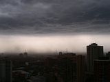
Holy crap it is nuts out there. I have seen strong winds in storms, but I don't think I've seen any that strong in a long time now. Easily over 100 km/h.
 
There was also what looked suspicously like a Water spout on the lake, it then promptly went right over the island airport and kicked up every inch of dirt in the airport and blew it into the inner harbour. Never seen anything like that before. Wouldnt be surprised if the lone q400 sitting out there recieved some damage.
 
From Mississauga, looking towards downtown:

04.25.2009%20-%20Storm%2002%20(Resized).JPG


04.25.2009%20-%20Storm%2001%20(Resized).JPG
 
Pearson had a gust of 115 km/h - which is very likely a new record for april, as the previous high was 111 km/h on April 06 1979.
 
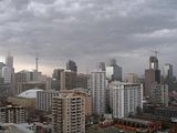
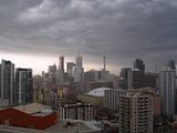
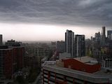
...and the storm as it roars into downtown. Photos from west to east

Click on the thumbnail to enlarge, then click again on the image for full size.

 
Last edited:
Weather summary for all of Southern Ontario and the National Capital
Region issued by Environment Canada Toronto at 2:49 AM EDT Sunday
26 April 2009.

..The first significant severe thunderstorm event of the year hits
Southern Ontario..

-------------------------------------------------------------
==weather event discussion==
A cold front moved across southern and eastern Ontario Saturday
afternoon along with a spate of severe thunderstorms. Most of the
storms were congregated into a line and fueled by the warmest and
most humid air of the season. They hit extreme southwestern Ontario
between 2 and 3 PM then roared northeastwards at speeds of close to
120 km/h at times. They reached the greater Toronto area around 5 PM
and Ottawa between 7 and 7:30 PM. They also affected portions of
cottage country around Georgian Bay and east. Ontario hydro at 9 PM
last evening indicated upwards of 44,000 customers without power
across southern Ontario with the hardest hit swath from Lambton
county northeast across the north of Toronto to Ottawa. That number
was reduced to around 32,000 without power as of 3 AM.

Following is a preliminary summary of wind gusts and some damage
reports received as of 10 PM last evening. There are no new reports.
-------------------------------------------------------------
Date
Time(lcl) location strongest wind gust (km/h)

3:00 PM Sarnia 96
4:21 PM Muskoka 78
4:27 PM Elora 98
4:30 PM Wellington county 102
4:38 PM Guelph 96
4:42 PM Cambridge 100
5:00 PM Lagoon City 80
5:00 PM Orillia 80
5:00 PM Barrie 91
5:05 PM Toronto Pearson airport 115
(strongest wind gust reported since jan 1978)
5:15 PM Markham (Buttonville) 83
5:17 PM Toronto (Hwy 407/bayview) 111-130 (EST)
5:32 PM Toronto city centre arprt 83
6:00 PM St Catharines 78
6:04 PM Peterborough 89
7:38 PM Gatineau 96
7:22 PM Windsor 94

Damage reports:

2:50 PM marble-sized hail south of Parry Sound
3:00 PM power lines and trees down in and around Sarnia
4:00 PM unofficial sighting of funnel cloud in Huron county
4:00 PM power lines and trees down in Waterloo region
4:10 PM some trees down in Strathroy
4:20 PM power lines and trees down from Stratford to Kitchener
4:30 PM some trees down south of Tavistock (se of Stratford)
4:45 PM numerous and trees down and lamp post down in
Wellington county
4:46 PM possible tornado (unofficial sighting) near Woodstock
5:00 PM some trees down near King City
5 - 6 PM several trees down in and around Toronto with sporadic
Power outages
6:40 PM considerable trees and power lines down in Lanark county
7:40 PM considerable damage to houses just north of Gatineau

Please note that this summary contains the observations at the time
of broadcast and does not constitute an official and final report of
the weather events or the high impact events attributed to the
weather events.
 
i was coming home from the doors open event in guelph and got caught in the storm. in some places, the dust was so thick it looked like fog.

n172006360_38067409_1408112.jpg


n172006360_38067411_3618818.jpg


n172006360_38067412_1269015.jpg


n172006360_38067414_1554572.jpg


n172006360_38067416_1456.jpg
 
Weather summary for all of southern Ontario and
The national Capital region
Issued by Environment Canada Toronto at 5:33 PM EDT Monday 27 April
2009.

..The first confirmed tornado of the season for Ontario...

-------------------------------------------------------------
==weather event discussion==

After receiving reports of funnel clouds and a possible tornado in
the Windsor area Saturday evening, an Environment Canada damage
survey team was sent out earlier today. After speaking with some
eyewitnesses to the event and viewing the damage, Environment Canada
is confirming Ontario's first tornado of the 2009 season. The tornado
briefly occurred near the intersection of Hanna st east and langlois
avenue in Windsor. It did minor roof damage to a union hall and
Debris from the roof also did some damage to homes to the southeast
of the union hall. The tornado was rated as a Fujita scale zero event
with maximum winds around 90 kilometres per hour. This is the lowest
rating on the Fujita scale which goes from zero to five.
Environment Canada personnel are continuing to investigate damage
from Saturday's storms that occurred in the Ottawa area. Some of this
damage may also have been related to tornadoes. An update on this
investigation will be issued on Tuesday.
Saturday's storms were a reminder that the summer severe weather
season has now begun in southern Ontario. The season normally begins
in late April and lasts until early October. Severe thunderstorms can
produce large hail, heavy rain, damaging winds or tornadoes. At this
time of year it is always a good idea to stay informed about the
latest weather forecasts, watches and warnings. On days when severe
weather is possible, keep an eye on the sky and be prepared to seek
the most solid shelter available.
 
And another...


Weather summary for all of southern Ontario and
The national Capital region
Issued by Environment Canada Toronto at 2:56 PM EDT Tuesday 28 April
2009.

The second confirmed tornado from saturdays storms over Ontario?.

On Saturday April 25th a line of thunderstorms crossed eastern
Ontario including the national Capital region. Around 7:30 PM the
Ottawa-Gatineau region experienced a brief period of very high
Winds..Gusts as high as 96 km/h were measured at the Gatineau
airport. There were numerous reports of downed trees, power lines
And power outages across the region, and a few buildings lost part
Or all of their roofs, on both sides of the river.

Environment Canada believes that most of the damage from this event
was straight-line wind damage due to the strong outflow from the
thunderstorms. However, there was one swath of damage in the west end
of Ottawa, from brittania park towards carlington heights (total
length approx 5 km) which experienced intermittent significant
damage. The damage path ranged from 50 metres wide over the
Western part of the path to near 150 metres wide over the eastern
part. Furthermore, one eyewitness near the brittania yacht club
reports seeing three waterspouts over the river, one of which headed
towards brittania beach. Other witnesses on morisset ave. Reported
seeing funnel clouds and swirling Debris.

The combination of the damage track and eyewitness reports is
sufficient for Environment Canada to confirm the second tornado of
the season for Ontario. (while three individual waterspouts were seen
over the water, this will be treated as one tornado event.) the
tornado was rated as an upper end Fujita scale zero (f-0) event with
maximum winds around 115 km/h.

The first confirmed tornado of the season occurred Saturday over
Windsor and was rated lower end f-0.
 
Got a question for y'all: Are any of you (migraine sufferers like me especially) having severe headaches these past 4 days with the rapid swings in weather? I am suffering, and hope it's not swine flu....:(

If it's the latter, all you need is to apply some oinkment.
 
Looks like above normal temps over the next 3 months:

sfe1t_s.gif


But also above normal precipitation:

sfe1p_s.gif
 
Perfect gardening weather yesterday - not too warm, and everything's sprouting like crazy because of all the rain we've had. My magnolia is a blaze of pale pink. I split the rhubarb and transplanted it to sunnier locations, and filled in a few bare spots with the lily of the valley that's growing like a weed. Looks like it'll be a good year for raspberries, redcurrants, gooseberries and blackcurrants, too - plenty of blossoms. I saw one large, overworked bee blundering around in the back garden all afternoon. My neighbours are organizing a laneway party for later in the month, with a rain date just in case.
 

Back
Top