News   GLOBAL  |  Apr 02, 2020
 8.9K     0 
News   GLOBAL  |  Apr 01, 2020
 40K     0 
News   GLOBAL  |  Apr 01, 2020
 5.1K     0 

I don't get these long range forecasts. When I have plans to do something on a certain day I'll check the Environment Canada & Weather Network websites the night before, then on the morning of. I look out the window and all too often the weather is not what is being listed on the website. Further, I can look in the morning and find a forecast calling for sun for the next 4 days then I look at night and the whole forecast has been changed. So how can a summer season be forecasted when Meteorologists can't get the next day's forecast correct? Last summer was an especially disastrous season for weather forecasts.
 
If cooler than normal means that we won't be getting over 30 and humid, I'll be happy. I thought it's been quite a pleasant spring so far. Lots of nice days ... a little chilly at times ... but lots of sunshine.

Lots of sunshine? April was 3 mm short of having twice the amount of precipitation we normally get. May has had quite a bit of sunshine however.
 
Last edited:
Special weather statement
Issued by Environment Canada Ontario region.
10:41 PM EDT Monday 8 June 2009.

Special weather statement issued for..
City of Toronto
Windsor - Essex - Chatham-Kent
Sarnia - Lambton
Elgin
London - Middlesex
Simcoe - Delhi - Norfolk
Dunnville - Caledonia - Haldimand
Oxford - Brant
Niagara
City of Hamilton
Halton - Peel
York - Durham
Huron - Perth
Waterloo - Wellington
Dufferin - Innisfil
Grey - Bruce
Barrie - Orillia - Midland.

Thunderstorms with frequent lightning and heavy downpours on tap..

Scattered thunderstorms will rumble across southern Ontario tonight
as a warm front associated with a low pressure system approaching
from Michigan finally makes its way through.

These thunderstorms will contain very heavy downpours giving
Locally 15 to 25 millimetres of rain in an hour or less. Some of the
thunderstorms may also have frequent lightning associated with
Them..Along with the possibility of small hail.

The thunderstorms will be most frequent in areas southwest of a
Line from Kincardine to Hamilton to Niagara. However there is a good
possibility that some of them may affect the greater Toronto area to
Barrie overnight.

Motorists should exercise caution and be prepared for sudden very
low visibility in very heavy downpours.
 
Special weather statement
Issued by Environment Canada Ontario region.
10:41 PM EDT Monday 8 June 2009.

Special weather statement issued for..
City of Toronto

Thunderstorms with frequent lightning and heavy downpours on tap..

Scattered thunderstorms will rumble across southern Ontario tonight
as a warm front associated with a low pressure system approaching
from Michigan finally makes its way through.

These thunderstorms will contain very heavy downpours giving
Locally 15 to 25 millimetres of rain in an hour or less. Some of the
thunderstorms may also have frequent lightning associated with
Them..Along with the possibility of small hail.

Finally! We need some rain. And more seasonal temperatures already...
 
does anyone know what the predicitons for the summer are? like will it be drier or wetter? because last summer absolutely sucked it rained every other day so depressing :(
 
does anyone know what the predicitons for the summer are? like will it be drier or wetter? because last summer absolutely sucked it rained every other day so depressing :(

Look back one page.

I agree, this is starting to look a whole lot like last year only cooler.
 
Lots of sunshine? April was 3 mm short of having twice the amount of precipitation we normally get. May has had quite a bit of sunshine however.
There was a lot of precipitation in April, but 75% fell on only 4 days. There were many consecutive days with no precipition. May was below average.

I really don't recall seeing the day, after day, after day of dreary days we see some years.
 
Look back one page.

I agree, this is starting to look a whole lot like last year only cooler.

thanks :), I just want to wear shorts lol I don't recall Toronto getting this much rain in previous years before last year. Does anybody know where all this precipitation is coming from? I mean every signle day has a cloudy period, where it is all dark and grey :(
 
thanks :), I just want to wear shorts lol I don't recall Toronto getting this much rain in previous years before last year. Does anybody know where all this precipitation is coming from? I mean every signle day has a cloudy period, where it is all dark and grey :(

Very true, it's so hard to plan outdoor events when we get so many rain forecasts, yet for 3/4 of the warm seasons we end up getting overcast days that look like it's about to rain.

Could it be climate change? Who knows.
 
I would just like it to end. We should be around 24 degrees every day, yet we haven't been up to 20 all week.
 
Well at least the next 4 days look promising, sunny with some cloudy periods and low 20's. So everyone, get out there and enjoy Luminato's final weekend including Cirque du Soleil at Harbourfront and don't forget to scope out the Simcoe wave deck! :)
 
This may be one of the rainiest and coolest Junes on record...

Everyone: After more rain today here on LI-we have had just three fully dry days this month out of 15 and we are almost to a month's worth of rain already and the cool weather does not feel like June at all. The ocean temperature is still not even close to a decent swimming temperature yet-about 60 degrees F in the NY area. How is Toronto faring on a rain amount standpoint? LI MIKE
 
Everyone: After more rain today here on LI-we have had just three fully dry days this month out of 15 and we are almost to a month's worth of rain already and the cool weather does not feel like June at all. The ocean temperature is still not even close to a decent swimming temperature yet-about 60 degrees F in the NY area. How is Toronto faring on a rain amount standpoint? LI MIKE

Winter broke early, March and April were pretty good months (lots of rain, but that's normal). May sucked, lots of rain, overcast and much cooler than usual. Until this past weekend, June has pretty much been a write off too with much cooler than average values by day and night and the lake is still very cold. It looks like we're into seasonal norms now, mid-high 20's but more rain in the forecast for this week. If we can get a week or two of seasonal weather and sun, the lake will warm up quickly and be good for swimming.

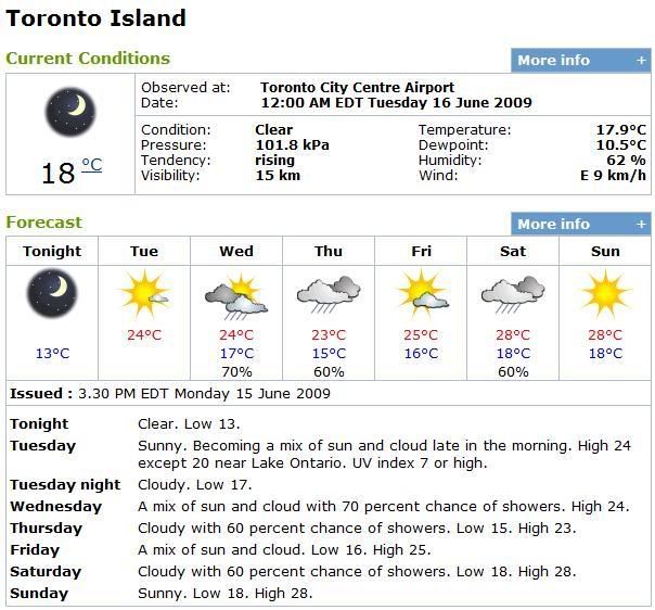
TI.jpg


Source: http://weatheroffice.gc.ca/city/pages/on-128_metric_e.html
 
Last edited:
Special weather statement issued for..
City of Toronto
Windsor - Essex - Chatham-Kent
Sarnia - Lambton
Elgin
London - Middlesex
Simcoe - Delhi - Norfolk
Dunnville - Caledonia - Haldimand
Oxford - Brant
Niagara
City of Hamilton
Halton - Peel
York - Durham
Huron - Perth
Waterloo - Wellington
Dufferin - Innisfil
Grey - Bruce
Barrie - Orillia - Midland.

Possibility for strong thunderstorms tonight into Saturday morning..

A warm front will move eastward into the Windsor area this evening
and thunderstorms will develop. Some of these thunderstorms could
become severe with the main concerns being heavy downpours - frequent
lightning - gusty winds and large hail. There is uncertainty where
the stronger storms will develop and they may remain over the Windsor
to London corridor. Many regions may not see showers or isolated
thunderstorms until overnight or early Saturday morning.

Severe thunderstorm watches or warnings may be issued. The Ontario
storm prediction centre will monitor the situation and update
statements as needed.
 

Back
Top