News   GLOBAL  |  Apr 02, 2020
 8.8K     0 
News   GLOBAL  |  Apr 01, 2020
 40K     0 
News   GLOBAL  |  Apr 01, 2020
 5.1K     0 

Re: yllianos

Really good looking map except I think you would definitely need the relief. My preference being across Front. And Georgetown GO should be extended to Kitchener.
 
I've always wondered if the southern portion of the Don Mills line (from Pape station to Pape and Queen would be above ground or below. It's a pretty densely built up neighbourhood, and it would seem prohibitively expensive to build under.

They could use Carlaw and Pape as southern routes but it doesn't seem to make sense either way. Any ideas?

I'm open to any ideas (within reason and cost) to what a proper solution would be in that area, most of the stops and route are based via Wikipedia (it's sad) and I chose the options that were in price reason.

Re: yllianos

Really good looking map except I think you would definitely need the relief. My preference being across Front. And Georgetown GO should be extended to Kitchener.

I'm going to add the DRL once an official "proposed route" is posted somewhere... From what I'm reading around, they want to re route it around Queen Street (I think) and so for now it'll be left out.

I'm all for GO being extended anywhere, I mean its not like their basis of operation is that extensive as the TTC. The stations are concrete slabs and the track is just laid down.
 
A really poorly drawn map (thanks, MS Paint!), but here's mine

threeloops2a.jpg


  • The YUS will end a couple of stops north of Steeles. Two stops between the northernmost stop on the Yonge side and the VCC.
  • The Sheppard and Bloor/Danforth lines are technically supposed to be one loop (despite the two different colours). Notice that the SRT is gone, absorbed by a BD-Sheppard extension.
  • DRL/Eglinton Loop - Downtown runs along Richmond. - I know, it doesn't look like it goes far east enough on the southern portion...
 
Last edited:
Cold, rainy day, so time for a new map. Possibly my best yet.

subwaymap.jpg


Some notes:
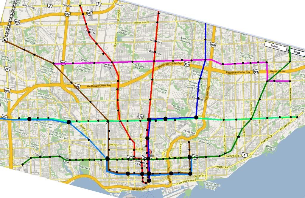
1) Each colour represents a separate, full service subway line. There are 7 lines and 130 stations.
2) Where two lines run parallel to each other, there is a 4 track alignment consisting of one local line, and one express line.
3) At single line segments, all trains stop at all black dots.
4) At dual line segments, local trains stop at both small and large dots. Express trains only stop at large dots.
5) The super node is relocated from Yonge and Bloor to Yonge and Dundas. Four lines service Yonge and Dundas.

Advantages:
1) Pearson Airport is 6 stops away from downtown, via the light blue line, and also accessible along Eglinton.
2) Yonge line gets express service south of Eglinton.
3) There is a DRL from the east and west offering both express and local service to downtown. The existing Dufferin and approximately Coxwell stations on BD are only 3 stops away from downtown via an express train.

Quick disclaimer:
1) My familiarity with the city drops off substantially outside of central Toronto and North York. If a subway line or a station should more logically be a few streets over, it's an innocent mistake. I probably even missed a few existing stops on Bloor or put them in the wrong place.
2) I chose Dundas as the downtown subway corridor, but it could just as easily be Queen St. I just think that Dundas Square is a better spot for the main transfer point than Queen for whatever reason.

I would expect that if this map is the basis of any subway construction that double tracking yonge would not make sense - in fact double routing any line makes no sense. I would take the existing University line and take it more northerly, while taking the spadina run and run it directly down spadina and in Union Station - giving three lines coming in north south in that area (but I would make other things more high priority. I would also not run too lines along dundas. If they are going to build too lines I would expect one along Adelaide St. and one on Dundas St.
 
Not really a "fantasy" map, it's based on what's planned and what's been proposed.

3290009632_bf274dbca4_b.jpg


The western extension of the Bloor line is all EA-approved already up to Dixie.

The western leg of the Eglinton line is what is planned as LRT up to Pearson.

The eastern leg continues to Kennedy station.

The Sheppard line is extended west to Downsview, and east to STC.

Spadina and Yonge extended as planned.

Danforth replaces the SRT to STC.

Only thing missing is the DRL.
 
It took me a while, but I updated my own fantasy map to incorporate suggestions here. These included:

- extension of the Downtown-Don Mills line to Seneca College
- extension of the Sheppard-Finch line to Woodbine and the Airport and the Eglinton-Crosstown line to meet it.
- revision of the Downtown-Don Mills line to favour a Wellington Street alignment
- Removal of all "North" and "South" stations and replacing them with neighbourhood names.
- Removal of "Jethro" (Wilson/Jane) which, while nice, is a little silly. "Beverly Hills" was used instead.

...James

That's an interesting map. What made you decide to make the York U station part of the Sheppard line? Also, I'm assuming that the Sheppard and Eglinton lines aren't meant to be a "U" shape like YUS, right? They're different colours after all.
 
I actually think that the York University extension, as it is now conceived, would be better suited as an extension of the Sheppard rather than the Spadina subway. You could build the line to Sheppard standards and save a little money, and I think there is a fair amount of crosstown potential -- people wanting to get to York University from the northeastern part of town. Once the current line reaches Vaughan Centre, it might make more sense to aim it west towards Brampton, and the Sheppard line would be better for that than the Y-U-S, which would be getting grotesquely long at this point.

Of course, in my fantasy map, this doesn't happen. Instead, after heading into the centre of the York U campus, it curves back to Finch Avenue and heads west.

And, no, the Finch and Eglinton subways aren't interlined at the Airport. There's just a large terminal there. Interlining would thwart further extensions to the west.

I should note, though, that in the story where this map becomes a reality, it's only due to the infusion of extremely cheap troll labour. :)

...James
 
Here's mine. It shows subways, the Metrolinx express rail lines, and LRT that's underground, elevated, or off-street. So most of the Transit City lines aren't shown. Some highlights:

  • Bloor-Danforth extensions to STC and Sherway
  • Sheppard extensions to STC and Downsview
  • DRL along Don Mills, Wellington, and Dufferin. I'd call it either the Grand Trunk line or the Union line. Union, St. Andrew, and King would turn into a single massive hub.
  • Eglinton LRT would follow the Richview right of way to Pearson
  • Queen streetcar tunnel through downtown, connecting with the express rail lines at 4 locations
  • A grade separated Port Lands LRT which would go as far east as the Beaches
  • Electrified express rail with headways as short as 5 minutes serving Hamilton, MCC, Pearson, Brampton, Richmond Hill, and Oshawa
transit.png


transit2.png
 
Last edited:
^^

This map may have some merit to the TTC as the Eglinton LRT abruptly ends before entering Scarborough :p


How's this for Scarborough... The main points being the extension of the DRL along the CPR corridor and up to Malvern, along with a complete Sheppard subway to STC.
untitled-1.jpg
 
Last edited:
For the past few days I have been working on a schematic version of my map and I also made a few changes as well. Check it out:

 
For the past few days I have been working on a schematic version of my map and I also made a few changes as well. Check it out:


Very cool! :)
 

Back
Top