News   GLOBAL  |  Apr 02, 2020
 8.9K     0 
News   GLOBAL  |  Apr 01, 2020
 40K     0 
News   GLOBAL  |  Apr 01, 2020
 5.1K     0 

Really? The Imperial Pub was a hotel? Makes sense. The Pantages-Canon Theatre (across the street) was also called the The Imperial/The Imperial Six. Could this be a historic block of old row buildings?

I'd forgotten that Toronto businesses back in the day would often take the name of a nearby "landmark". The New Orpheum Grill - now the Rosebud (669 Queen west) took on the name of the Orpheum theatre (600 Queen west). The Rosebud still uses the old over-sidewalk sign of its predecessor; it's been painted over in new colours. By the by, the New Orpheum Grill was the progenitor of the late and by some, somehow lamented Mr. Pong's Chinese Food. Does anyone remember their fleet of delivery cars? Their mascot was a panda bear...

Circle Shoes (2597 Yonge) - still doing business - took on its name from the nearby Circle theatre (2567 Yonge).

Circle_Theatre_isometric_drawing_19.jpg


The theatre became a Power supermarket - I don't know when - and was torn down in the late 60s.
 
Circle Shoes (2597 Yonge) - still doing business - took on its name from the nearby Circle theatre (2567 Yonge).

Circle_Theatre_isometric_drawing_19.jpg


The theatre became a Power supermarket - I don't know when - and was torn down in the late 60s.

what a great find!

a very beautiful piece of Deco ephemera--thanks for that...
 
Thanks for the theatre pictures! I have many happy memories of the Eglinton Theatre, and the Capitol Theatre, although the Circle Theatre, and the one on Avenue Road north of Lawrence were before my time.

I'm off to Yorkdale now, and found this photo in the Toronto Archives. I love how the blue in the car in the foreground matches the blue in the parking lot signage:

f0217_s0249_fl0199_it0001.jpg


I wonder if the parking lot has even been that empty since the 1960's....
 
Really? The Imperial Pub was a hotel? Makes sense. The Pantages-Canon Theatre (across the street) was also called the The Imperial/The Imperial Six. Could this be a historic block of old row buildings?

Could be, but it's unlikely; there's an Imperial Theatre in St John, NB as well.
 
April 10 addition.


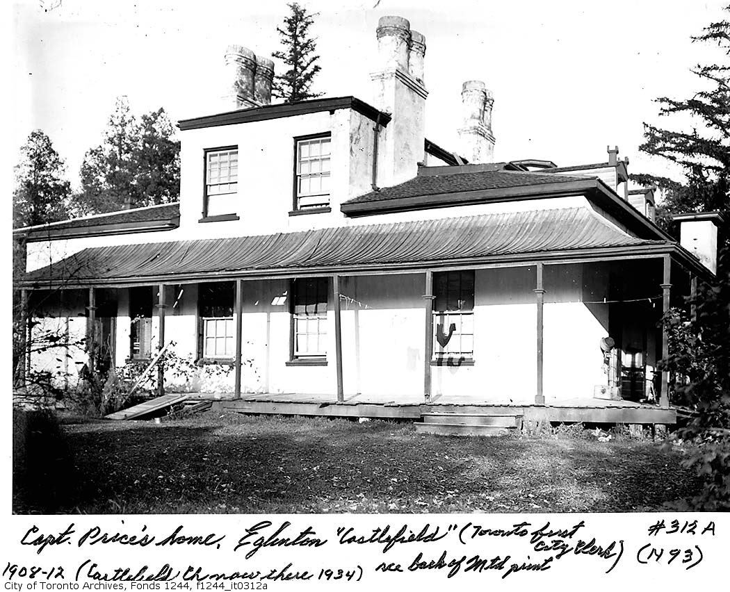
Then: "Castlefield" 1908.


f1244_it0312a.jpg


"Castlefield

James Hervey Price, a lawyer, came to Upper Canada in 1828. After establishing a law practice in York he was able to lot 2, in the first concession west of Yonge Street for f,1,000. This ran west from Yonge Street to Bathurst, between modern Roselawn Avenue and a line just north of Briar Hill Avenue. Two streams, Mud Creek and Yellow Creek, ran through the estate. Castlefield was a red-brick Neo-Gothic residence with four crenellated turrets. It stood east of modern Duplex Avenue. Two turrets flanked the massive double doorway. The long drive to Yonge Street (todays Castlefield Avenue) was lined with elms. There were cottages for the farmer and the coachman, several stables, a barn, with a three-acre orchard in front. In 1834, he was appointed the first City Clerk of the newly incorporated City of Toronto. He was a close associate and supporter of William Lyon Mackenzie, the city's first mayor. Price provided Mackenzie and the Reformers with funds and a place for meetings, but did not support armed rebellion in 1837.

In 1842, Price sold Castlefield to Franklin Jackes, a baker who made a fortune during a flour shortage in 1825. Flour had to come all the way from the mills at Kingston in the 1820s, and severe storms were wreaking havoc on shipping. Jackes was waiting on the wharf one day, when a desperate agent blurted that he would sell off his long overdue shipment for L5, believing it was at the bottom of Lake Ontario. Jackes took up his offer and, when the vessel later sailed into Toronto Harbour, he became a wealthy man. and moved to Eglinton. While he was clearing and ploughing fields, he turned up pottery, pipes, and spearheads from a Huron village that once occupied the site. He died of smallpox at Castlefield at forty-eight years of age and his oldest son, William, bought Castlefteld from his mother. William Jackcs sold the estate to developers in 1885. The Castlefield house remained there until it was demolished in 1918. Castlewood Road, Castle Knock Road, and Castlefield Avenue recall that earlier time."

http://www.lostrivers.ca/points/Castlefield.htm
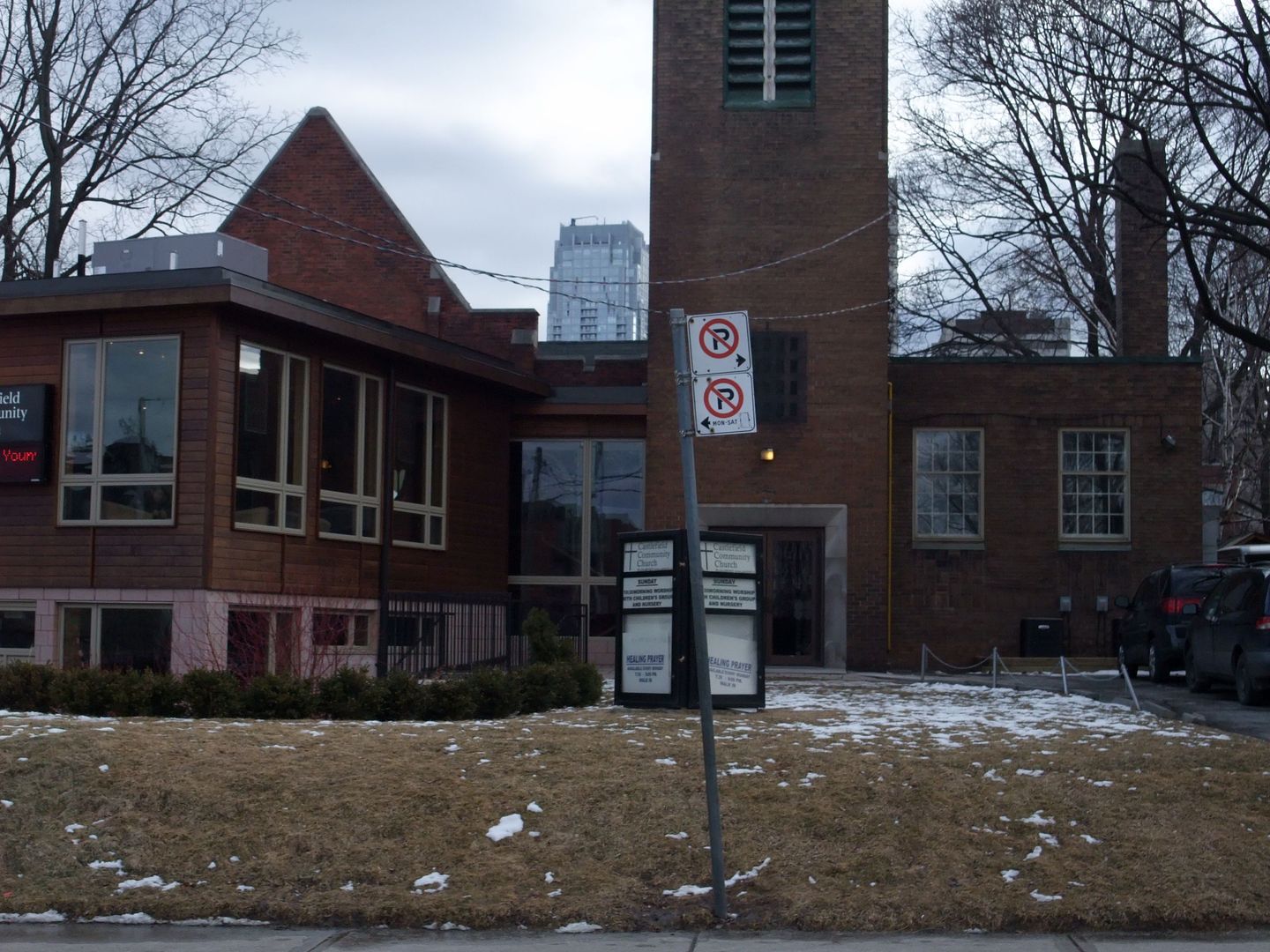

Now: December 2009.


DSCF1425.jpg
 
Very interesting, Mustapha. Here's a map of the area from the 1910 Goad. Do you think "Castelfield" is the building on the south side of Castelfield near Yonge near the number 5?

yongecastelfireld-1.jpg
 
If that's a photograph of Price's home in 1908, it doesn't look much like the red-brick Neo-Gothic residence with four crenellated turrets flanking a massive double doorway that's described, does it?
 
This doesn't look much like red-brick but it appears to have four crenellated turrets flanking a massive double doorway...

pictures-r-3903.jpg


Could the other photo be of the back of Castlefield? Is that a turret poking just above the roofline on the right?
 
I'm mystified as to why there is such a difference between the two photos. Could my photo have been mistakenly captioned?
I think the older photo is probably NOT "Castlefield" - could it be a 'gatehouse' or servant's quarters? Even after 25 years of ownership by a developer it does not look 'grand' enough! (Nor 'castle-enough'.)
 
I think I recall that church tower having a 1940 datestone or something--intriguing...

Or possibly 1939?
http://www.getstockphotos.ca/images/2084600645

I'm mystified as to why there is such a difference between the two photos. Could my photo have been mistakenly captioned?

There have been other errors in some of those captions.

Here is another picture of Mustapha's house, with the caption " House on corner of Castlefield Avenue and Yonge Street, 1900"
http://www.getstockphotos.ca/images/2085100035

Liz Lundell's "Estates of Old Toronto" says “the long drive (today’s Castlefield Avenue) was lined with elms, and the house stood slightly east of modern Duplex Avenue… the house was demolished in 1918 to make way for Duplex Avenue”

Very interesting, Mustapha. Here's a map of the area from the 1910 Goad. Do you think "Castelfield" is the building on the south side of Castelfield near Yonge near the number 5?
Duplex Ave probably incorporated Boydell Pl on that map – number 5 looks like it would be right in the path.

p.s. Estates of Old Toronto also says ``there were separate cottages for the tenant farmer and coachman, several stables, a barn, and a three-acre orchard in front of the house``
 
Last edited:

Back
Top