Hopkins123
Senior Member
I've put this in the appropriate thread, over from the Relief Line thread.
Because I am to please:

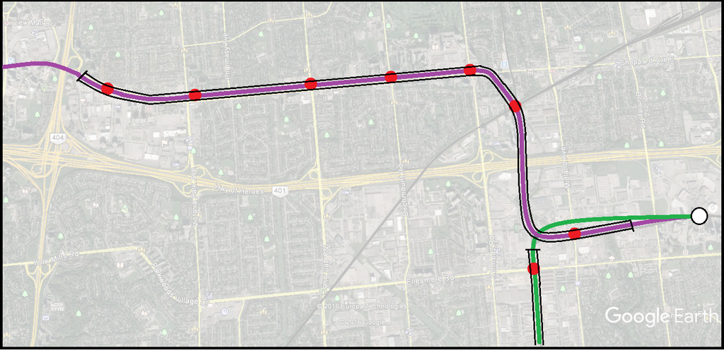
As you can see, the subway emerges out of a portal on the southeast side of Highway 404 and immediately has a station at Consumers Rd. About 500 metres east of the station the line bridges over Sheppard Ave to transition towards the next station just east of Victoria Park Ave. The alignment stays on the north side of Sheppard on land currently that's a green space strip, with further stations at Warden and Birchmount. The Kennedy station would provide access to Agincourt Mall. About 200 metres east of the station the line veers southeast into the Highland Creek alignment to have the GO interchange station at the rail junction. The next section descends to at-grade level to travel underneath the 401 in an expanded rail underpass, then elevates again to align with a newly constructed and fortified Midland station. The new subway-ready elevated guideway continues for another kilometre til near Brimley where it descends underground. Scarborough Centre Stn exists in its same location with a St George style interchange between the BD and Sheppard Lines (BD follows the existing SRT corridor at grade, with a revamped Kennedy Station and a tunneled section with a wider curve north of Ellesmere station). This allows for either subway line to extend further towards Malvern in the future if funding permits.
I do like this this alot, but I think it should above ground entirely from O' Connor to Sheppard ave, we need to save as much money as possible. Is there a way you could get a map like this done for an elevated Sheppard subway and Scarborough subway?
Because I am to please:

As you can see, the subway emerges out of a portal on the southeast side of Highway 404 and immediately has a station at Consumers Rd. About 500 metres east of the station the line bridges over Sheppard Ave to transition towards the next station just east of Victoria Park Ave. The alignment stays on the north side of Sheppard on land currently that's a green space strip, with further stations at Warden and Birchmount. The Kennedy station would provide access to Agincourt Mall. About 200 metres east of the station the line veers southeast into the Highland Creek alignment to have the GO interchange station at the rail junction. The next section descends to at-grade level to travel underneath the 401 in an expanded rail underpass, then elevates again to align with a newly constructed and fortified Midland station. The new subway-ready elevated guideway continues for another kilometre til near Brimley where it descends underground. Scarborough Centre Stn exists in its same location with a St George style interchange between the BD and Sheppard Lines (BD follows the existing SRT corridor at grade, with a revamped Kennedy Station and a tunneled section with a wider curve north of Ellesmere station). This allows for either subway line to extend further towards Malvern in the future if funding permits.


